
Midlothian is a historic county, registration county, lieutenancy area and one of 32 council areas of Scotland used for local government. Midlothian lies in the east-central Lowlands, bordering the City of Edinburgh council area, East Lothian and the Scottish Borders.

Queensferry, also called South Queensferry or simply "The Ferry", is a town to the west of Edinburgh, Scotland. Traditionally a royal burgh of West Lothian, it is now administered by the City of Edinburgh Council. It lies ten miles to the north-west of Edinburgh city centre, on the shore of the Firth of Forth between the Forth Bridge, Forth Road Bridge and the Queensferry Crossing. The prefix South serves to distinguish it from North Queensferry, on the opposite shore of the Forth. Both towns derive their name from the ferry service established by Queen Margaret in the 11th century, which continued to operate at the town until 1964, when the Road Bridge was opened.

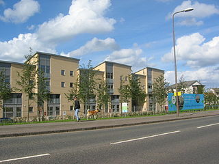
Uphall is a village in West Lothian, Scotland. It is a swiftly growing village in a conurbation with Broxburn to the east, Dechmont to the west and the major town of Livingston to the south west. Uphall is 30 miles from Glasgow and 14 miles from Edinburgh in the Scottish Lowlands. Uphall Station and Pumpherston are separate villages that lie to the south of Uphall.

Carnoustie is a town and former police burgh in the council area of Angus, Scotland. It is at the mouth of the Barry Burn on the North Sea coast. In the 2011 census, Carnoustie had a population of 11,394, making it the fourth-largest town in Angus. The town was founded in the late 18th century, and grew rapidly throughout the 19th century due to the growth of the local textile industry. It was popular as a tourist resort from the early Victorian era up to the latter half of the 20th century, due to its seaside location, and is best known for the Carnoustie Golf Links course that often hosts the Open Championship.

Newington is a neighbourhood of southern Edinburgh, Scotland. Developed from the early 19th century, it is an affluent, predominantly residential area.
Corstorphine is an area of the Scottish capital city of Edinburgh. Formerly a separate village and parish to the west of Edinburgh, it is now a suburb of the city, having been formally incorporated into it in 1920.
Silverknowes is a district of Edinburgh, Scotland. Silverknowes lies to the northwest of the city. The district contains over 2000 homes, ranging in size from bungalow to semi-detached housing, much of it built during the mid-twentieth century.

Barnton is a suburb of Edinburgh, Scotland, in the north-west of the city, between Cramond and Corstorphine Hill and west of Davidsons Mains. Part of the area was traditionally known as "Cramond Muir" in reference to Cramond to the north.
Niddrie is a residential suburb in Edinburgh, Scotland. It is situated in the south-east of the city, south-west of the seaside area of Portobello, and west of Musselburgh in East Lothian near Fort Kinnaird retail park. The western section of Niddrie is also known by the alternative name of Craigmillar.
Tollcross is a major road junction to the south west of the city centre of Edinburgh, Scotland which takes its name from a local historical land area.

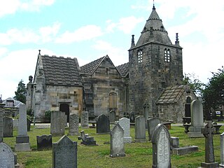
Lasswade is a village and civil parish in Midlothian, Scotland, on the River North Esk, nine miles south of Edinburgh city centre, contiguous with Bonnyrigg and between Dalkeith to the east and Loanhead to the west. Melville Castle lies to the north east. The Gaelic form is Leas Bhaid, meaning the "clump at the fort."

Gifford is a village in the parish of Yester in East Lothian, Scotland. It lies approximately 4 miles (6.4 km) south of Haddington and 25 miles (40 km) east of Edinburgh.

Liberton is a suburb of Edinburgh, the capital of Scotland. It is in the south of the city, south of The Inch, east of the Braid Hills and west of Moredun.

Prestonfield House is a boutique hotel in Prestonfield, Edinburgh, Scotland. Originally built in 1687 by architect Sir William Bruce, it was once considered a wealthy rural estate, however in recent decades, it has come to serve as a hotel. Although it falls on the small side as an establishment, having only 23 rooms, it is well-known to hotel and hospitality critics. The hotel is at the foot of Arthur's Seat and has a large roundhouse, previously used for keeping horses. The stables were repurposed and now host events, including the "Taste of Scotland Festival".

The following outline is provided as an overview of and topical guide to Edinburgh:
Sir James Dick of Prestonfield was a 17th and 18th century Scottish merchant who served as Lord Provost of Edinburgh from 1679 to 1681. He was the first Baronet of Prestonfield and was progenitor to the Dick baronets.

Eastwood is a residential neighbourhood in the city of Glasgow, Scotland. It is situated south of the River Clyde, and is part of the Newlands/Auldburn ward under Glasgow City Council.
Thomas Hamilton, Lord Priestfield (c.1535–1611) was a 16th/17th century Scottish judge and Senator of the College of Justice.

Priestfield Parish Church, Edinburgh is a member of the Church of Scotland, in the presbytery of Edinburgh. It is located approximately 1.5 miles (2.4 km) south of Edinburgh city centre on Dalkeith Road at its junction with Marchhall Place. The church building was completed in 1880 and is now a category A listed building.
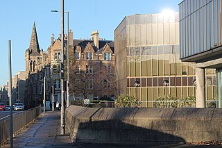
St Leonard's is a neighbourhood of south-central Edinburgh, Scotland, United Kingdom. Once notable as a centre of industry, it is now primarily residential.


