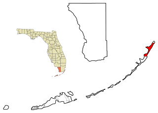
North Key Largo is an unincorporated area and census-designated place (CDP) in Monroe County, Florida, United States. The population was 1,431 at the 2020 census, up from 1,244 in 2010. It includes two private clubs, the Ocean Reef Club and the Key Largo Anglers Club, and is reached from the mainland via the Card Sound Bridge.

Craigcrook is a suburb of Edinburgh, Scotland, best known for Craigcrook Castle. It is fairly affluent, and lies on the north east slopes of Corstorphine Hill. It is near Clerwood, and Blackhall. Davidson's Mains lies to the north, separated from the district by the A90 - Queensferry Road.
Pilton is a residential area of northern Edinburgh, Scotland. It is to the north of Ferry Road, immediately east of Muirhouse, and to the west and south of Granton.
Drumbrae or Drum Brae is the name of a suburb of west Edinburgh, Scotland generally considered to be part of the neighbouring larger areas of Corstorphine and Clermiston. This is a commuter settlement as many people who live in the area travel to the centre of town to attend work.

Polwarth is a mainly residential area of Edinburgh, Scotland. It is bounded by Bruntsfield and Merchiston to the east and south, Gorgie and Dalry to the north, Fountainbridge to the north and east, and Craiglockhart to the west.

Bingham is a suburb of Edinburgh, the capital of Scotland. It is east of Duddingston, west of Magdalene, south of Portobello and north of Niddrie. The main A1 road skirts Bingham to the north.
Chesser is a mainly residential suburb of Edinburgh, Scotland, east of the Water of Leith. It, with Longstone, is to the south-west, Allan Park and Craiglockhart to the south, Slateford, Hutchison and Moat to the east, and Gorgie Road to the north.
Little France is a suburb of Edinburgh, the capital of Scotland. It is on the A7, approximately 4 miles (6.4 km) south of the city centre.
Moredun is a district in the south-east of Edinburgh, the capital of Scotland. It is east of Liberton, while Craigour is situated just to its north.

Redford is a suburb of Edinburgh, the capital of Scotland. It is in the south-west of the city, south-east of the Colinton area, and is known particularly for Redford Barracks, an army base.

Warriston is a suburb of Edinburgh, the capital of Scotland. It lies east of the Royal Botanic Garden in Inverleith. The name derives from Warriston House, a local mansion house demolished in 1966.
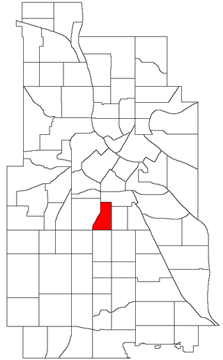
Phillips West is a neighborhood within the Phillips community in Minneapolis. Its boundaries are East 22nd Street to the north, Chicago Avenue to the east, East Lake Street to the south, and Interstate 35W to the west. It is entirely located within Minneapolis City Council Ward 6, represented by Jamal Osman.

The A701 is a major road in Scotland that runs from Dumfries to Edinburgh.

Dalkeith Thistle Football Club are a Scottish football club from the town of Dalkeith, Midlothian. Formed in 1892, the team plays in the East of Scotland Football League, having moved from the junior leagues in 2018.

Edinburgh United Football Club is a Scottish football club, based in the Colinton area of Edinburgh. Formed in 1985, the team competes in the East of Scotland Football League First Division Conference B, having moved from the junior leagues in 2018.
Jordan is an unincorporated community in Johnston County, North Carolina, United States, off North Carolina Highway 42, and North Carolina Highway 96, east of Flowers. It lies at an elevation of 266 feet.
Westview Terrace is a Roanoke, Virginia neighborhood located in northwest Roanoke. It borders the neighborhoods of Peachtree/Norwood on the west, Villa Heights and Washington Heights on the south and Miller Court/Arrowood on the north and east. The neighborhood is predominantly residential in character throughout its area with limited commercial development along its Virginia State Route 117 frontage. Its development patterns typical of those experienced for an American city during the mid-20th century with low-density housing.

The A772 was a major A road located in Edinburgh, Scotland. The A772 was originally the A7 before a major renumbering of the roads into Edinburgh and also begins there, at a junction with the A701 in the neighbourhood of Nether Liberton. From this junction, the A772 heads south-east through Gilmerton, a suburb of Edinburgh. This part is known as Gilmerton Road and has a 30 mph speed limit. At the edge of Gilmerton, the road becomes Drum Street, where it passes The Drum, an 18th-century country house, before reverting to Gilmerton Road.
Sovetscoe or Sovietscoe is a commune in the Rîbnița District of Transnistria, Moldova. It is composed of two villages, Sovetscoe and Vasilievca (Васильевка). It has since 1990 been administered as a part of the self-proclaimed Pridnestrovian Moldavian Republic.
Occupy Edinburgh was a protest against economic and social inequality as part of the global Occupy movement.
