
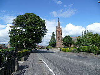
Hairmyres is an area of East Kilbride in South Lanarkshire, Scotland, situated on the west side of the town, close to the main road to Eaglesham and Kilmarnock. It is 2+1⁄4 miles from the Glasgow City Council boundary at the Carmunnock Bypass and nine miles south of the city centre of Glasgow.
Craiglockhart is a suburb in the south west of Edinburgh, Scotland, lying between Colinton to the south, Morningside to the east Merchiston to the north east, and Longstone and Kingsknowe to the west. The Water of Leith is also to the west.

The Water of Leith Walkway is a public footpath and cycleway that runs alongside the river of the same name through Edinburgh, Scotland, from Balerno to Leith.
Merchiston is a residential area around Merchiston Avenue in the south-west of Edinburgh, Scotland.

Ardmillan is a mainly residential suburb of Edinburgh, Scotland. The area developed during the mid to late Victorian era as Edinburgh expanded and many of the present tenement flats and houses date from this era. The area is bisected by the A70 road and its north-west edge is marked by the Shotts railway line. The area has several pubs, small shops, churches and a cemetery.
Sighthill is a suburb in the west of Edinburgh, Scotland. The area is bordered by Broomhouse and Parkhead to the east, South Gyle to the north, the industrial suburb of Bankhead and the Calders neighbourhood to the west, and Wester Hailes to the south. It is sometimes included in the Wester Hailes area, while the Calders, Bankhead and Parkhead are sometimes considered parts of Sighthill. Administratively it has formed a core part of the City of Edinburgh Council's Sighthill/Gorgie ward since 2007.

Meadowbank is a suburb of Edinburgh in Scotland. It is best known for Meadowbank Stadium, a multi-purpose sports facility that opened as an international sports stadium in 1970. The stadium closed in 2017 and was redeveloped as a local sports and athletics facility that was officially opened on 4 November 2022.
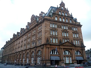
Princes Street Station was a mainline railway station which stood at the west end of Princes Street, in Edinburgh, Scotland, for almost 100 years. Temporary stations were opened in 1848 and 1870, with construction of the main station commencing in the 1890s. The station was closed completely in 1965 and largely demolished in 1969–70. Only its hotel remains, but it is no longer in railway ownership.

Ashton Park Parade railway station was a station on the line between Guide Bridge and Stalybridge in Greater Manchester, England. This station served the town of Ashton-under-Lyne, now served only by Ashton Charlestown, north of this former station.
Chesser is a mainly residential suburb of Edinburgh, Scotland, east of the Water of Leith. It, with Longstone, is to the south-west, Allan Park and Craiglockhart to the south, Slateford, Hutchison and Moat to the east, and Gorgie Road to the north.

Church Hill is a street and small surrounding area in Edinburgh, Scotland.

Carnwath railway station was located just west of the village of Carnwath, on the Caledonian Railway line between Carstairs railway station and Edinburgh.

Marchmont House lies on the east side of the village of Greenlaw, and near to a church in Polwarth in Berwickshire, in the Scottish Borders area of Scotland. It is about five miles south west of Duns, about 19 miles (31 km) west of Berwick-upon-Tweed and about 40 miles (64 km) south east of Edinburgh. Situated in a gently undulating landscape, the estate is intersected by Blackadder Water, and its tributary burns. With the Lammermuir Hills to the north and views towards the Cheviot Hills in the south, this part of Berwickshire, sometimes referred to as the Merse, is scenic and contains rich agricultural land.
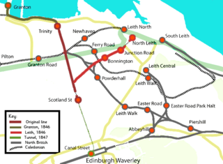
The Edinburgh, Leith and Newhaven Railway was a railway company formed in 1836 to connect the city of Edinburgh with the harbours on the Firth of Forth. When the line connected to Granton, the company name was changed to the Edinburgh, Leith and Granton Railway. It opened part of its route in 1846, but reaching the centre of Edinburgh involved the difficult construction of a long tunnel; this was opened in 1847. It was on a steep incline and was worked by rope haulage.

Merchiston railway station was a railway station which served the area of Merchiston in Edinburgh, Scotland, for around eighty years. The station was built by the Caledonian Railway between 1879 and 1883, with the last passenger service in September 1965. The station was demolished shortly afterwards and the track bed has become a footpath.

Scotland Street Station was a railway station which stood in a cutting at the north end of Scotland Street, in Edinburgh, Scotland. First opened as Canonmills by the Edinburgh, Leith and Newhaven Railway, Scotland Street stood at the southern end of Scotland Street Tunnel that linked the city centre under the New Town to Canal Street. The trains that used the station were rope hauled by stationary steam engine.
Shandon is an area of Edinburgh within North Merchiston approximately three miles west of the centre of Edinburgh. It is bounded by Slateford Road to the north, Harrison Road to the east, the Union Canal to the south and the Glasgow-Edinburgh Shotts Line and Suburban rail lines to the west.
Merchiston Park was a football ground in Bainsford, near Falkirk, which was the home of East Stirlingshire F.C. between c. 1882 and 1920. It was near Main Street, just north of the Forth and Clyde Canal at Bainsford Bridge.

Powderhall railway station served the area of Powderhall, Edinburgh, Scotland from 1895 to 1917 on the Edinburgh, Leith and Granton Line of the North British Railway.
South Queensferry railway station served the town of South Queensferry, Edinburgh, Scotland from 1868 to 1929 on the South Queensferry Branch.


