Canonmills

Last updated

Canonmills Clock Canonmills, Edinburgh.jpg
Canonmills Clock
Baxters Land lintel dated 1686 Baxters Land lintel, Canonmills Edinburgh.JPG
Baxters Land lintel dated 1686

Canonmills is a district of Edinburgh, [1] the capital of Scotland. It lies to the south east of the Royal Botanic Garden at Inverleith, east of Stockbridge and west of Bellevue, in a low hollow north of Edinburgh's New Town. The area was formerly a loch which was drained in three phases in the 18th and 19th centuries, disappearing finally in 1865.

Contents

History

Holyrood Abbey

Formerly a small village, Canonmills owes its origins and name, in the same way as The Canongate, to the Augustinian canons of Holyrood Abbey who operated a mill here from the 12th century. [2] It is shown pictorially as a cluster of buildings, three of which have waterwheels, on the 1560 Siege of Leith map. At a later period a mill lade from the Water of Leith reached the area via the village of Silvermills to the east. The Incorporation of Baxters (bakers) in the Canongate were compelled by law to have their corn ground at the Canonmills, and during demolition work carried out in 1964 to enlarge a local filling station a stone was unearthed bearing the inscription, "The Baxters Land 1686". It is now incorporated into a wall of the Canonmills Service Station. The only surviving building of the original village is a pantile-roofed former mill building on the corner of Eyre Place and Canon Street. Until c.1995 further remnants existed on Eyre Terrace.

Canonmills Loch

Canonmills Loch shown on a map from 1804 Canonmills Loch, Ainslie 1804.JPG
Canonmills Loch shown on a map from 1804

In winter this small man-made loch was used for curling. Canonmills Curling Society were painted by David Allan c.1796 (which is also one of the earliest paintings of this area). [3] The loch survived until the late 19th century, at which point it was infilled and built over. [4]

George V Park

The George V Park, occupying the old Canon Mill Haugh to the south east, used to be a popular sporting arena. With the final draining of the loch in 1865 it became the site of the Royal Patent Gymnasium, described by James Grant as "...one of the most remarkable and attractive places of its kind in Edinburgh", created "at considerable expense for the purpose of affording healthful and exhilarating recreation in the open air". The principal feature was the circular Great Sea Serpent which could seat 600 rowers embarking and disembarking at four separate piers. Other attractions were the Self-Adjusting Trapeze enabling up to 100 patrons at a time to swing by the hands "over a distance of 130 feet from one trapeze to the other", the Giant's Sea-Saw, 100 feet long by 7 wide, which could elevate 200 people to a height of 50 feet, and the Patent Velocipede Paddle Merry-go-Round propelled by the feet of 600 passengers. [5]

Scotland Street Tunnel

Northern end of the Scotland Street Tunnel Northern end of the Scotland Street Tunnel, Canonmills Edinburgh.jpg
Northern end of the Scotland Street Tunnel

At the southern edge of the Park, in the cliff-like drop from the streets of the New Town, lies the northern end of the Scotland Street Tunnel which once provided an underground rail link to Canal Street Station on the site of present-day Waverley Station. The tunnel, built under Scotland Street in 1847 by the Edinburgh, Leith and Newhaven Railway, is three quarters of a mile long and descends a 1 in 27 gradient. Trains descended the tunnel under gravity, controlled by two men operating handbrakes in two front wagons. Robert Louis Stevenson described the appearance in his 'Edinburgh: Picturesque Notes' (1879): "The Scotland Street Station, the sight of the train shooting out of its dark maw with the two guards upon the brake, the thought of its length and the many ponderous edifices and thoroughfares above, were certainly things of paramount impressiveness to a young mind." For the return journey, 150mm steel cables were attached to the trains which were pulled up the slope by a stationary winding-engine at the Waverley end.

Buildings

Canon Mill, the only surviving mill building The Canon Mill, Edinburgh.JPG
Canon Mill, the only surviving mill building

The bridge (generally called Canonmills Bridge) linking Canonmills to Inverleith Row was built in 1767, its single arch replaced by three arches in 1840. It was widened in 1896. [6]

The deep elliptical crescent of Eyre Crescent was built around Canonmills (or Eyre) House which was replaced in 1880-1 by a United Presbyterian Church [7] [8] which in turn has been replaced by a modern medical centre. A little lodge-type building on Rodney Street is the old school, where Sir Walter Scott's father was educated.[ citation needed ]

Famous Residents

The sculptor Stewart McGlashan had his granite yard at Canonmills Bridge and lived opposite, at 5 Brandon Street. [9]

Related Research Articles

Dean Village is a former village immediately northwest of the city centre of Edinburgh, Scotland. It is bounded by Belford Road to the south and west, Belgrave Crescent Gardens to the north and below the Dean Bridge to the east. It was formerly known as the "Water of Leith Village" and was a successful grain milling area for more than 800 years. At one time there were no fewer than eleven working mills there, driven by water from the Water of Leith.

<span class="mw-page-title-main">Royal Botanic Garden Edinburgh</span> Botanical garden in Edinburgh, Scotland

The Royal Botanic Garden Edinburgh (RBGE) is a scientific centre for the study of plants, their diversity and conservation, as well as a popular tourist attraction. Founded in 1670 as a physic garden to grow medicinal plants, today it occupies four sites across Scotland—Edinburgh, Dawyck, Logan and Benmore—each with its own specialist collection. The RBGE's living collection consists of more than 13,302 plant species, whilst the herbarium contains in excess of 3 million preserved specimens.

<span class="mw-page-title-main">Calton Hill</span> Hill in central Edinburgh, Scotland

Calton Hill is a hill in central Edinburgh, Scotland, situated beyond the east end of Princes Street and included in the city's UNESCO World Heritage Site. Views of, and from, the hill are often used in photographs and paintings of the city.

<span class="mw-page-title-main">Timeline of Edinburgh history</span> Timeline of history in Edinburgh, Scotland

This article is a timeline of the history of Edinburgh, Scotland, up to the present day. It traces its rise from an early hill fort and later royal residence to the bustling city and capital of Scotland that it is today.

<span class="mw-page-title-main">New Town, Edinburgh</span> Central area of Edinburgh, Scotland

The New Town is a central area of Edinburgh, the capital of Scotland. It was built in stages between 1767 and around 1850, and retains much of its original neo-classical and Georgian period architecture. Its best known street is Princes Street, facing Edinburgh Castle and the Old Town across the geological depression of the former Nor Loch. Together with the West End, the New Town was designated a UNESCO World Heritage Site alongside the Old Town in 1995. The area is also famed for the New Town Gardens, a heritage designation since March 2001.

<span class="mw-page-title-main">Stockbridge, Edinburgh</span> District in Scotland

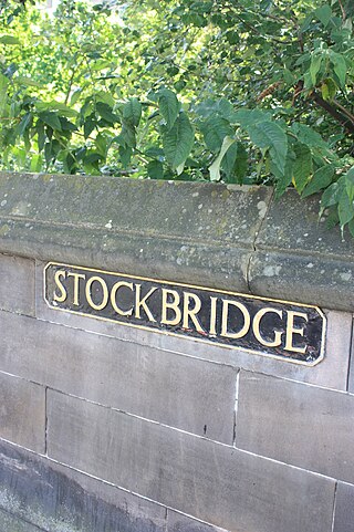
Stockbridge is a district of Edinburgh, located north of the city centre, bounded by the New Town and by Comely Bank. The name is Scots stock brig from Anglic stocc brycg, meaning a timber bridge. Originally a small outlying village, it was incorporated into the City of Edinburgh in the 19th century. The current "Stock Bridge", built in 1801, is a stone structure spanning the Water of Leith. The painter Henry Raeburn (1756–1823) owned two adjoining estates, Deanhaugh and St Bernard's, which he developed with the assistance of the architect James Milne. Milne was also responsible for the fine St Bernard's Church (1823) in Saxe Coburg Street. Ann Street, designed by Raeburn and named after his wife, is a rare early example of a New Town street with private front gardens.

<span class="mw-page-title-main">Inverleith</span> Human settlement in Scotland

Inverleith is an inner suburb in the north of Edinburgh, Scotland, on the fringes of the central region of the city. Its neighbours include Trinity to the north and the New Town to the south, with Canonmills at the south-east and Stockbridge at the south-west.

<span class="mw-page-title-main">Granton, Edinburgh</span> Edinburgh suburb

Granton is a district in the north of Edinburgh, Scotland. Granton forms part of Edinburgh's waterfront along the Firth of Forth and is, historically, an industrial area having a large harbour. Granton is part of Edinburgh's large scale waterfront regeneration programme.

<span class="mw-page-title-main">Powderhall</span>

Powderhall is an area lying between Broughton Road and Warriston Road in the north of Edinburgh, the Scottish capital. Until recently it was best known for Powderhall Stadium, a greyhound racing track, which has now closed. The stadium also played host to motorcycle speedway racing from 1977 to 1995, as home to the Edinburgh Monarchs, who have since relocated to Armadale. The Powderhall Sprint, first held in 1870, was a professional footrace with handicapping of the runners. It continues, since 1999, as the New Year Sprint and is now held at Musselburgh Racecourse.

<span class="mw-page-title-main">The Canongate</span> A district of Edinburgh, the capital city of Scotland.

The Canongate is a street and associated district in central Edinburgh, the capital city of Scotland. The street forms the main eastern length of the Royal Mile while the district is the main eastern section of Edinburgh's Old Town.

<span class="mw-page-title-main">Old Town, Edinburgh</span> The oldest part of Edinburgh

The Old Town is the name popularly given to the oldest part of Scotland's capital city of Edinburgh. The area has preserved much of its medieval street plan and many Reformation-era buildings. Together with the 18th/19th-century New Town, and West End, it forms part of a protected UNESCO World Heritage Site.

<span class="mw-page-title-main">Comely Bank</span>

Comely Bank is an area of Edinburgh, the capital of Scotland. It lies southwest of Royal Botanic Garden and is situated between Stockbridge and Craigleith. It is bound on its northernmost point by Carrington Road and on its southernmost point by Learmonth Terrace. The area is covered by Stockbridge and Inverleith Community Council.

Silvermills, once an ancient village, has been part of Edinburgh since 1809.

<span class="mw-page-title-main">Leith Walk</span> Street in Edinburgh, Scotland

Leith Walk is one of the longest streets in Edinburgh, Scotland, and is the main road connecting the east end of the city centre to Leith.

<span class="mw-page-title-main">Edinburgh, Leith and Newhaven Railway</span> Former railway line in Scotland

The Edinburgh, Leith and Newhaven Railway was a railway company formed in 1836 to connect the city of Edinburgh with the harbours on the Firth of Forth. When the line connected to Granton, the company name was changed to the Edinburgh, Leith and Granton Railway. It opened part of its route in 1846, but reaching the centre of Edinburgh involved the difficult construction of a long tunnel; this was opened in 1847. It was on a steep incline and was worked by rope haulage.

<span class="mw-page-title-main">St Andrew Square, Edinburgh</span> Garden square in Edinburgh, Scotland

St Andrew Square is a garden square in Edinburgh, Scotland located at the east end of George Street.

<span class="mw-page-title-main">Outline of Edinburgh</span> Overview of and topical guide to Edinburgh

The following outline is provided as an overview of and topical guide to Edinburgh:

<span class="mw-page-title-main">Inverleith (ward)</span> Edinburgh ward

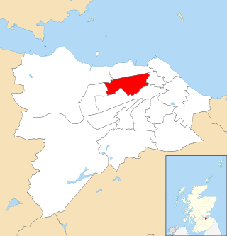
Inverleith is one of the seventeen wards used to elect members of the City of Edinburgh Council. Established in 2007 along with the other wards, it currently elects four Councillors.

Bellevue is a district of Edinburgh, the capital of Scotland. It lies to the south east of Canonmills, west of Leith Walk and south of Leith, incorporating the easternmost extent of Edinburgh's New Town UNESCO heritage site. The area was formerly open fields which became the second and penultimate location of the Royal Botanic Garden in 1763 .

References

  1. M., Munro, David (2006). Scotland : an encyclopedia of places & landscapes. Gittings, B. M. (Bruce M.), Royal Scottish Geographical Society. Glasgow: Collins. p. 105. ISBN   9780004724669. OCLC   225152110.{{cite book}}: CS1 maint: multiple names: authors list (link)
  2. Grant, James. Old and New Edinburgh. Vol. 5. Retrieved 4 June 2011.
  3. Curling: An Illustrated History, by David B Smith ISBN 0 859976 074 X
  4. Ordnance survey maps: 1854 to 1895
  5. J M Wallace, Canonmills and Inverleith, pp.16-17
  6. Z Ashford, The Lands Of Warriston in The Book Of The Old Edinburgh Club, New Series vol.3, Edinburgh 1994, p.10
  7. Grant, James. Old and New Edinburgh. Vol. 5. Retrieved 4 June 2011.
  8. "Edinburgh - Canonmills" . Retrieved 4 June 2011.
  9. Edinburgh and Leith Post Office Directory 1900-1901

55°57′45.09″N3°11′59.33″W / 55.9625250°N 3.1998139°W / 55.9625250; -3.1998139