Craiglockhart is a suburb in the south west of Edinburgh, Scotland, lying between Colinton to the south, Morningside to the east Merchiston to the north east, and Longstone and Kingsknowe to the west. The Water of Leith is also to the west.
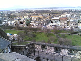
The New Town is a central area of Edinburgh, the capital of Scotland. It was built in stages between 1767 and around 1850, and retains much of its original neo-classical and Georgian period architecture. Its best known street is Princes Street, facing Edinburgh Castle and the Old Town across the geological depression of the former Nor Loch. Together with the West End, the New Town was designated a UNESCO World Heritage Site alongside the Old Town in 1995. The area is also famed for the New Town Gardens, a heritage designation since March 2001.

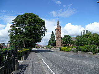
Shotts is a small town in North Lanarkshire, Scotland. It is located almost halfway between Glasgow and Edinburgh. The town has a population of about 8,840. A local story has Shotts being named after the legendary giant highwayman Bertram de Shotts, though toponymists give the Anglo-Saxon scēots as the real source of the name. Shotts is the home of the world famous Shotts and Dykehead Caledonia Pipe Band, 16 time winners of World Pipe Band Championships.

Abbeyhill is an area of Edinburgh, the capital of Scotland.

The Canongate is a street and associated district in central Edinburgh, the capital city of Scotland. The street forms the main eastern length of the Royal Mile while the district is the main eastern section of Edinburgh's Old Town.
Braidfauld is a small area of Glasgow, Scotland which is in the East End of the city slightly north of the River Clyde and south of the Tollcross area. It was also the name of the 45th ward of Glasgow City Council, prior to the re-organisation into multi-member wards in 2007.

Bonnington is a district of Edinburgh, the capital of Scotland. The area centres upon an original village which grew up around a ford on the Water of Leith, on the old boundary between Edinburgh and the port of Leith. Before the creation of Leith Walk, the road via the villages of Broughton and Bonnington, or Wester Road as it appears on some old maps, was one of two roads formerly connecting Edinburgh to Leith; the other being Easter Road. The district lies between the districts of Pilrig and Newhaven.
Lochend is a mainly residential suburb of Edinburgh, the capital of Scotland. It is named after Lochend Castle and the adjacent Lochend Loch, located in the western part of Restalrig on the boundary between Leith and The Canongate, approximately two miles from Edinburgh city centre. The suburb consists largely of a 1930s public housing estate, and is bounded on the west by Easter Road.

Pilrig is an area of Edinburgh, the capital of Scotland. The name probably derives from the long field (rig) on which a peel tower (pil/peel) stood. There is evidence of a peel tower situated on an area of higher ground above the Water of Leith.
Slateford is an area of Edinburgh, the capital of Scotland. It is east of the Water of Leith.

Great Junction Street is a street in Leith, on the northern outskirts of Edinburgh, Scotland. It runs southeast to northwest following approximately the southwestmost line of the old town walls around Leith.

Leith Central Railway Station was a railway station in Leith, Scotland. It formed the terminus of a North British Railway branch line from Edinburgh Waverley. The station was built on a large scale, and it included a trainshed over the platforms.

Leith Walk is one of the longest streets in Edinburgh, Scotland, and is the main road connecting the east end of the city centre to Leith.
Hibernian Park was the home ground of the Scottish football club Hibernian from 1880 until the club's dissolution in 1891. When the club was reformed in 1892, the club took out on a lease on a site which became known as Easter Road. Hibernian Park was also located in the Easter Road area; in fact, it was closer to Easter Road itself than the present stadium because it was on the site of what is now Bothwell Street.
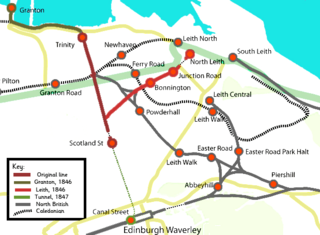
The Edinburgh, Leith and Newhaven Railway was a railway company formed in 1836 to connect the city of Edinburgh with the harbours on the Firth of Forth. When the line connected to Granton, the company name was changed to the Edinburgh, Leith and Granton Railway. It opened part of its route in 1846, but reaching the centre of Edinburgh involved the difficult construction of a long tunnel; this was opened in 1847. It was on a steep incline and was worked by rope haulage.

Constitution Street is a thoroughfare in Leith, Edinburgh, Scotland. It runs north from the junction of Leith Walk, Great Junction Street and Duke Street to the Albert Dock in Leith Docks.
Shandon is an area of Edinburgh within North Merchiston approximately three miles west of the centre of Edinburgh. It is bounded by Slateford Road to the north, Harrison Road to the east, the Union Canal to the south and the Glasgow-Edinburgh Shotts Line and Suburban rail lines to the west.
"The Singing Street", is a short film made in 1950 in Edinburgh, Scotland and first shown in 1951. It was created by a group of teachers from Norton Park School, who filmed some of their pupils playing street games, accompanied by traditional children's songs, at various locations in the city. It documented an oral tradition which has all but vanished in the decades since it was made.

Thomas Brown was a Scottish architect in the early 19th century based in Edinburgh. He is best known for St. Mary's Church, Bellevue, Edinburgh, usually known as Bellevue Church.

Eastwood is a residential neighbourhood in the city of Glasgow, Scotland. It is situated south of the River Clyde, and is part of the Newlands/Auldburn ward under Glasgow City Council.


