Leith Citadel railway station

Last updated

Leith Citadel
Leithcitadel.jpg
The station building today
General information
Location Leith, Edinburgh
Scotland
Other information
StatusDisused
History
Original company Edinburgh, Leith and Granton Railway
Pre-grouping North British Railway
Post-grouping London and North Eastern Railway
Key dates
10 May 1846Opened as North Leith
16 June 1947Closed to passengers
1952Renamed Leith Citadel
1968Line closed for freight

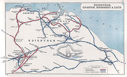
Leith Citadel, renamed in 1952 from North Leith, was an early railway terminus in Leith, Scotland. It was on Commercial Street, near the Leith Docks.

Contents

History

Map showing Edinburgh railways in 1905. Leith Citadel is named North Leith Edinburgh- Granton- Haymarket & Leith RJD 27.jpg
Map showing Edinburgh railways in 1905. Leith Citadel is named North Leith

The Edinburgh, Leith and Granton Railway constructed a branch to North Leith (Leith Citadel) which was opened on 10 May 1846. It served as a terminus in terms of passenger traffic but a freight-only branch on its west side continued into Leith Docks.

It was designed by Grainger & Miller and being one of the earliest railway structures it adopts a Georgian rather than "Victorian railway" style. [1]

It closed (except for the side branch) in 1947. [2] It was converted into a pub called the "Steamboat Inn" around 1950 which closed around 1980 when it was then restored by the Scottish Development Agency as one of the "Leith Project" schemes for community use.

Today

Leith Citadel station is a Category B listed building and is one of the remaining structures from the original line. It is now used as the Citadel Youth Centre. [3] [4]

Related Research Articles

<span class="mw-page-title-main">Leith</span> Port district of Edinburgh, Scotland

Leith is a port area in the north of the city of Edinburgh, Scotland, founded at the mouth of the Water of Leith. In 2021, it was ranked by Time Out as one of the top five neighbourhoods to live in the world.

<span class="mw-page-title-main">Newhaven, Edinburgh</span> Suburb of Edinburgh, Scotland

Newhaven is a district in the City of Edinburgh, Scotland, between Leith and Granton and about 2 miles (3.2 km) north of the city centre, just north of the Victoria Park district. Formerly a village and harbour on the Firth of Forth, it had a population of approximately 5,000 inhabitants at the 1991 census. Newhaven was designated a conservation area, one of 40 such areas in Edinburgh, in 1977.

<span class="mw-page-title-main">Caledonian Railway</span> British pre-grouping railway company

The Caledonian Railway (CR) was a major Scottish railway company. It was formed in the early 19th century with the objective of forming a link between English railways and Glasgow. It progressively extended its network and reached Edinburgh and Aberdeen, with a dense network of branch lines in the area surrounding Glasgow. It was absorbed into the London, Midland and Scottish Railway in 1923. Many of its principal routes are still used, and the original main line between Carlisle and Glasgow is in use as part of the West Coast Main Line railway.

<span class="mw-page-title-main">Craiglockhart</span>

Craiglockhart is a suburb in the south west of Edinburgh, Scotland, lying between Colinton to the south, Morningside to the east Merchiston to the north east, and Longstone and Kingsknowe to the west. The Water of Leith is also to the west.

<span class="mw-page-title-main">Bonnington, Edinburgh</span>

Bonnington is a district of Edinburgh, the capital of Scotland. The area centres upon an original village which grew up around a ford on the Water of Leith on the old boundary between Edinburgh and the port of Leith. Before the creation of Leith Walk the road via the villages of Broughton and Bonnington, or Wester Road as it appears on some old maps, was one of two roads formerly connecting Edinburgh to Leith; the other being Easter Road. The district lies between the districts of Pilrig and Newhaven.

Easter Road is an arterial road in north Edinburgh, the capital of Scotland. The road is so called as it was known as the "Easter (eastern) road to Leith". As maps of Edinburgh in the late 18th century show, it had a counterpart in "Wester Road". Until the creation of Leith Walk in the middle of the 17th century these were the two main routes from Leith to Edinburgh. Historic personages who have ridden up Easter Road have included Mary, Queen of Scots (1561) and Oliver Cromwell.

The Edinburgh Suburban and Southside Junction Railway was a railway company that built an east-west railway on the southern margin of Edinburgh, Scotland, primarily to facilitate the operation of heavy goods and mineral traffic across the city. The line opened in 1884. Although its route was rural at the time, suburban development quickly caught up and passenger carryings on the line were buoyant; the passenger service operated on a circular basis through Edinburgh Waverley railway station.

<span class="mw-page-title-main">Great Junction Street</span>

Great Junction Street is a street in Leith, on the northern outskirts of Edinburgh, Scotland. It runs southeast to northwest following approximately the southwestmost line of the old town walls around Leith.

<span class="mw-page-title-main">Leith Central railway station</span> Former railway station in Leith, Scotland

Leith Central Railway Station was a railway station in Leith, Scotland. It formed the terminus of a North British Railway branch line from Edinburgh Waverley. The station was built on a large scale, and it included a trainshed over the platforms.

<span class="mw-page-title-main">Leith Walk</span> Street in Edinburgh, Scotland

Leith Walk is one of the longest streets in Edinburgh, Scotland, and is the main road connecting the centre of the city to Leith. Forming most of the A900 road, it slopes downwards from Picardy Place at the south-western end of the street to the 'Foot of the Walk' at the north-eastern end, where Great Junction Street, Duke Street, Constitution Street and the Kirkgate meet.

<span class="mw-page-title-main">St Leonards railway station (Scotland)</span> Former railway station in Scotland

St. Leonards railway station is a closed railway station in St Leonard's, Edinburgh, on the Edinburgh and Dalkeith Railway. It was Edinburgh's first railway station. The railway was built in 1831 to transport coal from the mining towns south of the city; and the following year opened passenger services. St. Leonards was the terminus for the south of the city and was named after the nearby region.

<span class="mw-page-title-main">Edinburgh, Leith and Newhaven Railway</span> Former railway line in Scotland

The Edinburgh, Leith and Newhaven Railway was a railway company formed in 1836 to connect the city of Edinburgh with the harbours on the Firth of Forth. When the line connected to Granton, the company name was changed to the Edinburgh, Leith and Granton Railway. It opened part of its route in 1846, but reaching the centre of Edinburgh involved the difficult construction of a long tunnel; this was opened in 1847. It was on a steep incline and was worked by rope haulage.

The Balerno line was a short loop railway in Scotland. It was some 6 miles in length leaving the main Caledonian Edinburgh to Carstairs line at Slateford in Edinburgh. It was built by the Caledonian Railway (CR) mainly to service the many enterprises situated along the upper Water of Leith. However, passenger trains also ran. Most trains terminated at Balerno, though they had to travel to Ravelrig to turn round. Other stations were constructed at Colinton, Juniper Green and Currie. In 1923, with the grouping, the CR amalgamated with several other companies to form the London, Midland and Scottish Railway (LMS) which, following nationalisation in 1947, became part of British Railways.

<span class="mw-page-title-main">Tally Toor</span> Martello tower in Leith, Edinburgh, Scotland

The Tally Toor is the local name for a Martello tower in Leith, Edinburgh, Scotland. It is one of Scotland's three Martello towers, the other two being at Hackness and Crockness in Orkney. Originally built offshore on a rocky outcrop called the Mussel Cape Rocks, the land around it was subsequently reclaimed, and the building now lies, half-buried, in an industrial area on the eastern breakwater of Leith Docks.

The Caledonian Railway lines to Edinburgh started with the main line that reached Edinburgh in 1848 as part of its route connecting the city with Glasgow and Carlisle. The potential of the docks at Granton and Leith led to branch line extensions, and residential development encouraged branch lines in what became the suburbs of Edinburgh. In 1869 a line was opened from Carfin through Shotts giving the Caledonian a shorter route between Glasgow and Edinburgh.

<span class="mw-page-title-main">Victoria Park, Edinburgh</span>

Victoria Park is a district in north Edinburgh south of Newhaven and lying between Trinity and Leith. The area was given Conservation Area status in March 1998.

<span class="mw-page-title-main">Colinton railway station</span> Former railway station in Scotland

Colinton railway station was opened in 1874 and served the area of the then village of Colinton that now forms part of the city of Edinburgh, with Colinton House nearby. Although primarily built as a goods line to serve the many mills on the Water of Leith, a passenger service was provided by the Caledonian Railway using the Balerno Loop and after grouping by the London, Midland and Scottish Railway, seeing formal closure to passenger traffic shortly after nationalisation.

<span class="mw-page-title-main">Juniper Green railway station</span> Former railway station in Scotland

Juniper Green railway station was opened in 1874 and served the area of the then village of Juniper Green that now forms part of the city of Edinburgh. Although primarily built as a goods line to serve the many mills on the Water of Leith, a passenger service was provided by the Caledonian Railway using the Balerno Loop and after grouping by the London, Midland and Scottish Railway, seeing formal closure to passenger traffic shortly after nationalisation. The station lay in rural surroundings despite being only a short distance from the centre of Edinburgh and had been popular with families having a day out in the country.

<span class="mw-page-title-main">Waverley Steps</span>

Waverley Steps is a stair link of unique character linking Princes Street to Waverley station, an essential pedestrian route in the centre of Edinburgh.

The Shore in Leith is a historic and picturesque street in the centre of Old Leith the harbour area of Edinburgh. It edges the final section of the Water of Leith before it flows through Leith Docks into the sea.

References

  1. Buildings of Scotland: Edinburgh by Gifford, McWilliam and Walker
  2. "Railways - Leith Stations".
  3. "Citadel Youth Centre". Citadel Youth Centre. Retrieved 11 September 2013.
  4. "Leith Citadel Station, Now Citadel Youth Centre (photos)". Edinphoto. 25 May 2006. Retrieved 11 September 2013.
Preceding station Disused railways Following station
Junction Road / Junction Bridge   North British Railway
Edinburgh, Leith and Granton Line
 Terminus

Coordinates: 55°58′38″N3°10′33″W / 55.9773°N 3.1759°W / 55.9773; -3.1759