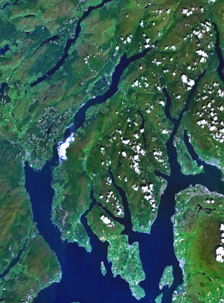
The Islands of the Firth of Clyde are the fifth largest of the major Scottish island groups after the Inner and Outer Hebrides, Orkney and Shetland. They are situated in the Firth of Clyde between Argyll and Bute in the west and Inverclyde, North Ayrshire and South Ayrshire in the east. There are about forty islands and skerries. Only four are inhabited, and only nine are larger than 40 hectares. The largest and most populous are Arran and Bute. They are served by dedicated ferry routes, as are Great Cumbrae and Holy Island. Unlike the isles in the four larger Scottish archipelagos, none of the isles in this group are connected to one another or to the mainland by bridges.

Argyll and Bute is one of 32 unitary council areas in Scotland and a lieutenancy area. The current lord-lieutenant for Argyll and Bute is Jane Margaret MacLeod. The administrative centre for the council area is in Lochgilphead at Kilmory Castle, a 19th-century Gothic Revival building and estate. The current council leader is Councillor Jim Lynch.

The Firth of Clyde, is the estuary of the River Clyde, on the west coast of Scotland. The Firth has some of the deepest coastal waters of the British Isles. The Firth is sheltered from the Atlantic Ocean by the Kintyre Peninsula. The Firth lies between West Dunbartonshire in the north, Argyll and Bute in the west and Inverclyde, North Ayrshire and South Ayrshire in the east. The Kilbrannan Sound is a large arm of the Firth, separating the Kintyre Peninsula from the Isle of Arran. The Kyles of Bute separates the Isle of Bute from the Cowal Peninsula. The Sound of Bute separates the islands of Bute and Arran.

Dunoon is the main town on the Cowal Peninsula in the south of Argyll and Bute, west of Scotland. It is located on the western shore of the upper Firth of Clyde, to the south of the Holy Loch and to the north of Innellan. As well as forming part of the council area of Argyll and Bute, Dunoon also has its own community council. Dunoon was a burgh until 1976.
Cowal is a rugged peninsula in Argyll and Bute, on the west coast of Scotland. It is connected to the mainland to the north, and is bounded by Loch Fyne to the west, by Loch Long and the Firth of Clyde to the east, and by the Kyles of Bute to the south.

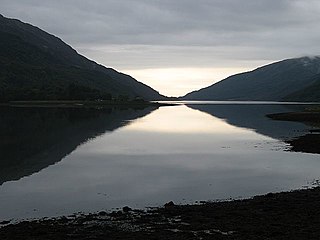
Loch Fyne, is a sea loch off the Firth of Clyde and forms part of the coast of the Cowal Peninsula. Located on the west coast of Argyll and Bute, west of Scotland. It extends 65 kilometres (40 mi) inland from the Sound of Bute, making it the longest of the sea lochs in Scotland. It is connected to the Sound of Jura by the Crinan Canal. Although there is no evidence that grapes have grown there, the title is probably honorific, indicating that the river, Abhainn Fìne, was a well-respected river.

Sandbank is a village on the Cowal peninsula in Argyll and Bute, Scotland. It is located 2.5 miles north of Dunoon on the coastal A815 or the inland A885. It sits on the southern shore of the Holy Loch, a sea loch of the Firth of Clyde.

Tarbert is a village in the west of Scotland, in the Argyll and Bute council area. It is built at the head of an inlet of Loch Fyne called East Loch Tarbert, on a narrow isthmus which connects Kintyre to the south with Knapdale to the north and separates East Loch Tarbert from the much longer West Loch Tarbert. Tarbert had a recorded population of 1,338 in the 2001 Census.

The Forth and Clyde canal pathway runs between the Firth of Forth and the Firth of Clyde and is a 106-kilometre-long (66 mi) footpath and cycleway that runs across Scotland, between Bowling, west of Glasgow, and Lochrin Basin in Edinburgh. The path runs on the towpaths of the Forth & Clyde and Union Canals and is entirely off-road. The path is well maintained and its surface is generally good, although there are some stretches particularly between Falkirk and the outskirts of Edinburgh where wet weather leads to muddy conditions unsuitable for road intended bicycles. It is well used by walkers and cyclists, and designated as one of Scotland's Great Trails by NatureScot. It also forms part of the National Cycle Network, being designated as Route 754. Sustrans advises that the path is best followed from the Clyde to the Forth because the prevailing wind is from the south west. Much of the path is also suitable for experienced horseriders, although in some places low bridges, narrow aqueducts and gates may restrict access for horses.

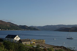
Portavadie is a village on the shores of Loch Fyne on the coast of the Cowal Peninsula, in Argyll and Bute, West of Scotland.
Tighnabruaich; is a village on the Cowal Peninsula, on the western arm of the Kyles of Bute in Argyll and Bute, west of Scotland. In 2011 the population was 660. It is west of Glasgow and north of the Isle of Arran.
The Hillend Loch Railway Path, also known as the Airdrie to Bathgate Railway Path, is a rail trail located in central Scotland. The path is approximately 14 miles (23 km) long and follows the route of the former Bathgate and Coatbridge Railway between Airdrie, North Lanarkshire (55.8662°N 3.9539°W), and Bathgate, West Lothian (55.8918°N 3.6224°W).

Caldercruix railway station serves the village of Caldercruix in North Lanarkshire, Scotland. It is managed by ScotRail and is on the North Clyde Line. Originally opened by the Bathgate and Coatbridge Railway in 1862, it was closed in 1956 then reopened in 2011 as part of the reopening of the Airdrie–Bathgate rail link.

West Coast Motors is a bus, coach and ferry operator, based in Campbeltown, Scotland. The company also operates under the name Borders Buses in the Scottish Borders and formerly under the Glasgow Citybus brand in Greater Glasgow.
Kames is a small village on the Cowal Peninsula, in Argyll and Bute, west of Scotland, on the shore of the west arm of the Kyles of Bute.

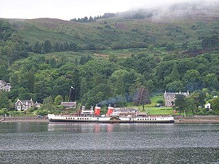
MV Juno was a passenger and vehicle ferry operated by Caledonian MacBrayne on the Firth of Clyde, Scotland between 1974 and 2007. She was the middle of three vessels nicknamed "streakers", the first in the Calmac fleet to be fitted with Voith Schneider Propellers. Juno left service in early 2007 and was laid up at Rosneath for 4 years. On 18 May 2011, she was beached there for scrapping and was gone by the end of July.
Ardtaraig is a hamlet lying at the head of Loch Striven on the Cowal Peninsula, in Argyll and Bute, West of Scotland. The hamlet is on the single track B836 road.

Millhouse is a village in the parish of Kilfinan. Located on the B8000 inland from Kames in the east and Portavadie in the west, on the Cowal Peninsula, in Argyll and Bute, west of Scotland.

The 478 is a bus route in Argyll and Bute, Scotland, which runs between Dunoon and Portavadie via Tighnabruiach and Kames. It is operated by West Coast Motors, which was established in 1921. Strathclyde Partnership for Transport inaugurated the route, along with that of the 477 and 479, in October 1993. The route is noted for its long stretches of single-track roads with scattered passing places, especially along the B836 between Sandbank and Auchenbreck, at the junction with the A886 Colintraive–to–Strachur road. The drivers of the 477, 478 and 479 have dubbed their routes the "Bermuda Triangle" due to their complexity and remoteness.