National Cycle Route 23

Last updated

National Cycle Route 23 (or NCR 23) is a route of the National Cycle Network , running from Reading to Sandown . The partially signed route passes through Basingstoke, Eastleigh and Southampton; once across the Solent, it continues through Cowes and Newport.

Contents

Route

Reading to Basingstoke

Reading | Basingstoke

map

Basingstoke to Alton/Winchester

Basingstoke | Alton | Winchester

map

Winchester to Southampton

Winchester | Eastleigh | Southampton [1]

Hockley Viaduct Hockley Railway Viaduct.jpg
Hockley Viaduct

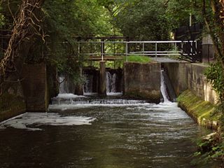
From Winchester City Mill, the route follows the towpath of the River Itchen through the grounds of Wolvesey Castle before emerging onto College Walk close to the junction with College Street, the location of Winchester College. The route follows College Walk across the river, turns right onto Domum Road and then continues onto the old track bed of the Didcot, Newbury and Southampton Railway alongside the Itchen Navigation, eventually reaching the Hockley Viaduct. This was the last part of NCR 23 to be opened, following a lengthy restoration programme. It was opened to the public in February 2013 by track cyclist Dani King. [2]

South of the viaduct, NCR 23 loops northwards alongside the South West Main Line, crossing the railway and the Hockley Link road before joining Otterbourne Road. The route follows this road through the villages of Compton, Shawford and Otterbourne, then turns left onto Boyatt Lane which takes it into Boyatt Wood. The route follows a cycle path alongside Woodside Avenue through the suburb, crossing into Passfield Avenue in Eastleigh. Towards the end of Passfield Avenue, NCR 23 turns right onto Nightingale Avenue where it meets National Cycle Route 24. NCR 24 heads north along Magpie Lane but NCR 23 continues south to Chestnut Avenue where it turns right, then left onto Stoneham Lane.

NCR 23 passes through this ford, but the footbridge presents an alternative route Monks Brook at Doncaster Drove.jpg
NCR 23 passes through this ford, but the footbridge presents an alternative route

NCR 23 follows a cycle path alongside Stoneham Lane until it reaches North Stoneham House having passed the Concorde Club. At this point NCR 23 swings left, crossing Stoneham Lane and through a ford of Monks Brook on Doncaster Drove. The route follows the lane between Lakeside Country Park to the north and the University of Southampton sports ground to the south, emerging at Wide Lane to follow a shared use path alongside the road. The route continues to follow Wide Lane southwards, past Southampton Airport (Parkway) railway station and the site of the former Ford Transit factory, reaching the A27 road at a roundabout.

NCR 23 crosses the A27 and heads south through Monksbrook Greenway, an area of woodland that once formed the grounds of The Grange, a country house that was located near the road. NCR 23 then makes its way through the Southampton suburb of Mansbridge, travelling along several residential streets before emerging onto Mans Bridge itself, which the route crosses and turns right into Riverside Park. The route follows the towpath through the park, crossing the road at Woodmill and continuing the other side, eventually reaching the Cobden Bridge at the southern extremity of Riverside Park. The route follows the road across the bridge from Bitterne Park to St Denys, taking the first turning left into Priory Road and passing through the site of St Denys Priory, now a residential area. Towards the end of Priory Road the route turns left onto Horseshoe Bridge, leaving the road just before the bridge crosses the railway line.

From here, NCR 23 travels along a shared use boardwalk alongside the tidal section of the River Itchen, then leaves the boardwalk to pass through a small industrial area to reach Radcliffe Road, which it follows until it reaches the A3024 road in Northam. The cycle route crosses the dual carriageway A3024 and crosses the railway near the site of Northam railway station within view of St Mary's Stadium. The route heads through the suburb of St Mary's and westwards into Southampton City Centre, reaching Above Bar Street where the route turns south into the pedestrianised shopping area and on to the Bargate.

The route continues past the Bargate, heading directly south along the High Street and on to Town Quay, where the Red Funnel ferry terminal is located. The route continues on the other side of the Solent..

Cowes to Sandown

Traffic sign for NCR 23 on the Isle of Wight National Cycle Network route 23 sign to Newport.JPG
Traffic sign for NCR 23 on the Isle of Wight
NCR 23, south of Merstone. NCN23-overbridge.jpg
NCR 23, south of Merstone.

East Cowes | Cowes | Newport | Sandown [3]

Upon arrival at East Cowes, one must continue ahead around the one-way system in order to reach the Cowes Floating Bridge, which allows the route to cross the River Medina. There is a £1 return toll for cyclists, [4] and a 2-3 minute crossing brings you to Cowes. The Floating Bridge does not operate a 24-hour service, so this section of the route is not available during late night.

A short distance along the Ferry Road takes you to the junction with Arctic Road, where the cycle route turns to the left, away from the coast. At the end of Arctic Road, past the industrial estate, the route leaves road for the first time on the Island. A short ascent takes you onto the first cyclepath built on the Island, the Cowes to Newport Cyclepath. This route was constructed on the old railway trackbed of the Southern Railway's Cowes to Newport section. Towards Newport, the route crosses an inlet of the River Medina, which the route follows all the way to Newport.

The Cyclepath turns to the left at the edge of the Riverway Industrial Estate, near Newport town centre. From there, there are signs that direct the cyclist towards the Town Quay and along cycle lanes on the pavement of Coppins Bridge roundabout. After more signs, the cyclist finds a freshly tarmacked shared foot/cycle path which leads the route to Shide.

In Shide, the route joins the Sandown to Newport Cyclepath - this again follows the route of a disused railway line (with minor deviations) all the way to Sandown. The route initially follows the River Medina, now a small stream, across the main road at Blackwater. There is no traffic control at this flat crossing, but it is within a speed limited area. Beyond here, the route leaves the railway trackbed for about one mile, skirting neighbouring farmland, then returning to the old route in good time for Merstone.

The former station at Merstone consisted of a single island platform, which still stands. Past this is Merstone Lane, a narrow but heavily used road, which should be crossed with care. Shortly after this, the route passes under a road bridge and converges with the Sunshine Trail. The route then slopes significantly downhill, until it is parallel with the course of a different river, the Eastern Yar. Shortly after this, the route again leaves the railway trackbed for a short detour, caused by limited development along the route ahead. At this point, the surface changes from tarmac to planked duckboards, until reaching Horringford. At this point, the route crosses the main A3056 road, where a toucan crossing is provided.

The route then follows the old railway line across the Yar's floodplain until Langbridge, at the edge of Newchurch, where a slight deviation to the north is required, again due to development on the old route. Beyond Newchurch lies the village of Alverstone, with a final flat crossing with the minor road there before the route arrives at Sandown, on the edge of town between two holiday camp sites. The railway station and town centre can be reached by turning right onto the through road there then following the Sunshine Trail.

map

Related Research Articles

<span class="mw-page-title-main">M3 motorway (Great Britain)</span> Major motorway in England

The M3 is a motorway in England, from Sunbury-on-Thames, Surrey, to Eastleigh, Hampshire; a distance of approximately 59 miles (95 km). The route includes the Aldershot Urban Area, Basingstoke, Winchester, and Southampton.

<span class="mw-page-title-main">Borough of Eastleigh</span> Non-metropolitan borough in England

The Borough of Eastleigh is a local government district and borough in Hampshire, England, bordering the unitary authority of Southampton, Test Valley, the City of Winchester and the Borough of Fareham. Eastleigh is separated from the New Forest by Southampton Water. Water bounds much of the borough, with Southampton Water and the River Hamble bordering the east and southwest of the district. The built-up nature of neighbouring Southampton and the urban area around the town of Eastleigh contrast with the rural nature of much of the borough, which lies within the Hampshire Basin.

<span class="mw-page-title-main">River Itchen, Hampshire</span> River in Hampshire, England

The River Itchen in Hampshire, England, rises to the south of New Alresford and flows 26 miles (42 km) to meet Southampton Water below the Itchen Bridge. The Itchen Navigation was constructed in the late 17th and early 18th centuries to enable barges to reach Winchester from Southampton Docks, but ceased to operate in the mid-19th century and is largely abandoned today.

<span class="mw-page-title-main">U.S. Route 258</span> U.S. Highway in North Carolina and Virginia

U.S. Route 258 is a spur of US 58 in the U.S. states of North Carolina and Virginia. The U.S. Highway runs 220.15 miles (354.30 km) from US 17 Business and NC 24 Business in Jacksonville, North Carolina north to Virginia State Route 143 at Fort Monroe in Hampton, Virginia. In North Carolina, US 258 connects Jacksonville with the Inner Banks communities of Kinston, Snow Hill, Farmville, Tarboro, and Murfreesboro. The U.S. Highway continues through the Virginia city of Franklin, where the highway intersects US 58, and the town of Smithfield on its way to the Hampton Roads metropolitan area. US 258 crosses the James River on the James River Bridge and follows Mercury Boulevard through Newport News and Hampton.

The Isle of Wight Central Railway (IoWCR) was a railway company on the Isle of Wight, United Kingdom. It was formed in 1887 by the merging of three earlier railways, the Cowes and Newport Railway, the Ryde and Newport Railway and the Isle of Wight Railway,.

<span class="mw-page-title-main">Virginia State Route 32</span> Primary state highway in the US

State Route 32 is a primary state highway in the U.S. state of Virginia. The state highway runs 38.89 miles (62.59 km) from the North Carolina state line in Suffolk north to U.S. Route 17, US 258, and SR 143 in Newport News. The southernmost part of SR 32 connects Suffolk with the Albemarle Region of North Carolina via North Carolina Highway 32. The remainder of SR 32 runs concurrently with at least one other state or U.S. Highway between Suffolk and Newport News, including US 13, SR 10, US 258, and US 17. The last two highways run together with SR 32 on the James River Bridge.

<span class="mw-page-title-main">Itchen Way</span> Long-distance footpath in Hampshire, England

The Itchen Way is a 31.80-mile (51.18 km) long-distance footpath following the River Itchen in Hampshire, England, from its source near Hinton Ampner House to its mouth at Woolston. The walk finishes at Sholing railway station. The route has been promoted by the Eastleigh Group of the Ramblers with grant aid from Hampshire County Council and Eastleigh Borough Council. The route was altered and improved in 2008.

<span class="mw-page-title-main">Castleman Trailway</span> Footpath in Southern England

The Castleman Trailway is a footpath in Southern England. Portions of the trailway are also used as a cyclepath but the middle section from East Wimborne to the River Allen bridge is not cyclable.

<span class="mw-page-title-main">Monks Brook</span> River in Hampshire, England

Monks Brook is a river in the English county of Hampshire. It is a tributary of the River Itchen, which it joins at a medieval salmon pool in Swaythling. The brook is formed from seven streams that rise in the chalky South Downs, with the official source of Monks Brook being known as Bucket's Corner. Monks Brook drains a clay catchment of 49 square kilometres (19 sq mi). The brook is designated a main river, which means the operating authority for managing it is the Environment Agency, not the local government authorities for the areas through which the river runs.

<span class="mw-page-title-main">U.S. Route 17 in Virginia</span> State highway in Virginia

U.S. Route 17 is a part of the U.S. Highway System that runs from Punta Gorda, Florida to Winchester, Virginia. In Virginia, the U.S. Highway runs 255.83 miles (411.72 km) from the North Carolina state line in Chesapeake north to its northern terminus at US 11, US 50, and US 522 in Winchester. US 17 is a major highway in the eastern half of Virginia. The U.S. Highway connects the Albemarle Region of North Carolina with the Hampton Roads metropolitan area. Within the urban area, US 17 passes through the South Hampton Roads cities of Chesapeake, Portsmouth, and Suffolk and the Virginia Peninsula city of Newport News. Between Yorktown and Fredericksburg, the U.S. Highway serves as the primary highway of the Middle Peninsula. At Fredericksburg, US 17 leaves the Atlantic coastal plain; the highway passes through the Piedmont town of Warrenton and crosses the Blue Ridge Mountains on its way to Winchester in the Shenandoah Valley.The route from Tappahannock to Winchester roughly follows the Confederate March during the Civil War to Gettysburg.

<span class="mw-page-title-main">Merstone</span> Human settlement in England

Merstone is a hamlet on the Isle of Wight. It is home to Merston Manor, built in 1605 in the Jacobean style by Edward Cheeke, and rebuilt in the Victorian era. Merston Manor was first mentioned in the Domesday Book, and the present structure is arguably the oldest brick house on the Island. Prior to the Norman Conquest, Merston Manor was owned by the Brictuin family. The manor now belongs to the Crofts family. According to the Post Office the population of the hamlet was at the 2011 Census included in the civil parish of Arreton.

<span class="mw-page-title-main">National Cycle Route 4</span> Cycle route in the United Kingdom

National Cycle Route 4 is a route of the National Cycle Network, running from London to Fishguard, Pembrokeshire. Between these, the route runs through Reading, Bath, Bristol, Newport, Swansea and St David's. Within Wales, sections of the route follow branches of the Celtic Trail cycle route.

<span class="mw-page-title-main">National Cycle Route 1</span> Cycle route in the United Kingdom

National Cycle Route 1 is a route of the National Cycle Network, running from Dover to Tain. The 1,264 mi-long (2,034-kilometre) cycle-path is located in the United Kingdom.

<span class="mw-page-title-main">St Lawrence railway station (Isle of Wight)</span> Former railway station in Isle of Wight, UK

St Lawrence railway station is a former railway station in the village of St Lawrence on the Isle of Wight.

National Cycle Route 51 is an English long distance cycle route running broadly east-west connecting Colchester and the port of Harwich to Oxford via Ipswich, Bury St Edmunds, Cambridge, Bedford, Milton Keynes, Bicester, and Kidlington.

National Cycle Route 78 runs from Campbeltown to Inverness. It was officially launched as the Caledonia Way in 2016 as part of the wider redevelopment of Scotland's cycle network. It runs from the Kintyre peninsula to the Great Glen and the route varies from on road to traffic-free forest trails and canal paths.

<span class="mw-page-title-main">Railways on the Isle of Wight</span> Railways

There once existed a 55+12-mile (89.3 km) network of railway lines on the Isle of Wight, which operated both as a self-contained railway network, and as links to ferry services between the island and the South coast of Great Britain. The routes were opened by several companies between 1862 and 1901 and modernised after The Grouping in the 1920s. Most of them were permanently closed between 1952 and 1966, whilst the 8+12-mile-long (13.7 km) Island Line was temporarily closed in 1966 and rebuilt for electric train services, introduced in 1967. Replacement trains were introduced in 1990, and again in 2021 along with a major renewal of the line. A further 5+12 miles (8.9 km) have reopened as a heritage line known as the Isle of Wight Steam Railway and there have been several proposals to expand the network further since the 1960s, either with conventional heavy rail or by conversion to light rail.

<span class="mw-page-title-main">Bike paths in Sydney</span> Bike paths

Bike paths in Sydney, New South Wales, Australia, vary widely, with the majority either shared cycle and pedestrian paths or on road paths, and a small number of separated cycleways. In 2009 the Sydney Morning Herald reported that "Sydney's cycleways are not so much an organised network as a fragmented collection of winding paths and half-finished ideas. Most were built or designed when cycling was viewed as a pleasant pastime rather than a practical form of travel and are now poorly suited to commuting."

The Djerring Trail is a shared use path that runs alongside the Cranbourne and Pakenham railway lines in south-eastern Melbourne, Australia. The route serves a total of 13 railway stations.

References

  1. "Route 23 - Map". Sustrans. Retrieved 27 October 2017.
  2. "National Cycle Network Route 23". Winchester City Council. Retrieved 27 October 2017.
  3. Route 4: Cowes - Sandown (via Newport and Alverstone)
  4. "Prices, Tickets for the Cowes Floating Bridge, IOW". Cowes Floating Bridge Ticket Prices. Retrieved 9 June 2016.