
National Cycle Route 24, otherwise known as the Colliers Way currently runs from Dundas Aqueduct to Frome via Radstock, [1] although it is intended to provide a continuous cycle route from Bristol and South Wales to Southampton and Portsmouth.
National Cycle Route 24, otherwise known as the Colliers Way currently runs from Dundas Aqueduct to Frome via Radstock, [1] although it is intended to provide a continuous cycle route from Bristol and South Wales to Southampton and Portsmouth.

The route follows a mixture of low traffic roads and old railway lines serving the Somerset coalfield. [2] [3]
There is a visitor centre, cycle shop and cafe at Dundas Aqueduct, where this route meets NCR 4 on the Kennet & Avon Canal. From there it follows a road to Midford. The next section proceeds to Wellow and then past Peasedown St John and Foxcote to Radstock. It then follows an old railway line past Kilmersdon, Buckland Dinham and Mells to Great Elm. An interim route is then provided along lanes from Great Elm through Vallis Vale (among other less hilly routes) into Frome, as the continuous cycle path ends in Great Elm. The track running from Great Elm is still in use by the local quarries for distribution of locally mined limestone to national terminals. This factor means the cycle path legally couldn't continue along the tracks, unless they close to trains altogether. The tracks connect to the Bristol to Weymouth line, shared by passenger and freight transport.
The remains of apple cores thrown from train passengers have left the route with several apple trees. A programme of planting of apple and pear trees is now being undertaken to turn this into a linear orchard. A series of etched and enamelled copper plate signs which are being set into boulders along the route highlighting the names of Old English varieties.
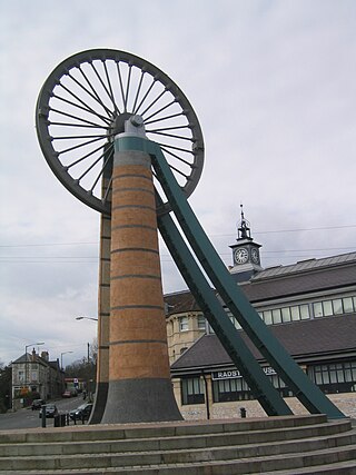
Radstock is a town and civil parish on the northern slope of the Mendip Hills in Somerset, England, about 9 miles (14 km) south-west of Bath and 8 miles (13 km) north-west of Frome. It is within the area of the unitary authority of Bath and North East Somerset. The Radstock built-up area had a population of 9,419 at the 2011 Census.

Buckland Dinham is a small village near Frome in Somerset, England. The village has a population of 381. The village's main industry is farming, but the village is also a dormitory village for the nearby cities of Bath and Bristol.

The Somerset and Dorset Joint Railway, also known as the S&D, SDJR or S&DJR, was an English railway line connecting Bath and Bournemouth, with a branch from Evercreech Junction to Burnham-on-Sea and Bridgwater. Strictly speaking, the main line ran from Bath Junction to Broadstone, as the line between Broadstone and Bournemouth was owned by the London and South Western Railway, while the line between Bath Junction and Bath was owned by the Midland Railway.

The Somerset Coal Canal was a narrow canal in England, built around 1800. Its route began in basins at Paulton and Timsbury, ran to nearby Camerton, over two aqueducts at Dunkerton, through a tunnel at Combe Hay, then via Midford and Monkton Combe to Limpley Stoke where it joined the Kennet and Avon Canal. This link gave the Somerset coalfield access east toward London. The longest arm was 10.6 miles (17.1 km) long with 23 locks. From Midford an arm also ran via Writhlington to Radstock, with a tunnel at Wellow.

Midford is a village approximately 3 miles (5 km) south-south-east of Bath, Somerset, England. Although relatively small, it extends over 2 counties, is part of two unitary authorities and is part of five parishes. Although all five parishes extend very near to the village centre, most of the residents reside in the parish of Southstoke and are part of the Bath and North East Somerset unitary authority.

Wellow is a village and civil parish in Somerset, England, about 5 miles (8.0 km) south of Bath. The parish, which includes the hamlets of Twinhoe, White Ox Mead, Baggridge and part of Midford has a population of 529. The village itself falls within the southernmost boundary of the Cotswolds Area of Outstanding Natural Beauty and is recognised as having special architectural and historic interest, which led to it being designated as a Conservation Area in 1983.

Kilmersdon is a village and civil parish on the north eastern slopes of the Mendip Hills in Somerset between the towns of Radstock and Frome. It is located on the B3139 between Wells and Trowbridge in Wiltshire. The settlement is recorded in William I's Domesday book and dates back at least 1,000 years; though the core of the village dates from the mid nineteenth century. The parish includes the hamlets of Charlton, South View and Green Parlour.

The Wrington Vale Light Railway was a railway from Congresbury on the Cheddar Valley line to Blagdon, and serving villages in the Yeo Valley, North Somerset, England. Construction of the line started in 1897 and it opened in 1901. Never more than a purely local line, it closed to passengers in 1931, and completely in 1963.
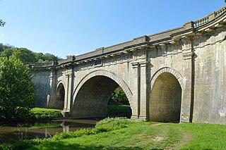
Dundas Aqueduct carries the Kennet and Avon Canal over the River Avon and the Wessex Main Line railway from Bath to Westbury. The aqueduct is near Monkton Combe, Somerset, and is about 2+1⁄2 miles (4 km) southeast of the city of Bath.

The Wellow Brook is a small river in Somerset, England.
The Somerset Coalfield in northern Somerset, England is an area where coal was mined from the 15th century until 1973. It is part of a larger coalfield which stretched into southern Gloucestershire. The Somerset coalfield stretched from Cromhall in the north to the Mendip Hills in the south, and from Bath in the east to Nailsea in the west, a total area of about 240 square miles (622 km2). Most of the pits on the coalfield were concentrated in the Cam Brook, Wellow Brook and Nettlebridge Valleys and around Radstock and Farrington Gurney. The pits were grouped geographically, with clusters of pits close together working the same coal seams often under the same ownership. Many pits shared the trackways and tramways which connected them to the Somerset Coal Canal or railways for distribution.

Great Elm is a village and civil parish between Mells and Frome in the Mendip district of Somerset, England. The parish includes the hamlet of Hapsford.

Hemington is a village and civil parish 5.5 miles (8.9 km) north west of Frome, in the Mendip district of Somerset, England. It is located just off the A366 between Trowbridge and Radstock. The parish includes the villages of Hardington, Faulkland and Foxcote.

Frome railway station serves a largely rural area of the county of Somerset in England, and is situated in the town of Frome. The station is located on a 1.5 miles (2.4 km) long branch line which loops off the main line railway, which carries services on both the Reading to Taunton line and Bristol to Weymouth route. Most of the trains which take the loop line in order to serve Frome station are on the Bristol to Weymouth route, and most trains on the Reading to Taunton line by-pass the station on the main line. The station is 22.25 miles (36 km) south of Bath Spa on the Bristol to Weymouth line, it is owned by Network Rail and is operated by Great Western Railway.
The Wilts, Somerset and Weymouth Railway (WS&WR) was an early railway company in south-western England. It obtained Parliamentary powers in 1845 to build a railway from near Chippenham in Wiltshire, southward to Salisbury and Weymouth in Dorset. It opened the first part of the network but found it impossible to raise further money and sold its line to the Great Western Railway (GWR) in 1850.
The Bristol and North Somerset Railway was a railway line in the West of England that connected Bristol with Radstock, through Pensford and further into northern Somerset, to allow access to the Somerset Coalfield. The line ran almost due south from Bristol and was 16 miles (26 km) long.
The Mendip Way is an 80-kilometre (50 mi) long-distance footpath across the Mendip Hills from Weston-super-Mare to Frome. It is divided into two sections.

The earliest known infrastructure for transport in Somerset is a series of wooden trackways laid across the Somerset Levels, an area of low-lying marshy ground. To the west of this district lies the Bristol Channel, while the other boundaries of the county of Somerset are along chains of hills that were once exploited for their mineral deposits. These natural features have all influenced the evolution of the transport network. Roads and railways either followed the hills, or needed causeways to cross the Levels. Harbours were developed, rivers improved, and linked to sources of traffic by canals. Railways were constructed throughout the area, influenced by the needs of the city of Bristol, which lies just to the north of Somerset, and to link the ports of the far south-west with the rest of England.

The Reading–Taunton line is a major branch of the Great Western Main Line from which it diverges at Reading railway station. It runs to Cogload Junction where it joins the Bristol to Exeter and Penzance line.

Westfield is a settlement lying on the Fosse Way between Radstock and Midsomer Norton in Somerset, England. In 2011 it was raised to the status of a civil parish.
{{cite web}}: CS1 maint: archived copy as title (link)