The Pennine Cycleway is a Sustrans-sponsored route in the Pennines range in northern England, an area often called the "backbone of England". The route passes through the counties of Derbyshire, West Yorkshire, Lancashire, North Yorkshire, Cumbria and Northumberland. It is part of the National Cycle Network (NCN). Sustrans founder John Grimshaw calls it 'the best National Cycle Network route of the lot'.
Beighton railway station is a former railway station near the village of Beighton on the border between Derbyshire and South Yorkshire, England.

National Cycle Route 1 is a route of the National Cycle Network, running from Dover to Tain. The 1,264 mi-long (2,034-kilometre) cycle-path is located in the United Kingdom.
National Cycle Route 6 is a route of the National Cycle Network, running from London to the Lake District.

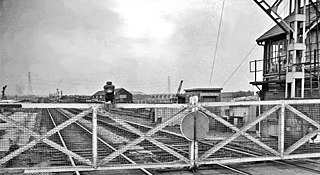
Shirebrook North railway station was a railway station serving the town of Shirebrook in Derbyshire, England. It was on the Lancashire, Derbyshire and East Coast Railway running from Chesterfield to Lincoln. The starion was also on the former Shirebrook North to Nottingham Victoria Line and the Sheffield District Railway. The station has since been demolished and housing now occupies parts of the site with some stub rails nearby serving a train scrapper.
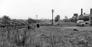
Boughton railway station served the village of Boughton in Nottinghamshire, England from 1897 to 1955 when it was closed. It has since been razed to the ground.

Fledborough railway station is a former railway station south west of Fledborough, Nottinghamshire, England.

Clifton-on-Trent railway station is a former railway station between North Clifton and South Clifton in eastern Nottinghamshire, England.

Doddington and Harby railway station is a former railway station on the Nottinghamshire border with Lincolnshire, England.
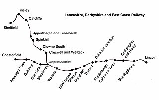
Skellingthorpe railway station is one of two former railway station in Skellingthorpe, Lincolnshire, England, on the border with Nottinghamshire.

The Way of the Roses is the newest of Great Britain's coast-to-coast, long-distance cycle routes and is based on minor roads, disused railway lines and specially constructed cycle paths. It lies entirely within the counties of Lancashire and Yorkshire, crossing the Yorkshire Dales and the Yorkshire Wolds in the north of England, passing through the historic cities of Lancaster and York and scenic towns and villages including Settle, Pateley Bridge and Ripon.
Pyewipe Junction engine shed was a motive power depot operated by the Great Eastern Railway (GER) located in Lincolnshire, England.

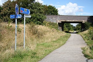
Fledborough Viaduct is a former railway viaduct near Fledborough, Nottinghamshire which is now part of the national cycle network.

National Cycle Network (NCN) Route 69 is a Sustrans National Route that runs from Hest Bank to Cleethorpes. The route is incomplete and consists of one long section in Lancashire, and seven short sections in West Yorkshire. The open sections are signed in both directions.

National Cycle Network (NCN) Route 65 is a Sustrans National Route that runs from Hornsea on the North Sea Coast of The East Riding of Yorkshire via Hull and York to Middlesbrough. It is fully open and signed.

National Cycle Network (NCN) Route 665 is a Sustrans route from Wetherby to South West York. Two sections of the route are open. As of summer 2020 the route is not fully signed. The central section between Tadcaster and Newton Kyme is still a proposal.
National Cycle Network (NCN) Route 64 is a Sustrans National Route that runs from Market Harborough to Lincoln. The route is 68 miles (109 km) in length and is fully open and signed in both directions. There are three sections to the route, NCN 63 and NCN 15 form the links between these sections.

The Bay Cycle Way is an 80-mile (130 km) cycling route around Morecambe Bay in Lancashire and Cumbria in north west England. Most of it forms National Cycle Route 700, while other sections are waymarked as NCN 6, NCN 69 and NCN 70.

National Cycle Network (NCN) Route 67 is a Sustrans National Route that runs from Long Whatton to Northallerton. The route is 124 miles (200 km) in length and is open but with sections missing.

