National Cycle Route 51

Last updated

National Cycle Route 51 is an English long distance cycle route running broadly east-west connecting Colchester and the port of Harwich to Oxford via Ipswich, Bury St Edmunds, Cambridge, Bedford, Milton Keynes, Bicester, and Kidlington.

Contents

Links to:

Forms part of the North Sea Cycle Route.

Route

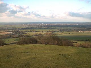
Colchester to Harwich

Colchester | Wivenhoe | Great Oakley | Harwich

This section runs from Colchester and National Cycle Route 1 to Harwich, where a seasonal foot ferry can be caught to Suffolk where the line continues.

For much of its length it is also the route of the North Sea Cycle Route, although this branches off at a park in Dovercourt to head to the Harwich International Port at Parkeston where there is access via ferry to the Continent.

At Harwich the signs indicate the route is 22 miles to Colchester, 3 to the International Port and 1 to Dovercourt. The North Sea Cycle Route junction is 1 mile along the route from Harwich to Colchester.

Harwich to Ipswich

Harwich | Felixstowe | Nacton | Ipswich

The route from Harwich to Felixstowe uses the Harwich Harbour Ferry (summer only, check timetable) to Langard Point offering an impressive view of The Port of Felixstowe.

On the Felixstowe side the ferry lands near Landguard Fort which is rich with history. The route then heads along the sea front into the centre of Old Felixstowe itself, a Victorian seaside town.

From Felixstowe the route heads out of town though a residential area and then mainly along minor roads towards Ipswich. There is a 1400-metre section of the official route takes one along a dedicated cycletrack very close to the A14. For this section there is an alternative route that uses a narrow single track road further away from the A14 which is also used by motorists and buses. The route then heads through Statton Hall, Levington and Nacton into Ipswich via Landseer Park, Holywells Park and the new waterfront area, where the routes crosses National Cycle Route 1.

Alternatively from Felixstowe one can take the RCR41 up the coast through the Suffolk Coast and Heaths Area of Outstanding Natural Beauty.

Ipswich to Bury St Edmunds

Ipswich | Needham Market | Stowmarket | Woolpit | Tostock | Thurston | Bury St Edmunds

This section of the route uses quiet roads passing the entrance to the Museum of East Anglian Life in Stowmarket, the village of Shelland and then through Thurston using a couple of off-road sections and finally into Bury St Edmunds using another section of off-road good cycle track running parallel with the road.

In late 2008/early 2009 part a section for the route west of Stowmarket was re-routed to take advantage of changes to the A14. It now uses a section of road that used to form the Eastbound carriageway of the A14 at Haughley Bends [1] and has been turned into a traffic free route for cyclists, walkers and horse riders as shown on the official map [2] of the works.

Bury St Edmunds to Cambridge

Bury St Edmunds | Newmarket | Burwell | Cambridge

Links to NCR 11 at Burwell and Cambridge

Cambridge to Bedford

NCR 51 route through Cambridge city centre Cambridge NCR51.png
NCR 51 route through Cambridge city centre

Cambridge | Girton | Swavesey | Huntingdon | Sandy | Bedford

NCR 51 leaves Cambridge crossing the A14 near Histon, routing north to St Ives adjacent to the Cambridgeshire Guided Busway, passing near Oakington and Swavesey, (adjacent to a guided bus route, no vehicles). Then via the old stone bridge from St Ives to Hemingford Abbots and Grey, then via Cow lane into Godmanchester and generally east towards Huntingdon railway station. [3]

At Huntingdon, it loses its identity, merging with NCR 12 (LondonGrimsby) as far as Great Barford (between Sandy and Bedford. [4]

From here, the route follows the trackbed of the old Varsity Line, now a rail trail, briefly joining the public highway at the village of Blunham, past Willington and the wetlands around Priory Marina, before arriving at the outskirts of Bedford where it follows the south bank of the River Great Ouse through parkland to the south end of Bedford Bridge.

Bedford to Milton Keynes

Bedford | Cranfield | Milton Keynes

Section from Marston Moretaine to Cranfield NCR 51 MarstonMoretane.JPG
Section from Marston Moretaine to Cranfield

From Bedford, the route follows the north bank of the River Great Ouse through town, passing under County Bridge at Prebend Street, and following a surfaced path along the river before crossing the river into Kempston at a footbridge. This section is prone to flooding, and an alternative cycle route is available by crossing County Bridge and following Prebend Street south to the Bedford Road cycleway.

NCR 51 follows a split cycle path (pedestrians/cycles separated by solid white line) through Kempston, past a supermarket, and through alleyways to Ridgeway School.

From the limits of Kempston, there is a well-marked route on roads, crossing the Bedford western bypass via Wootton to Marston Moretaine

The route travels through the Forest of Marston Vale (bike hire in the Forest centre) where there is a cycleway connecting with Millbrook railway station.

From the Forest of Marston Vale, NCR 51 takes residential roads, tracks, and bridleways to Cranfield

At Cranfield, there are no further NCR signs westbound until Salford, where the route crosses the M1 towards Wavendon and Woburn Sands (in the Milton Keynes Urban Area).

Cycleway network in Milton Keynes. NCR routes 6 and 51 are highlighted in red. (Openstreetmap.org) Milton Keynes Redway.gif
Cycleway network in Milton Keynes. NCR routes 6 and 51 are highlighted in red. (Openstreetmap.org)

Entering the eastern edge of Milton Keynes, the route follows Lower End Road (Wavendon) and then Walton Road (Wavendon Gate, Milton Keynes), then onwards along the Milton Keynes redway system (a segregated shared path (cycleway and footpath) network) around the south edge of Willen Lake (where there is some bike hire, tourist attractions etc.). A little further on (at the bottom of Campbell Park), it meets National Cycle Route 6 that leads to London and Northampton. Climbing through Campbell Park, it enters the central business district of Milton Keynes then follows Midsummer Boulevard down to Milton Keynes Central railway station.

NCR51 crosses a cattle grid in a sheep-grazed linear park in Milton Keynes NCR 51 MiltonKeynes east.JPG
NCR51 crosses a cattle grid in a sheep-grazed linear park in Milton Keynes

Milton Keynes to Oxford

Milton Keynes | Winslow | Bicester | Oxford

From Milton Keynes Central railway station, the route goes over the West Coast Main Line on a pedestrian/cycle bridge, and follows paved routes in parkland past the National Bowl and Furzton Lake to the A421 junction with Buckingham Road in West Bletchley. There is a cycleway here along Buckingham Road to link with Bletchley railway station.

Leaving Milton Keynes, the NCR 51 continues south-west along bridleways to Winslow. Onwards from Winslow, the route reaches Verney Junction and a little further on it interconnects with National Cycle Route 50 for Buckingham and Daventry. Minor roads then take it through Middle Claydon (from whence a short diversion may be made to Claydon House, a National Trust property). Next comes Steeple Claydon and then onwards to Bicester.

In Bicester, there are local routes to Bicester North railway station and Bicester Village railway station. Thereafter, a minor road beside the A41 takes it through Wendlebury, Weston on the Green, Bletchingdon, Kidlington, and then on into Oxford.

Related Research Articles

<span class="mw-page-title-main">St Neots</span> Human settlement in England

St Neots is a town in the Huntingdonshire District in Cambridgeshire, England. It lies about 50 miles (80 km) north of London and about 18 miles (29 km) west of Cambridge. The districts of Eynesbury, Eaton Ford and Eaton Socon were formerly independent but nowadays are considered merged into St Neots.

<span class="mw-page-title-main">A14 road (England)</span> Major road in England

The A14 is a major trunk road in England, running 127 miles (204 km) from Catthorpe Interchange, a major intersection at the southern end of the M6 and junction 19 of the M1 in Leicestershire to the Port of Felixstowe, Suffolk. The road forms part of the unsigned Euroroutes E24 and E30. It is the busiest shipping lane in East Anglia carrying anything from cars to large amounts of cargo between the UK and Mainland Europe.

The Oxford–Cambridge Arc is a notional arc of agricultural and urban land at about 80 kilometres radius of London, in south central England. It runs between the two English university cities of Oxford and Cambridge via Milton Keynes and other settlements in Bedfordshire, Buckinghamshire, Cambridgeshire, Northamptonshire, Oxfordshire at the northern rim of the London commuter belt. It is significant only in economic geography, with little physical geography in common.

<span class="mw-page-title-main">Bletchley railway station</span> Railway station in Milton Keynes, England

Bletchley is a railway station that serves the southern parts of Milton Keynes, England, and the north-eastern parts of Aylesbury Vale. It is 47 miles (75 km) northwest of Euston, about 32 miles (51 km) east of Oxford and 17 miles (27 km) west of Bedford, and is one of the seven railway stations serving the Milton Keynes urban area.

<span class="mw-page-title-main">Milton Keynes Central railway station</span> Principal railway station of Milton Keynes, England

Milton Keynes Central railway station serves Central Milton Keynes and the surrounding area of Milton Keynes, England. The station is located on the West Coast Main Line about 50 miles (80 km) northwest of London. The station is served by Avanti West Coast intercity services, and by West Midlands Trains regional services.

<span class="mw-page-title-main">Varsity Line</span> Historic Oxford–Cambridge railway

The Varsity Line was the main railway route that once linked the English university cities of Oxford and Cambridge, operated by the London and North Western Railway.

<span class="mw-page-title-main">A428 road</span> Road in England

The A428 road is a major road in central and eastern England. It runs between the cities of Coventry and Cambridge by way of the county towns of Northampton and Bedford. Together with the A421,, the eastern section of the A428 forms the route between Cambridge and Oxford. The A428 was formerly part of the main route from Birmingham to Felixstowe before the A14 was fully opened in 1993.

<span class="mw-page-title-main">Eastern Union Railway</span> Former English railway company

The Eastern Union Railway (EUR) was an English railway company, at first built from Colchester to Ipswich; it opened in 1846. It was proposed when the earlier Eastern Counties Railway failed to make its promised line from Colchester to Norwich. The businessman John Chevallier Cobbold and the engineer Peter Bruff were prominent in launching the company. The allied but nominally independent Ipswich and Bury Railway built a line onwards to Bury St Edmunds, also opening in 1846, and soon amalgamated with the EUR.

<span class="mw-page-title-main">A421 road</span> East-west road in southern England

The A421 is an important road for east/west journeys across south central England. Together with the A428, the A43 and A34, it forms the route from Cambridge through Milton Keynes to Oxford. The section between the A1 and the A5 is a national primary route.

<span class="mw-page-title-main">Milton Keynes redway system</span> Shared path network in Milton Keynes, England

The Milton Keynes redway system is an over 200 miles network of shared use paths for cyclists and pedestrians in Milton Keynes, Buckinghamshire, England. It is generally surfaced with red tarmac, and criss-crosses most of the city.

<span class="mw-page-title-main">Bicester Village railway station</span> Railway station in Oxfordshire, England

Bicester Village is one of two railway stations serving the town of Bicester in Oxfordshire. It is 12 miles (19 km) northeast of Oxford on the Oxford-Bedford line near its junction with the Chiltern Main Line. The renamed Bicester Village station reopened on 25 October 2015 with trains initially running between Oxford Parkway and London Marylebone. All trains serving it are operated by Chiltern Railways.

<span class="mw-page-title-main">National Cycle Route 1</span> Route of the National Cycle Network in the UK

National Cycle Route 1 is a route of the National Cycle Network, running from Dover to Tain. The 1,022 km-long (635-mile) cycle-path is located in the United Kingdom.

National Cycle Route 6 is a route of the National Cycle Network, running from London to the Lake District.

<span class="mw-page-title-main">Stagecoach East</span>

Stagecoach East is the divisional name for the bus operations of the Stagecoach Group in eastern England.

<span class="mw-page-title-main">Transport in Ipswich</span>

Ipswich is the county town of Suffolk, England. It is a medieval port and industrial town with a strong transport history; the urban area has a population of 122,000 and currently offers urban transport services for cars, cycles and buses. In addition there are 3 railway stations and regional coach services. London Stansted Airport is accessible by the airlink coach.

<span class="mw-page-title-main">Stagecoach X5</span> Bus service between Oxford and Bedford, England

Stagecoach X5 is an inter-urban bus service linking Oxford and Bedford via Bicester, Buckingham and Milton Keynes

<span class="mw-page-title-main">Transport in East Anglia</span>

Transport in East Anglia consists of extensive road and rail networks as well as one of England's key regional airports and the country's busiest container port. Despite having very little motorway within their borders, the counties of Suffolk, Norfolk and Cambridgeshire have modern transport links with the rest of the country.

The East Rugby League is a tier 5 amateur rugby league competition structure with sides from the East of England. It was previously the East Division of the Rugby League Conference, which was set up in 1997.

Transport in Bedford provides links between the town and other parts of England. Road access to the town is provided by the A6 & A421 roads, with the latter connecting the town with the M1 to the west and the A1 to the east via a bypass, with both being around 10 miles (16 km) away. Other roads that serve or skirt the town include the A422, which runs westwards towards Milton Keynes, and the A428, which runs between Coventry and Cambridge. The town is served by two railway stations and a network of bus services.

<span class="mw-page-title-main">East West Rail</span> Project to create a railway line between Oxford and Cambridge

East West Rail is a major project to establish a strategic railway connecting East Anglia with Central, Southern and Western England. In particular, it plans to build a line linking Oxford and Cambridge via Bicester, Milton Keynes and Bedford, largely using the trackbed of the former Varsity Line. Thus it provides a route between any or all of the Great Western, Chiltern, West Coast, Midland, East Coast, West Anglia, Great Eastern and the Cotswold main lines, avoiding London. The new line will provide a route for potential new services between Southampton Central and Ipswich or Norwich via Reading, Didcot and Ely, using existing onward lines. The government-approved the western section in November 2011, with completion of this section expected by 2025. As of January 2019, the company aims to complete the central section by "the mid 2020s". As of March 2020, electrification of the line is not planned, but the 2019 decision is under review. The plan is divided into three sections:

References

  1. "Highways Agency - Press Releases". Archived from the original on 5 June 2011. Retrieved 1 November 2007.
  2. "Archived copy". Archived from the original on 9 January 2009. Retrieved 28 October 2007.{{cite web}}: CS1 maint: archived copy as title (link)
  3. "NCN 51 – Varsity Way | cycle.travel".
  4. "Great Britain: National Cycle Network (Bedford area)". Ordnance Survey.