Related Research Articles

The Isle of Sheppey is an island off the northern coast of Kent, England, neighbouring the Thames Estuary, centred 42 miles (68 km) from central London. It has an area of 36 square miles (93 km2). The island forms part of the local government district of Swale. Sheppey is derived from Old English Sceapig, meaning "Sheep Island".

Sheerness is a town and civil parish beside the mouth of the River Medway on the north-west corner of the Isle of Sheppey in north Kent, England. With a population of 11,938, it is the second largest town on the island after the nearby town of Minster which has a population of 21,319.

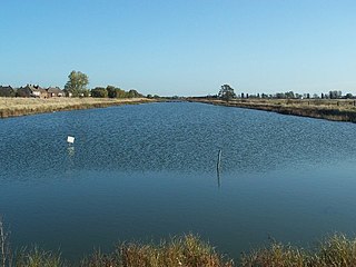
The Swale is a tidal channel of the Thames estuary that separates the Isle of Sheppey from the rest of Kent. On its banks is a 6,509.4-hectare (16,085-acre) biological Site of Special Scientific Interest which stretches from Sittingbourne to Whitstable in Kent. It is also a Ramsar internationally important wetland site and a Special Protection Area under the European Union Directive on the Conservation of Wild Birds. Parts of it are a Nature Conservation Review site, Grade I, National Nature Reserves, a Kent Wildlife Trust nature reserve and a Local Nature Reserve.
The Pennine Cycleway is a Sustrans-sponsored route in the Pennines range in northern England, an area often called the "backbone of England". The route passes through the counties of Derbyshire, West Yorkshire, Lancashire, North Yorkshire, Cumbria and Northumberland. It is part of the National Cycle Network (NCN). Sustrans founder John Grimshaw calls it 'the best National Cycle Network route of the lot'.

The A249 is a road in Kent, England, running from Maidstone to Sheerness on the Isle of Sheppey. It mainly functions as a link between the M2 and M20 motorways, and for goods vehicle traffic to the port at Sheerness.

Leysdown-on-Sea is a village on the east coast of the Isle of Sheppey in the borough of Swale in Kent, England. In 2020 it had an estimated population of 936. The civil parish is Leysdown and includes the settlements of Bay View, Shellness and Harty. In 2011 it had a population of 1,256.

Oare Marshes is a 71.4-hectare (176-acre) Local Nature Reserve north of Faversham in Kent. It is owned and managed by Kent Wildlife Trust. It is part of The Swale Nature Conservation Review site, Grade I, National Nature Reserve, Ramsar internationally important wetland site, Special Protection Area under the European Union Directive on the Conservation of Wild Birds, and Site of Special Scientific Interest.
Elmley is the local name for the Isle of Elmley, part of the Isle of Sheppey in Kent, England. It was also the name of a very late 19th century industrial village on the isle. Edward Hasted describes, in 1798, the isle as two-eighths of the Isle of Sheppey estimated as 11 miles by 8 miles. Its present national nature reserve covers more than the easily traceable area of the former isle by extending to the east, over Windmill Creek, one of two Sheppey inlets, former internal tidal channels.

Oare is a village and civil parish north of Davington, Faversham in southeast England. It is separated from Faversham by the Oare Creek. To the north of the village are the Oare Marshes, and the Harty Ferry which once linked to Harty on the Isle of Sheppey. Kent Wildlife Trust manages a nature reserve that is an important stopping place for migratory birds.
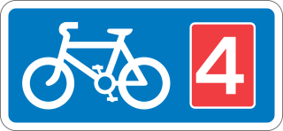
National Cycle Route 4 is a route of the National Cycle Network, running from London to Fishguard, Pembrokeshire. Between these, the route runs through Reading, Bath, Bristol, Newport, Swansea and St David's. Within Wales, sections of the route follow branches of the Celtic Trail cycle route.

National Cycle Route 1 is a route of the National Cycle Network, running from Dover to Tain. The 1,264 mi-long (2,034-kilometre) cycle-path is located in the United Kingdom.
The National Cycle Route 13 is a cycling route that is part of the National Cycle Network in the United Kingdom. It connects Tower Bridge in London with Fakenham in Norwich.
National Cycle Route 78 runs from Campbeltown to Inverness. It was officially launched as the Caledonia Way in 2016 as part of the wider redevelopment of Scotland's cycle network. It runs from the Kintyre peninsula to the Great Glen and the route varies from on road to traffic-free forest trails and canal paths.

National Cycle Route 57 is part of the United Kingdom's National Cycle Network. When complete, it will run west to east from Farmington, Gloucestershire near Northleach to Welwyn Garden City in Hertfordshire.

The Miner's Way Trail is a long-distance circular footpath in England, starting at Sholden, Kent. Linking up the coalfield parishes of East Kent. Including; the parishes of Deal, Ash, Aylesham, Chillenden, Eastry, Eythorne, Elvington, Goodnestone, Nonington, Northbourne, Coldred, Staple, Tilmanstone and Wingham.
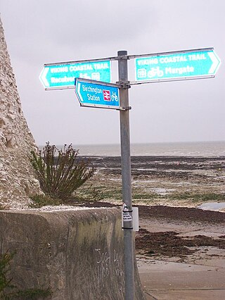
The Viking Coastal Trail is a 25-mile multi-user route around the Isle of Thanet, keeping as close as is possible to the coast. It is also Regional Route 15 of the National Cycle Network. From Reculver, the trail passes through Margate, Broadstairs and Ramsgate to reach Pegwell Bay, where Vikings first landed in Kent. The Trail then, uses an inland route on quiet lanes, passing through a couple of villages with ancient churches including Minster-in-Thanet Abbey and St Nicholas at Wade, to return to Reculver.
Oasis Academy Isle of Sheppey is a coeducational secondary school and sixth form with academy status, located over two sites in Minster-on-Sea on the Isle of Sheppey in the English county of Kent. It is currently managed by the Oasis Community Learning Multi-academy Trust.
The Heron Trail is 15+1⁄2-mile (24.9 km) long cycling trail that links with National Cycle Route 1 between Higham and Strood, then it heads around the Hoo Peninsula via Regional route 18 passing through 'Hoo St Werburgh', 'High Halstow' and 'Cliffe' before returning to Higham. It has a mixture of rural and maritime interest, with views of the River Medway and River Thames.
Barton's Point Coastal Park is on the Isle of Sheppey, in Kent, England. It lies between Minster and Sheerness. Within the park is a former military ditch/canal from Marine Parade heading south-westerly towards West Minster.
References
- ↑ "Thames Estuary Path – Isle of Sheppey Overview" (PDF). www.spokeseastkent.org.uk. 31 October 2008. Retrieved 6 January 2014.
- 1 2 3 4 "Isle of Sheppey cycle routes update". www.spokeseastkent.org.uk. 18 October 2010. Archived from the original on 18 March 2011. Retrieved 6 January 2014.
- ↑ "The Sheerness Way". www.kent.gov.uk. 9 March 2011. Archived from the original on 1 December 2013. Retrieved 6 January 2014.
- ↑ "Update on the exciting new Sheerness Way and Isle of Harty Trail Cycle Routes coming to the Isle of Sheppey". www.spokeseastkent.org.uk. 9 March 2011. Archived from the original on 8 April 2011. Retrieved 6 January 2014.