
Deptford is an area on the south bank of the River Thames in southeast London, within the London Borough of Lewisham. It is named after a ford of the River Ravensbourne. From the mid 16th century to the late 19th it was home to Deptford Dockyard, the first of the Royal Dockyards. This was a major shipbuilding dock and attracted Peter the Great to come and study shipbuilding. Deptford and the docks are associated with the knighting of Sir Francis Drake by Queen Elizabeth I aboard the Golden Hind, the legend of Sir Walter Raleigh laying down his cape for Elizabeth, Captain James Cook's third voyage aboard HMS Resolution, and the mysterious apparent murder of Christopher Marlowe in a house along Deptford Strand.

The Isle of Sheppey is an island off the northern coast of Kent, England, neighbouring the Thames Estuary, centred 42 miles (68 km) from central London. It has an area of 36 square miles (93 km2). The island forms part of the local government district of Swale. Sheppey is derived from Old English Sceapig, meaning "Sheep Island".

Woolwich Dockyard was an English naval dockyard along the river Thames at Woolwich in north-west Kent, where many ships were built from the early 16th century until the late 19th century. William Camden called it 'the Mother Dock of all England'. By virtue of the size and quantity of vessels built there, Woolwich Dockyard is described as having been 'among the most important shipyards of seventeenth-century Europe'. During the Age of Sail, the yard continued to be used for shipbuilding and repair work more or less consistently; in the 1830s a specialist factory within the dockyard oversaw the introduction of steam power for ships of the Royal Navy. At its largest extent it filled a 56-acre site north of Woolwich Church Street, between Warspite Road and New Ferry Approach; 19th-century naval vessels were fast outgrowing the yard, however, and it eventually closed in 1869. The former dockyard area is now partly residential, partly industrial, with remnants of its historic past having been restored.
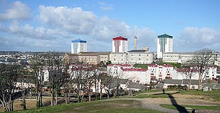
Devonport, formerly named Plymouth Dock or just Dock, is a district of Plymouth in the English county of Devon, although it was, at one time, the more important settlement. It became a county borough in 1889. Devonport was originally one of the "Three Towns" ; these merged in 1914 to form what would become in 1928 the City of Plymouth. It is represented in the Parliament of the United Kingdom as part of the Plymouth Sutton and Devonport constituency. Its elected Member of Parliament (MP) is Luke Pollard, who is a member of the Labour Party. The population of the ward at the 2011 census was 14,788.

Sheerness is a port town and civil parish beside the mouth of the River Medway on the north-west corner of the Isle of Sheppey in north Kent, England. With a population of 11,938, it is the second largest town on the island after the nearby town of Minster which has a population of 21,319.

Pembroke Dock is a town and a community in Pembrokeshire, South West Wales, 3 miles (4.8 km) northwest of Pembroke on the banks of the River Cleddau. Originally Paterchurch, a small fishing village, Pembroke Dock town expanded rapidly following the construction of the Royal Navy Dockyard in 1814. The Cleddau Bridge links Pembroke Dock with Neyland.
Chatham Dockyard was a Royal Navy Dockyard located on the River Medway in Kent. Established in Chatham in the mid-16th century, the dockyard subsequently expanded into neighbouring Gillingham.

Royal Navy Dockyards were state-owned harbour facilities where ships of the Royal Navy were built, based, repaired and refitted. Until the mid-19th century the Royal Dockyards were the largest industrial complexes in Britain.
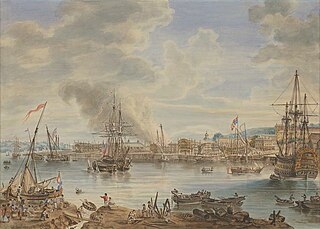
His Majesty's Naval Base, Portsmouth is one of three operating bases in the United Kingdom for the Royal Navy. Portsmouth Naval Base is part of the city of Portsmouth; it is located on the eastern shore of Portsmouth Harbour, north of the Solent and the Isle of Wight. For centuries it was officially known as HM Dockyard, Portsmouth: as a Royal Dockyard, Portsmouth functioned primarily as a state-owned facility for building, repairing and maintaining warships; for a time it was the largest industrial site in the world.
Pembroke Dockyard, originally called Pater Yard, is a former Royal Navy Dockyard in Pembroke Dock, Pembrokeshire, Wales.

St Mary's Island, is part of the Chatham Maritime development area in Medway, South East England. It is located at the northern end of Chatham, adjacent to Brompton and Gillingham. Once part of the Royal Dockyard, Chatham, the area had consisted of a mixture of sports fields and warehousing during the later years of the Royal Navy's time in occupation.
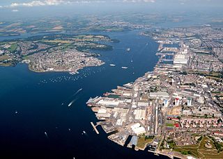
His Majesty's Naval Base, Devonport is one of three operating bases in the United Kingdom for the Royal Navy and is the sole nuclear repair and refuelling facility for the Royal Navy. The largest naval base in Western Europe, HMNB Devonport is located in Devonport, in the west of the city of Plymouth, England.

The East End of London, often referred to within the London area simply as the East End, is the historic core of wider East London, east of the Roman and medieval walls of the City of London and north of the River Thames. It does not have universally accepted boundaries to the north and east, though the River Lea is sometimes seen as the eastern boundary. Parts of it may be regarded as lying within Central London. The term "East of Aldgate Pump" is sometimes used as a synonym for the area.

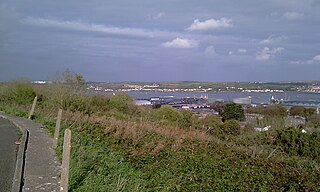
Sheerness Dockyard was a Royal Navy Dockyard located on the Sheerness peninsula, at the mouth of the River Medway in Kent. It was opened in the 1660s and closed in 1960.

Lamplighters Marsh is a public open space and local nature reserve near Shirehampton in the city of Bristol, England. It is a narrow strip of land between the railway line which connects Bristol to Avonmouth, and the River Avon.

Malta Dockyard was an important naval base in the Grand Harbour in Malta in the Mediterranean Sea. The infrastructure which is still in operation is now operated by Palumbo Shipyards.
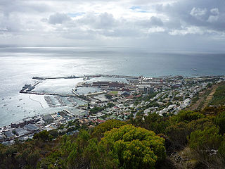
Naval Base Simon's Town is the South African Navy's largest naval base, situated at Simon's Town, near Cape Town. The base provides support functions to Fleet Command.

Sydney Cove West Archaeological Precinct is a heritage-listed precinct that contains The Rocks police station, the Museum of Contemporary Art Australia, car park, parks, shops and roads located at 112–156 George Street, in the inner city Sydney suburb of The Rocks in the City of Sydney local government area of New South Wales, Australia. The precinct previously contained a commissariat store, Maritime Services Board offices, dockyard and Department of Labour & Industry offices. Buildings in the precinct were developed in various stages since 1797 to date, with heritage-listed buildings dating from 1797 to 1939. The precinct is also known as the Museum of Contemporary Art, Maritime Services Board, Colonial Government naval dockyard, Commissariat Stores, Colonial Hospital, Kings and Queens Wharf and First Fleet Park. The property is owned by Property NSW, an agency of the Government of New South Wales. It was added to the New South Wales State Heritage Register on 5 August 2011.


