Bartholomew de Badlesmere, 1st Baron Badlesmere was an English soldier, diplomat, member of parliament, landowner and nobleman. He was the son and heir of Sir Gunselm de Badlesmere and Joan FitzBernard. He fought in the English army both in France and Scotland during the later years of the reign of Edward I of England and the earlier part of the reign of Edward II of England. He was executed after participating in an unsuccessful rebellion led by Thomas, 2nd Earl of Lancaster.

Barfrestone is a village and a former civil parish, now in the parish of Eythorne, in the Dover district, in east Kent, England. It is between Shepherdswell, Eythorne and Nonington, close to the former pit villages of Elvington and Snowdown. In 1931 the parish had a population of 91. On 1 April 1935 the parish was abolished and merged with Eythorne.
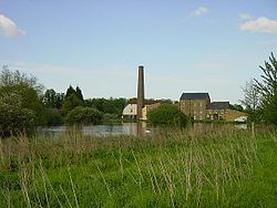
Luddenham is a widespread hamlet or small village north-west of Faversham in Kent, England, with many long-distance views across the Swale and the Isle of Sheppey. It is on the edge of Luddenham Marshes and is also home of Luddenham School. Oare Gunpowder Works are on the edge of the village. It had, according to Edward Hasted in 1798, 396 acres of low flat arable land and 200 acres of meadow and pasture, although half of those are marsh. It is in the civil parish of Norton, Buckland and Stone.

Badlesmere is a village and civil parish in the Swale district of Kent, England, about five miles south of Faversham and eight miles north of Ashford on the A251.

Bapchild is a village and civil parish in the Swale district of Kent, England, about two miles inside of Sittingbourne. It lies on the old Roman road now the A2, and according to the 2001 census, the parish had a population of 1,068, including Tonge, increasing to 1,141 at the 2011 Census.

Bobbing is a village and civil parish in the Swale district of Kent, England, about a mile north-west of Sittingbourne, and forming part of its urban area. The hamlet of Howt Green and village of Keycol are included within the parish. According to the 2011 census Bobbing parish had a population of 1,969.

Ospringe is a village and area of Faversham in the English county of Kent. It is also the name of a civil parish, which since 1935 has not included the village of Ospringe.

Milton Regis is a village in the district of Swale in Kent, England. Former names include Milton-next-Sittingbourne, Milton Royal, Middleton, Midletun and Middletune. It has a population of about 5,000. Today it is a suburb of Sittingbourne, although this has not always been the case. Until around 1800, Sittingbourne was a small hamlet and under the control of the Manor of Milton Regis.
Milstead is a village and civil parish in the borough of Swale in Kent, England. It is surrounded by the villages of Frinsted, Wichling, Doddington and Lynsted in Kent, England. It is the southernmost parish in the Sittingbourne area, and is approximately 3 miles (4.8 km) from Sittingbourne town centre, just south of the M2 motorway.
Murston is a suburb of Sittingbourne, in the Swale district, in the county of Kent, England. It is about 1 mile north-east of central Sittingbourne, on the east bank of the Milton Creek.

Tunstall is a linear village and civil parish in Swale in Kent, England. It is about 2 km to the southwest of the centre of Sittingbourne, on a road towards Bredgar.

Oare is a village and civil parish north of Davington, Faversham in southeast England. It is separated from Faversham by the Oare Creek. To the north of the village are the Oare Marshes, and the Harty Ferry which once linked to Harty on the Isle of Sheppey. Kent Wildlife Trust manages a nature reserve that is an important stopping place for migratory birds.

Frinsted or Frinstead is a small village and civil parish in the ecclesiastical parish of Wormshill and in the Maidstone District of Kent, England. and has been a recorded settlement as far back as the Domesday Book and indeed was the only settlement in the surrounding area to be described at the time to have a church. The village exists in the Hundred of Eyhorne.

Highsted is a village near Sittingbourne in Kent, England. It is in the civil parish of Rodmersham.

Coldred is a settlement and former civil parish, now in the parish of Shepherdswell with Coldred, in the Dover district of Kent, England. The main part of the village is Coldred Street which lies 1⁄2 mile (0.80 km) to the south-west. In 1961 the parish had a population of 153.

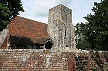
St Giles Church is the sole church in the village of Wormshill in Kent. The church is Anglican and is dedicated to Saint Giles. It forms part of the united benefice of Tunstall with Bredgar. The other parishes are Milstead, Bicknor and Frinsted and Rodmersham. The ecclesiastical parish of Wormshill is in the Diocese of Canterbury and the Sittingbourne deanery. It is a Grade II listed building, English Heritage number 1060971.
Sir Thomas Browne was a Member of Parliament and Chancellor of the Exchequer. Browne's tenure as Chancellor occurred during the Great Bullion Famine and the Great Slump in England. He was executed for treason on 20 July 1460.
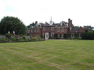
Sharsted Court is a grade I listed manor house set in woodland near the village of Newnham, Kent England. A house or lodge has been recorded at the site since the time of Odo de Bayeux in 1080, however the present building, exhibiting a number of later styles, principally dates from the 18th century. Earlier residents of the site may have included Iron Age settlers since excavations of earthworks on the estate in 1825 and 1880 revealed evidence of possible Belgic fortifications.

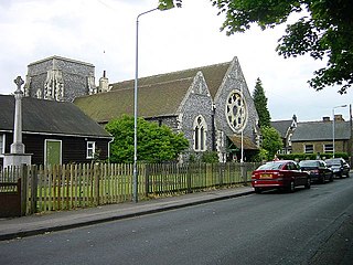
Rodmersham is a village and civil parish in the Borough of Swale in the north of the English county of Kent. It is just under 1 mile (1.6 km) south of Bapchild on the A2 road and 1.5 miles (2.4 km) south-east of the town of Sittingbourne. Rodmersham Green, which forms the bulk of the modern village, is 0.5 miles (0.80 km) to the south-west of the village church towards the Highsted Valley and Tunstall.

Norton, Buckland and Stone is a small rural civil parish 1 mile (1.6 km) east of Teynham and 3 miles (4.8 km) west of the centre of Faversham in the borough of Swale, Kent, England. It is bypassed by the M2 to the south and traverses the historic A2, on the route of the Roman road of Watling Street. In 2011 the parish had a population of 467.