Dover Castle

Last updated

Dover Castle
Dover, Kent, England
1 dover castle aerial panorama 2017.jpg
Aerial panorama of the castle
Kent UK location map.svg
Red pog.svg
Dover Castle
Coordinates 51°07′47″N1°19′17″E / 51.1297°N 1.3214°E / 51.1297; 1.3214
Type Norman castle
Site information
Owner English Heritage
ConditionIntact
Site history
Built12th century
Built by Henry II
Events First Barons' War

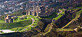
Dover Castle is a medieval castle in Dover, Kent, England and is Grade I listed. It was founded in the 11th century and has been described as the "Key to England" due to its defensive significance throughout history. [1] [2] Some writers say it is the largest castle in England, [3] a title also claimed by Windsor Castle. [4]

Contents

History

Iron age

This site may have been fortified with earthworks in the Iron Age or earlier, before the Romans invaded in AD 43. This is suggested on the basis of the unusual pattern of the earthworks which does not seem to be a perfect fit for the medieval castle. Excavations have provided evidence of Iron Age occupation within the locality of the castle, but it is not certain whether this is associated with the hillfort. [5]

Roman era

The Roman lighthouse, later converted into a bell tower for the adjacent church DoverCastle-lighthouse-2004-10-03.jpg
The Roman lighthouse, later converted into a bell tower for the adjacent church

The site also contains one of Dover's two Roman lighthouses (or pharoses), one of only three surviving Roman-era lighthouses in the world, and the tallest and most complete standing Roman structure in England. [6] It is also claimed to be Britain's oldest standing building. [7] Built in the early 2nd century, the 5-level 8-sided tower was made of layers of tufa, Kentish ragstone, and red bricks. [6] The castle lighthouse survived after being converted into a belfry in the Saxon era (c.1000), having a new upper layer added (c.1430), and was partially renovated in 1913–1915. The scant remains of the other Roman lighthouse, known as the Bredenstone or the Devil's Drop of Mortar, are located on the opposing Western Heights, across the town of Dover. [8]

The Tour d'Ordre in 1550 La Tour d'Odre en 1550, Boulogne-sur-Mer..jpg
The Tour d'Ordre in 1550

The Roman lighthouse at Boulogne-sur-Mer across the Channel, known as the Tour d'Ordre, survived for many centuries, and its light should have been visible from Dover. It was built circa AD 39 by order of the Emperor Caligula, possibly in preparation for an invasion of Britain. Suetonius refers to Caligula's "erection of a tall lighthouse, not unlike the one at Pharos, in which fires were to be kept going all night as a guide to ships". [9] Coastal erosion led to it toppling into the sea in 1644. Engravings of its height may show how the Dover Roman lighthouse once looked. [10]

Saxon and early Norman

The view down from the (possibly Saxon) burgh, and Harbour beyond. Castle Church and Harbour.JPG
The view down from the (possibly Saxon) burgh, and Harbour beyond.

After the Battle of Hastings in October 1066, William the Conqueror and his forces marched to Westminster Abbey for his coronation. They took a roundabout route via Romney, Dover and Canterbury. From the Cinque Ports foundation in 1050, Dover has always been a chief member—it may also have been this that first attracted William's attention, and got Kent the motto of Invicta. In the words of William of Poitiers:

Then he marched to Dover, which had been reported impregnable and held by a large force. The English, stricken with fear at his approach had confidence neither in their ramparts nor in the numbers of their troops ... While the inhabitants were preparing to surrender unconditionally, [the Normans], greedy for money, set the castle on fire and the great part of it was soon enveloped in flames...[William then paid for the repair and] having taken possession of the castle, the Duke spent eight days adding new fortifications to it'. The Castle was first built, entirely out of clay. It collapsed to the ground and the clay was then used as the flooring for many of the ground-floor rooms. [11]

In 1088, eight knights were appointed under tenures to guard Dover Castle. Their names were William d'Albrincis, Fulberl (or Fulbert) de Dover, William d'Arsic, Geoffrey Peverell, William Maminot, Robert du Port, Hugh Crevecoeur, and Adam Fitzwilliam. [12]

Henry II to early modern times

Henry II's Great Tower (the keep) Dover Castle - Henry II's Great Tower.jpg
Henry II's Great Tower (the keep)
The castle from the north Dover Castle from the north.jpg
The castle from the north
The castle from south-east Dover Castle SE.jpg
The castle from south-east

It was during the reign of Henry II that the castle began to take recognisable shape. The inner and outer baileys and the great keep belong to this time. Maurice the Engineer was responsible for building the keep. [13] From 1179 to 1188, the king spent over £6,500 on the castle, an enormous sum considering that his annual revenue was likely around £10,000. [14]

In 1216, during the First Barons' War, a group of rebel barons invited the future Louis VIII of France to come and take the English crown. He had some success breaching the walls, but was ultimately unable to take the castle. [15] The vulnerable north gate that had been breached in the siege was converted into an underground forward-defence complex (including St John's Tower), and new gates built into the outer curtain wall on the western (Fitzwilliam's Gate) and eastern (Constable's Gate) sides. During the siege, the English defenders tunnelled outwards and attacked the French. [15]

During the time of Stephen de Pencester, a windmill was erected on Tower 22, which was later known as the Mill Tower. [16] By the Tudor age, the defences themselves had been superseded by gunpowder. They were improved by Henry VIII, who made a personal visit and added to it with the Moat Bulwark. [17]

During the English Civil War, it was held for the king but then taken by supporters of the Parliamentarians in 1642 without a shot being fired. [18] Knowing the castle was lightly guarded, a local merchant Richard Dawkes accompanied by 10 men scaled the cliffs and attacked the porter's lodge, obtaining the keys and entering the castle before the garrison was summoned. [19] [20]

Dover Castle was a crucial observation point for the cross-channel sightings of the Anglo-French Survey, which used trigonometric calculations to link the Royal Greenwich Observatory with the Paris Observatory. This work was overseen by General William Roy. [21]

19th century

Dover Castle in 2011 Dover Castle aerial view.jpg
Dover Castle in 2011

Massive rebuilding took place at the end of the 18th century during the Napoleonic Wars. William Twiss, the Commanding Engineer of the Southern District, as part of his brief to improve the town's defences, completed the remodelling of the outer defences of Dover Castle by adding the huge Horseshoe, Hudson's, East Arrow and East Demi-Bastions to provide extra gun positions on the eastern side, and constructing the Constable's Bastion for additional protection on the west. Twiss further strengthened the Spur at the northern end of the castle, adding a redan, or raised the gun platform. By taking the roof off the keep and replacing it with massive brick vaults, he was able to mount heavy artillery on the top. Twiss also constructed Canon's Gateway to link the defences of the castle with those of the town. [22]

With Dover becoming a garrison town, there was a need for barracks and storerooms for the additional troops and their equipment. The solution adopted by Twiss and the Royal Engineers was to create a complex of barracks tunnels about 15 metres below the cliff-top, and the first troops were accommodated in 1803. [22] The windmill on the Mill Tower was demolished during the Anglo-American War on the orders of the Ordnance Board. It was said that the sale of materials from the demolished mill did not cover the cost of the demolition. [16] At the end of the Napoleonic Wars, the tunnels were partly converted and used by the Coast Blockade Service to combat smuggling. This was a short-term endeavour, though, and in 1827 the headquarters were moved closer to shore. The tunnels then remained abandoned for more than a century. [23]

Between 1856 and 1858, Anthony Salvin constructed a new officer's barracks to the south of the castle. Salvin was responsible for the exterior, which he designed in a Tudor Revival style, while the castle's Clerk of the Works, G. Arnold, was responsible for the interior. [24]

Second World War

The Second World War Coastal Artillery Operations Room in the Secret Wartime Tunnels Coastal artillery operations.jpg
The Second World War Coastal Artillery Operations Room in the Secret Wartime Tunnels

The outbreak of the Second World War in 1939 saw the tunnels converted first into an air-raid shelter and then later into a military command centre and underground hospital. In May 1940, Admiral Sir Bertram Ramsay directed the evacuation of French and British soldiers from Dunkirk, code-named Operation Dynamo, from his headquarters in the cliff tunnels. [23] A military telephone exchange was installed in 1941 and served the underground headquarters. The switchboards were constantly in use and had to have a new tunnel created alongside it to house the batteries and chargers necessary to keep them functioning. [23] A statue of Admiral Sir Bertram Ramsay stands outside the tunnels in honour of his work on the Dunkirk evacuation and protecting Dover during the Second World War. [25]

Post-war

After the war the tunnels were to be used as a shelter for the Regional Seats of Government in the event of a nuclear attack. [23] This plan was abandoned for various reasons, including the realisation that the chalk of the cliffs would not provide significant protection from radiation, and because of the inconvenient form of the tunnels and their generally poor condition. [23] Tunnel levels are denoted as A - Annexe, B - Bastion, C - Casemate, D - Dumpy and E - Esplanade. Annexe and Casemate levels are open to the public, Bastion is 'lost', but investigations continue to locate it and gain access. Dumpy (converted from Second World War use, to serve as a Regional Seat of Government in the event of an atomic war) is closed, together with its esplanade (last used as an air raid shelter in the Second World War). [26]

The renovated guest hall Dover Castle Great Tower The guest hall.JPG
The renovated guest hall

Between 2007 and 2009, English Heritage spent £2.45 million on recreating the castle's interior. [27] According to figures released by the Association of Leading Visitor Attractions, 368,243 people visited Dover Castle in 2019. [28] The Queen's & Princess of Wales's Royal Regiment Regimental Museum is located in the castle. [29]

Dover Castle remains a Scheduled Monument, [30] which means it is a "nationally important" historic building and archaeological site that has been given protection against unauthorised change. [31] It is also a Grade I listed building, [32] and recognised as an internationally important structure. [33] The Lord Warden of the Cinque Ports is officially head of the castle, in his conjoint position of Constable of Dover Castle, and the Deputy Constable has his residence in Constable's Gate. [34]

In October 2021, the castle was one of 142 sites across England to receive part of a £35 million grant from the government's Culture Recovery Fund. [35]

Churches and chapels

The church of St Mary in Castro, built next to the Roman lighthouse (left) St Mary in Castro, Dover.jpg
The church of St Mary in Castro, built next to the Roman lighthouse (left)

There are two sacred places within the grounds of the castle:

Filming location

Dover Castle DoverCastle.jpg
Dover Castle

The castle has been used by productions in TV series such as the Doctor Who episode The Mind of Evil , [38] Wolf Hall , [39] The Hollow Crown [40] and The Amazing Race 31 . [41] The medieval setting has also been used in theatrical releases such as Lady Jane (1986), Hamlet (1990), To Kill a King (2003), The Other Boleyn Girl (2007), Into the Woods (2014), and Avengers: Age of Ultron (2015). [42]

See also

Notes

  1. Kerr, Nigel (1984). A Guide to Norman Sites in Britain. Granada. p. 44. ISBN   0-586-08445-2.
  2. Broughton, Bradford B. (1988). Dictionary of Medieval Knighthood and Chivalry. Greenwood Press. p. 102. ISBN   0-313-25347-1.
  3. Cathcart King, David J. (1983). Catellarium Anglicanum: An Index and Bibliography of the Castles in England, Wales and the Islands. Volume I: Anglesey–Montgomery. Kraus International Publications. p. 230.
  4. "10 Largest Castles in the World" . Retrieved 2019-03-03.
  5. National Monuments Record. "MONUMENT NO. 468006". English Heritage. Archived from the original on 27 February 2014. Retrieved 2012-04-23.
  6. 1 2 "The Roman Pharos at Dover Castle". Google Arts & Culture. Retrieved 8 April 2019.
  7. "Roman Lighthouse, Dover". Lonely Planet. Retrieved 2 March 2020.
  8. "The Roman Lighthouse, Dover, Kent". The Journal of Antiquities. 12 May 2013. Retrieved 5 June 2018.
  9. Suetonius, The Twelve Caesars , Gaius (Caligula), chapter 46.
  10. "Boulogne Tour d'Ordre Light". Lighthouse Explorer. Retrieved 20 January 2021.
  11. William of Poitiers, Gesta Guillelmi, ed. and tr. R. H. C. Davis and Marjorie Chibnall (1998). The Gesta Guillelmi of William of Poitiers. OMT. Oxford and New York: Clarendon. ISBN   0-19-820553-8.
  12. Hasted, Edward (1799). "The History and Topographical Survey of the County of Kent". Simmons and Kirkby. p. 61.
  13. Prestwich, Michael (1999). Armies and Warfare in the Middle Ages. Yale University Press. p. 285. ISBN   0-300-07663-0.
  14. Dr, Jeffrey L. Forgeng; Forgeng, Jeffrey L.; Singman, Jeffrey L. (1999). Daily Life in Medieval Europe. Greenwood Publishing Group. p. 109. ISBN   9780313302732.
  15. 1 2 "Dover Castle and the Great Siege of 1216". De Re Militari. 28 April 2014. Retrieved 5 June 2018.
  16. 1 2 Coles Finch, William (1933). Watermills and Windmills. London: C W Daniel Company. p. 196.
  17. "Dover Castle - Moat's Bulwark". Dover – Kent. Retrieved 5 June 2018.
  18. "Civil War in the South-East 1642". British Cilil War Project. Retrieved 5 June 2018.
  19. The land we live in, a pictorial and literary sketch-book of the British empire. London: Charles Knight. 1849. p. 128.
  20. "Richard Dawkes and John Reading – the Civil Wars and Interregnum". The Dover Historian. 18 December 2013. Retrieved 18 April 2019.
  21. Roy, William (1785). "An Account of the Measurement of a Base on Hounslow-Heath". Philosophical Transactions of the Royal Society of London. 75: 385–480. doi: 10.1098/rstl.1785.0024 .
  22. 1 2 "Dover Castle". Kent Past. Retrieved 5 June 2018.
  23. 1 2 3 4 5 "Dover Castle: Secret Wartime Tunnels". Beyond the Point. Retrieved 5 June 2018.
  24. Historic England. "Officers' Barracks, Queen Elizabeth Road (Grade II) (1375601)". National Heritage List for England . Retrieved 8 May 2021.
  25. Admiral Sir Bertram Ramsay Archived 25 March 2015 at the Wayback Machine at www.dover-kent.co.uk
  26. "Dover Castle". www.dovertowncouncil.co.uk. Archived from the original on 2 April 2013. Retrieved 25 July 2012.
  27. "King's lavish castle is brought to life", BBC News, 31 July 2009, retrieved 7 March 2011
  28. "ALVA - Association of Leading Visitor Attractions". www.alva.org.uk. Retrieved 28 October 2020.
  29. "Queen's & PWRR Regiment Museum". 1st Battalion the Queen’s Regiment. Retrieved 5 June 2018.
  30. "Dover Castle", Pastscape, English Heritage, archived from the original on 7 October 2012, retrieved 2011-03-07
  31. "Scheduled Monuments". Historic England. Retrieved 29 March 2017.
  32. "Dover Castle". British Listed Buildings. Retrieved 29 March 2017.
  33. "Frequently asked questions", Images of England , English Heritage, archived from the original on 20 February 2010, retrieved 2011-03-07
  34. "List of Lord Wardens". Cinque Ports. Retrieved 5 June 2018.
  35. "Heritage and Craft Workers Across England Given a Helping Hand"Historic England, 22 October 2021
  36. "History of Dover Castle". English Heritage. Retrieved 8 April 2019.
  37. Historic England. "Church of St Mary Sub-Castro (Grade I) (1070328)". National Heritage List for England . Retrieved 17 September 2016.
  38. Kent Film Office. "Kent Film Office The Mind of Evil Article".
  39. Kent Film Office (9 January 2015). "Kent Film Office Wolf Hall Article" . Retrieved 7 October 2019.
  40. Kent Film Office. "Kent Film Office The Hollow Crown: The Wars of the Roses Article".
  41. Walker, Jodi (27 June 2019). "The Amazing Race finale recap: The sacred feminine for the win". Entertainment Weekly . Retrieved 10 December 2020.
  42. "Dover Castle". Kent Film Office. 11 May 2021.

Further reading

Images

Related Research Articles

<span class="mw-page-title-main">Dover</span> Town and major ferry port in England

Dover is a town and major ferry port in Kent, South East England. It faces France across the Strait of Dover, the narrowest part of the English Channel at 33 kilometres (21 mi) from Cap Gris Nez in France. It lies south-east of Canterbury and east of Maidstone. The town is the administrative centre of the Dover District and home of the Port of Dover.

<span class="mw-page-title-main">Edinburgh Castle</span> Historic castle in Edinburgh, Scotland

Edinburgh Castle is a historic castle in Edinburgh, Scotland. It stands on Castle Rock, which has been occupied by humans since at least the Iron Age. There has been a royal castle on the rock since at least the reign of Malcolm III in the 11th century, and the castle continued to be a royal residence until 1633. From the 15th century, the castle's residential role declined, and by the 17th century it was principally used as a military garrison. Its importance as a part of Scotland's national heritage was recognised increasingly from the early 19th century onwards, and various restoration programmes have been carried out over the past century and a half.

<span class="mw-page-title-main">Walmer Castle</span> Castle in Kent

Walmer Castle is an artillery fort originally constructed by Henry VIII in Walmer, Kent, between 1539 and 1540. It formed part of the King's Device programme to protect against invasion from France and the Holy Roman Empire, and defended the strategically important Downs anchorage off the English coast. Comprising a keep and four circular bastions, the moated stone castle covered 0.61 acres (0.25 ha) and had 39 firing positions on the upper levels for artillery. It cost the Crown a total of £27,092 to build the three castles of Walmer, Sandown, and Deal, which lay adjacent to one another along the coast and were connected by earthwork defences. The original invasion threat passed, but during the Second English Civil War of 1648–49, Walmer was seized by pro-Royalist insurgents and was only retaken by Parliamentary forces after several months' fighting.

<span class="mw-page-title-main">Walmer</span> Human settlement in England

Walmer is a town in the district of Dover, Kent, in England. Located on the coast, the parish of Walmer is six miles (9.7 km) south-east of Sandwich, Kent. The town's coastline and castle are popular amongst tourists. It has a population of 6,693 (2001), increasing to 8,178 at the 2011 Census.

<span class="mw-page-title-main">White Cliffs of Dover</span> English cliff shore

The White Cliffs of Dover are the region of English coastline facing the Strait of Dover and France. The cliff face, which reaches a height of 350 feet (110 m), owes its striking appearance to its composition of chalk accented by streaks of black flint, deposited during the Late Cretaceous. The cliffs, on both sides of the town of Dover in Kent, stretch for eight miles (13 km). The White Cliffs of Dover form part of the North Downs. A section of coastline encompassing the cliffs was purchased by the National Trust in 2016.

<span class="mw-page-title-main">Deal Castle</span> 16th century artillery fort in Kent, England

Deal Castle is an artillery fort constructed by Henry VIII in Deal, Kent, between 1539 and 1540. It formed part of the King's Device programme to protect against invasion from France and the Holy Roman Empire, and defended the strategically important Downs anchorage off the English coast. Comprising a keep with six inner and outer bastions, the moated stone castle covered 0.85 acres (0.34 ha) and had sixty-six firing positions for artillery. It cost the Crown a total of £27,092 to build the three castles of Deal, Sandown and Walmer, which lay adjacent to one another along the coast and were connected by earthwork defences. The original invasion threat passed but, during the Second English Civil War of 1648–49, Deal was seized by pro-Royalist insurgents and was only retaken by Parliamentary forces after several months' fighting.

<span class="mw-page-title-main">First Barons' War</span> Civil war in the Kingdom of England

The First Barons' War (1215–1217) was a civil war in the Kingdom of England in which a group of rebellious major landowners led by Robert Fitzwalter waged war against King John of England. The conflict resulted from King John's disastrous wars against King Philip II of France, which led to the collapse of the Angevin Empire, and John's subsequent refusal to accept and abide by the Magna Carta, which John had sealed on 15 June 1215.

<span class="mw-page-title-main">Device Forts</span> Artillery fortifications built to defend the southern coast of England by Henry VIII

The Device Forts, also known as Henrician castles and blockhouses, were a series of artillery fortifications built to defend the coast of England and Wales by Henry VIII. Traditionally, the Crown had left coastal defences in the hands of local lords and communities but the threat of French and Spanish invasion led the King to issue an order, called a "device", for a major programme of work between 1539 and 1547. The fortifications ranged from large stone castles positioned to protect the Downs anchorage in Kent, to small blockhouses overlooking the entrance to Milford Haven in Pembrokeshire, and earthwork bulwarks along the Essex coast. Some forts operated independently, others were designed to be mutually reinforcing. The Device programme was hugely expensive, costing a total of £376,000 ; much of this was raised from the proceeds of the Dissolution of the Monasteries a few years before.

<span class="mw-page-title-main">Hurst Castle</span> Device Fort in Hampshire, England

Hurst Castle is an artillery fort established by Henry VIII on the Hurst Spit in Hampshire, England, between 1541 and 1544. It formed part of the king's Device Forts coastal protection programme against invasion from France and the Holy Roman Empire, and defended the western entrance to the Solent waterway. The early castle had a central keep and three bastions, and in 1547 was equipped with 26 guns. It was expensive to operate due to its size, but it formed one of the most powerful forts along the coast. During the English Civil War of the 1640s, Hurst was held by Parliament and was used briefly to detain King Charles I before his execution in 1649. It continued in use during the 18th century but fell into disrepair, the spit being frequented by smugglers.

<span class="mw-page-title-main">Dover Western Heights</span>

The Western Heights of Dover are one of the most impressive fortifications in Britain. They comprise a series of forts, strong points and ditches, designed to protect the country from invasion. They were created in the 18th and 19th centuries to augment the existing defences and protect the key port of Dover from both seaward and landward attack; by the start of the 20th century Dover Western Heights was collectively reputed to be the 'strongest and most elaborate' fortification in the country. The Army finally withdrew from the Heights in 1956–61; they are now a local nature reserve.

<span class="mw-page-title-main">Fort Amherst</span> Fortification in South East England

Fort Amherst, in Medway, South East England, was constructed in 1756 at the southern end of the Brompton lines of defence to protect the southeastern approaches to Chatham Dockyard and the River Medway against a French invasion. Fort Amherst is now open as a visitor attraction throughout the year with tours provided through the tunnel complex

<span class="mw-page-title-main">Pendennis Castle</span> Device Fort in Falmouth, England

Pendennis Castle is an artillery fort constructed by Henry VIII near Falmouth, Cornwall, England between 1540 and 1542. It formed part of the King's Device programme to protect against invasion from France and the Holy Roman Empire, and defended the Carrick Roads waterway at the mouth of the River Fal. The original, circular keep and gun platform was expanded at the end of the century to cope with the increasing Spanish threat, with a ring of extensive stone ramparts and bastions built around the older castle. Pendennis saw service during the English Civil War, when it was held by the Royalists, and was only taken by Parliament after a long siege in 1646. It survived the interregnum and Charles II renovated the fortress after his restoration to the throne in 1660.

<span class="mw-page-title-main">Dubris</span>

Dubris, also known as Portus Dubris and Dubrae, was a port in Roman Britain on the site of present-day Dover, Kent, England.

<span class="mw-page-title-main">Queenborough Castle</span>

Queenborough Castle, also known as Sheppey Castle, is a 14th-century castle, the remnants of which are in the town of Queenborough on the Isle of Sheppey, Kent in England. The castle and the associated planned town were built on the orders of King Edward III from 1361 and named in honour his wife, Queen Philippa. It was the first concentric castle to be built in England, and the only royal castle to be new-built in England during the Late Middle Ages. Overlooking the Swale, then an important waterway approaching the River Medway, Queenborough Castle formed part of the country's coastal defences until 1650 when it was declared to be unfit for use and was almost completely demolished shortly afterwards. The site is now a public park and the only visible remains are some low earthworks.

<span class="mw-page-title-main">William Twiss</span> British Army Royal Engineer

General William Twiss,, was a British Army Royal Engineer, responsible for the design of many military defences.

The History of Dover, because of the town's proximity to the Continent begins when Stone Age people crossed what was then a land bridge, before the opening up of the English Channel. Since then, successive invasions of peoples have taken place. Archaeological finds have revealed a great deal, particularly about cross channel trade and the attempts of those various inhabitants to build large-scale defences against European invaders on this part of the English coast.

<span class="mw-page-title-main">Worcester city walls</span> Defensive structures in Worcester, UK

Worcester's city walls are a sequence of defensive structures built around the city of Worcester in England between the 1st and 17th centuries. The first walls to be built around Worcester were constructed by the Romans. These early walls lasted beyond the fall of the Empire, and the defences encouraged several early Christian foundations to establish themselves in Worcester during the troubled 6th and 7th centuries. The Anglo-Saxons expanded Worcester in the 890s, forming a new walled, planned city, called a burh. The burh utilised the southern stretches of the old Roman walls, but pushed further north to enclose a much larger area. The Anglo-Saxon city walls were maintained by a share of taxes on a local market and streets, in an agreement reinforced by a royal charter.

<span class="mw-page-title-main">Fortifications of Gibraltar</span> Defensive military constructions at the Rock of Gibraltar

The Gibraltar peninsula, located at the far southern end of Iberia, has great strategic importance as a result of its position by the Strait of Gibraltar where the Mediterranean Sea meets the Atlantic Ocean. It has repeatedly been contested between European and North African powers and has endured fourteen sieges since it was first settled in the 11th century. The peninsula's occupants – Moors, Spanish, and British – have built successive layers of fortifications and defences including walls, bastions, casemates, gun batteries, magazines, tunnels and galleries. At their peak in 1865, the fortifications housed around 681 guns mounted in 110 batteries and positions, guarding all land and sea approaches to Gibraltar. The fortifications continued to be in military use until as late as the 1970s and by the time tunnelling ceased in the late 1960s, over 34 miles (55 km) of galleries had been dug in an area of only 2.6 square miles (6.7 km2).

Admiral of the Fleet Sir Ralph de Spigurnell or Ralph Spigurnell, was a Medieval knight, diplomatic envoy and English naval commander who was appointed Admiral of all the Fleets of the English Navy, Warden of the Cinque Ports and Constable of Dover Castle who served under King Edward III of England from 1337 to 1373.