Maiden Castle is an Iron Age hillfort 1.6 mi (2.6 km) southwest of Dorchester, in the English county of Dorset. Hill forts were fortified hill-top settlements constructed across Britain during the Iron Age.

Manduessedum or Manduesedum was a Roman fort and later a civilian small town in the Roman Province of Britannia. It was located on and immediately to the east of the site of the modern village of Mancetter, located in the English county of Warwickshire, close to the modern town of Atherstone. The name is of Romano-Celtic origin, and is likely derived from the Gaulish essedum, meaning 'chariot', whilst the first element mandu was common in Gaulish place names, but its meaning is obscure.

Trimontium was a Roman fort complex located at Newstead, near Melrose, in the Scottish Borders, in view of the three Eildon Hills which probably gave its name.

Ambresbury Banks is the name given to the remains of an Iron Age hill fort in Epping Forest, Essex, England.

Danebury is an Iron Age hillfort in Hampshire, England, about 19 kilometres (12 mi) north-west of Winchester. The site, covering 5 hectares, was excavated by Barry Cunliffe in the 1970s. Danebury is considered a type site for hillforts, and was important in developing the understanding of hillforts, as very few others have been so intensively excavated.

Badbury Rings is an Iron Age hill fort and Scheduled Monument in east Dorset, England. It was in the territory of the Durotriges. In the Roman era a temple was located immediately west of the fort, and there was a Romano-British town known as Vindocladia a short distance to the south-west.

This is about the history of the County of Warwick situated in the English Midlands. Historically, bounded to the north-west by Staffordshire, by Leicestershire to the north-east, Northamptonshire to the east, Worcestershire to the west, Oxfordshire to the south, Gloucestershire to the south-west, an exclave of Derbyshire to the far north, and less than 400 yards from the border with Shropshire in the far west.

High Cross is the name given to the crossroads of the Roman roads of Watling Street and Fosse Way on the border between Leicestershire and Warwickshire, England. A naturally strategic high point, High Cross was "the central cross roads" of Anglo-Saxon and Roman Britain. It was the site of a Romano-British settlement known as Venonae or Venonis, with an accompanying fort.

Birdoswald Roman Fort was known as Banna in Roman times, reflecting the geography of the site on a triangular spur of land bounded by cliffs to the south and east commanding a broad meander of the River Irthing in Cumbria below.

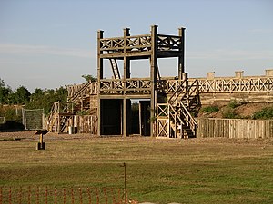
Baginton is a village and civil parish in the Warwick district of Warwickshire, England, and has a common border with the City of Coventry / West Midlands county. With a population of 801, Baginton village is 4 miles (6.4 km) south of central Coventry, 4.5 miles (7.2 km) northeast of Kenilworth and 7 miles (11 km) north of Leamington Spa. The population had reduced slightly to 755 at the 2011 Census. The Lucy Price playing field is situated centrally in the village.

Cilurnum or Cilurvum was an ancient Roman fort on Hadrian's Wall at Chesters near the village of Walwick, Northumberland. It is also known as Walwick Chesters to distinguish it from Great Chesters fort and Halton Chesters.

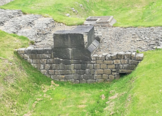
Coria was a fort and town 2.5 miles (4.0 km) south of Hadrian's Wall, in the Roman province of Britannia. It was strategically located on the junction of a major Roman north–south road with the River Tyne and the Roman Stanegate road, which was also the first frontier line which ran east–west between Coria and Luguvalium. Corbridge Roman Site is in the village of Corbridge in the county of Northumberland.

Castleshaw Roman fort was a castellum in the Roman province of Britannia. Although there is no evidence to substantiate the claim, it has been suggested that Castleshaw Roman fort is the site of Rigodunum, a Brigantian settlement. The remains of the fort are located on Castle Hill on the eastern side of Castleshaw Valley at the foot of Standedge but overlooking the valley. The hill is on the edge of Castleshaw in Greater Manchester. The fort was constructed in c. AD 79, but fell out of use at some time during the 90s. It was replaced by a smaller fortlet, built in c. 105, around which a civilian settlement grew. It may have served as a logistical and administrative centre, although it was abandoned in the 120s.
Condercum was a Roman fort on the site of the modern-day Condercum Estate in Benwell, a suburb of Newcastle upon Tyne, England. It was the third fort on Hadrian's Wall, about 6.8 miles east of Rudchester fort and only 2.4 miles west of Pons Aelius fort (Newcastle), and was situated on a hilltop 2 miles (3 km) to the west of the city.

Uxelodunum was a Roman fort with associated civilian settlement (vicus) in modern-day Carlisle, Cumbria, England. It was the largest fort on Hadrian's Wall and is now buried beneath the suburb of Stanwix.

Burrough Hill is an Iron Age hillfort in Burrough on the Hill, 7 miles (11 km) south of Melton Mowbray in the English county of Leicestershire. Situated on a promontory about 210 metres (690 ft) above sea level, the site commands views over the surrounding countryside for miles around. There has been human activity in the area since at least the Mesolithic, and the hillfort was founded in the early Iron Age. In the medieval period, after the hillfort was abandoned, the hill was used as farmland. This ended in the 17th century when the parish the hill was in was enclosed. Traces of ridge and furrow show where the medieval fields were ploughed. Since the 1930s the site has been the subject of archaeological investigations and renewed excavations under the auspices of the University of Leicester began in 2010. Part of Burrough Hill Country Park and open to the public, the hillfort is protected as a Scheduled Ancient Monument.
Mellor hill fort is a prehistoric site in North West England dating from the British Iron Age – about 800 BC to 100 AD. Situated on a hill in Mellor, Greater Manchester, on the western edge of the Peak District, the hill fort overlooks the Cheshire Plain. Although the settlement was founded during the Iron Age, evidence exists of activity on the site as far back as 8,000 BC; during the Bronze Age the hill may have been an area where funerary practices were performed. Artefacts such as a Bronze Age amber necklace indicate the site was high status and that its residents took part in long-distance trade. The settlement was occupied into the Roman period. After the site was abandoned, probably in the 4th century, it was forgotten until its rediscovery in the 1990s.
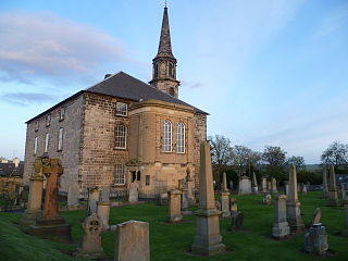
Inveresk Roman Fort is an archaeological site within the grounds of St Michael's Church, Inveresk, a village in East Lothian, Scotland.

Blewburton Hill is the site of an Iron Age hillfort located in Oxfordshire, in the southeast of England. It was a univallate hillfort. The area is mostly farmland with some small areas of wooded copse to the south and the northeast. The hill fort may have been occupied from the 4th century BC to the 1st century BC, and replaced a small settlement surrounded by a stockade, which is estimated to have been built in the 5th or 6th century BC.
Slack Roman Fort was a castellum near Outlane, to the west of Huddersfield in West Yorkshire, England. Its site is a scheduled monument. The ruins of the fort which lay alongside the Pennine section of the Roman road from Deva Victrix (Chester) to Eboracum (York) are no longer visible. The fort may have been the Cambodunum mentioned as a station on this route in the Antonine Itinerary.