
The River Leam is a river in England which rises at Hellidon Hill in Northamptonshire then flows through Warwickshire, including the town of Leamington Spa, named after it. It then flows into the River Avon near Warwick, which flows into the River Severn.

Silchester is a village and civil parish about 5 miles (8 km) north of Basingstoke in Hampshire. It is adjacent to the county boundary with Berkshire and about 9 miles (14 km) south-west of Reading.

Charlwood is a village and civil parish in the Mole Valley district of Surrey, England. It is immediately north-west of London Gatwick Airport in West Sussex, close west of Horley and north of Crawley. The historic county boundary between Surrey and Sussex ran to the south of Gatwick Airport. Boundaries were reformed in 1974 with the county boundary between Surrey and West Sussex, delineated by the Sussex Border Path, runninh along the northern perimeter of the airport, and the southern extent of Charlwood.

Ratby is a commuter village and civil parish in the Hinckley and Bosworth district of Leicestershire, England. It is situated to the west of Leicester, and just south of the M1 motorway. The population of the civil parish was measured in the 2011 census as 4,468. Other nearby places include Field Head, Kirby Muxloe, Glenfield and Markfield. The proximity of Ratby to Leicester causes it to form part of the Leicester Urban Area.

Wymeswold is a village and civil parish in the Charnwood district of Leicestershire, England. It is in the north of Leicestershire, and north-east of Loughborough. The village has a population of about 1,000, measured at 1,296 in the 2011 census. It is close to Prestwold and Burton on the Wolds in Leicestershire, and the Nottinghamshire villages of Rempstone and Willoughby on the Wolds.

Hillesley is a village in Gloucestershire, England. It was transferred from the county of Avon in 1991 and is now in Stroud District. The village forms part of the civil parish of Hillesley and Tresham. It is close to the Cotswold Edge, near the Cotswold Way and about 2+1⁄2 miles (4.0 km) south of the town of Wotton under Edge.

Woolhope is a village and civil parish in the English county of Herefordshire. The population of the civil parish was 486 at the 2011 census. The civil parish includes the hamlet of Broadmoor Common to the west of the village, and a locale known as The Nurdens also known as Upper Woolhope to its northeast.
Maltby is a village and civil parish in the borough of Stockton-on-Tees and ceremonial county of North Yorkshire, England. It is located to the east of the A19. The population of the civil parish taken at the 2011 census was 293.

Breadsall is a village and civil parish in the Borough of Erewash in Derbyshire, England. The population of the village at the 2021 census was 792 Breadsall Priory is one of the oldest buildings in the village. The village is almost contiguous with both Derby to the south and southeast and Little Eaton to the north.

Laleham Burway is a 1.6-square-kilometre (0.62 sq mi) tract of water-meadow and former water-meadow between the River Thames and Abbey River in the far north of Chertsey in Surrey. Its uses are varied. Part is Laleham Golf Club. Semi-permanent park homes in the west forms residential development along with a brief row of houses with gardens against the Thames. A reservoir and water works is on the island.
The Warwickshire Cricket League is the biggest cricket league for clubs in Warwickshire. Its origins go back to 1989, and since 1998 it has acted as a feeder league to the Birmingham and District Premier League.

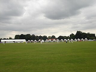
The Abbey Lawn in Bourne, Lincolnshire, England, is a centrally located space used as the principal recreation ground in the town. The cricket, tennis, bowls, pétanque, and football clubs play their home fixtures here. The hockey club practices here, though it now plays its fixtures on an all-weather pitch elsewhere. "The Lawn" is the site of the Bourne Cricket Club (Lincolnshire) and its associated facilities.

Norton Lindsey is a village and civil parish in Warwickshire, England, 3.5 miles south-west of the tourist and county town of Warwick and a mile west of the M40 motorway. At the 2011 census, the parish had a population of 326, however because the village is split between three civil parishes the population of the village is difficult to accurately determine.

Belle Vue Halt , also known as Bellevue, is an intermediate stopping place on the northern section of the Manx Electric Railway on the Isle of Man.

The Manor Sports Ground, is a cricket venue in Worthing, West Sussex, England. It is home to Worthing Cricket Club.
Manor Park is a cricket ground in Horsford, Norfolk. The ground is the main home ground of Norfolk County Cricket Club.
Brackley Cricket Club Ground is a cricket ground in Brackley, Northamptonshire. The first recorded match on the ground was in 1962, when Brackley Cricket Club moved from its original ground at Manor Road.
Cricket Hill is an unincorporated community in Mathews County, in the U.S. state of Virginia.
Prostřední Suchá is a village in Karviná District, Moravian-Silesian Region, Czech Republic. It was a separate municipality but became administratively a part of Havířov in 1960. It has a population of 4,595 (2020). The village lies in the historical region of Cieszyn Silesia.

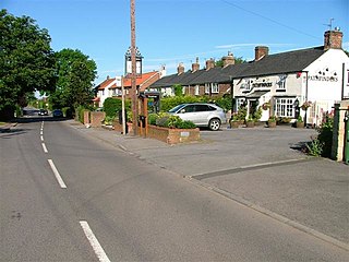
Hunningham is a medieval manor located in the West Midlands (region) of Warwickshire, England. Its location is just over three miles northeast of Leamington Spa in Warwickshire. The River Leam – located on Hellidon Hill in Northamptonshire, which then flows through rural Warwickshire, including the town of Leamington Spa – forms the Manor boundary between north and west. The Fosse Way crosses the center of the town diagonally and here is a perfectly paved road. The southeast boundary of Hunningham is formed by the River Itchen, a tributary of the Leam. Today the Manor includes the parish of Hunningham. The history of the Manor of Hunningham is of great interest because it has been documented continuously for a thousand years, from the time of the Domesday Book to the present day. However, it is assumed that the creation of the Manor of Hunningham dates back to the 9th century, but there are currently no documents to prove this.

