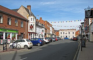
Shipston-on-Stour is a town and civil parish in the Stratford-on-Avon District in southern Warwickshire, England. It is located on the banks of the River Stour, 9 miles (15 km) south-southeast of Stratford-upon-Avon, 10 miles north-northwest of Chipping Norton, 14 miles (22 km) south of Warwick and 14.5 miles west of Banbury. In the 2021 census, Shipston-on-Stour had a population of 5,849.

Dunchurch is a village and civil parish in the Borough of Rugby, approximately 2.5 miles (4.0 km) south-west of central Rugby in Warwickshire, England. The civil parish, which also includes the nearby hamlet of Toft, had a population of 4,123 at the 2021 Census, a significant increase from 2,938 at the 2011 Census.

Wolverton is a constituent town of Milton Keynes, England. It is located in the north-west of the city, beside the West Coast Main Line, the Grand Union Canal and the river Great Ouse. It is the administrative seat of Wolverton and Greenleys civil parish.

Rockhampton is a village and civil parish in the English county of Gloucestershire, situated in the unitary district of South Gloucestershire. It is located 2.8 miles (4.5 km) northeast of Thornbury, 18.6 miles (29.9 km) north of Bristol and is approximately 4 miles (6.4 km) east of the River Severn. It had a population of 166 people according to the 2011 census.

Leek Wootton is a village and former civil parish, now in the parish of Leek Wootton and Guy's Cliffe, in the Warwick district, in the county of Warwickshire, England, approximately 2 miles south of Kenilworth and 2.5 miles north of Warwick. It lies in the triangle created by Kenilworth, Warwick and Leamington Spa. In 1961 the parish had a population of 671.

Hook Norton is a village and civil parish in Oxfordshire, England. It lies 4+1⁄2 miles (7 km) northeast of Chipping Norton, close to the Cotswold Hills. The 2011 Census recorded the parish's population as 2,117. The village is formed of four neighbourhoods: East End, Scotland End, Down End and Southrop.

Cambo is a village and former civil parish, now in the parish of Wallington Demesne, in Northumberland, England. It is about 11 miles (18 km) to the west of the county town of Morpeth at the junction of the B6342 and B6343 roads. The village was gifted along with the Wallington Estate to the National Trust by Sir Charles Philips Trevelyan in 1942, the first donation of its kind. It remains a National Trust village. In 1951 the parish had a population of 60.
Tarleton is a village and civil parish in the West Lancashire district of Lancashire, England. It is situated approximately 19 miles (31 km) north-east of Liverpool and 9 miles (14 km) south-west of Preston. The parish includes the village of Mere Brow and the hamlets of Sollom and Holmes, and is an agricultural area. It had a population of 5,959 at the 2021 Census. Tarleton village, Holmes, and the villages of Hesketh Bank and Becconsall to the north form a single built-up area with a population of 8,755.
Austrey is a village and civil parish in the North Warwickshire District of Warwickshire, England.
Wilnecote is a suburban area about two miles (3.2 km) south-east of Tamworth, in the Tamworth district, in the county of Staffordshire, England, however, it also lies within the historic county of Warwickshire. It lies between the River Tame to the west and Kettle Brook to the north and east. It is one of the largest communities in the town.
Deanshanger is a village and civil parish in West Northamptonshire, west-northwest of Milton Keynes. In 2007 it was joined with the civil parish of Wicken to form Deanshanger ward, returning two councillors. The population of the civil parish at the 2011 census was 3,817. Deanshanger is 50 miles (80 km) northwest of London, 5 miles (8.0 km) northwest of Milton Keynes and 52 miles (84 km) southeast of Birmingham.

Uppington is a village and former civil parish, now in the parish of Wroxeter and Uppington, in the Shropshire district, in the ceremonial county of Shropshire, England. It is situated 7.5 miles East from Shrewsbury and 4 miles South-East from Wellington. It is located within the Diocese of Lichfield, within the Rural Deanery of Wrockwardine. Uppington covers a total area of around 706 acres, much of this being open fields, used for arable and pastoral farming, as well as a small amount of local woodland. In 1961 the parish had a population of 86. On 1 April 1986 the parish was abolished and merged with Wroxeter to form "Uppington & Wroxeter".

Shenington is a village and former civil parish, now in the parish of Shenington with Alkerton, in the Cherwell district, in the county of Oxfordshire, England. It is about 5 miles (8 km) west of Banbury, it was an exclave of Gloucestershire until the Counties Act 1844 transferred it to Oxfordshire. Shenington is on Oxfordshire's boundary with Warwickshire. Shenington was an ancient parish of 1,628 acres (659 ha). In 1961 the parish had a population of 232. On 1 April 1970 the parish was abolished and merged with Alkerton to form "Shenington with Alkerton".
Priors Marston is a village and civil parish in the Stratford-on-Avon District of Warwickshire, England, 6 miles (9.7 km) southwest of Daventry. The Oxford Canal and Jurassic Way both run nearby. According to the 2001 Census the population of the parish is 506, increasing to 579 at the 2011 Census, most of whom live in the village. In the village's toponym, "Priors" records the fact the village belonged to St Mary's Priory in Coventry. "Marston" combines the Old English words Merse referring to a lake which formed a fishery in the early history of the village and tun meaning a settlement. The village has a primary school called The Priors School. The school was originally a state school, opened in 1847. However, in August 1996 the school was forced to close. After a month of intensive fundraising and planning the school re-opened, offering free education to village residents, and also accepting fee paying pupils from further afield. The school raised over £1.2m during 15 years of self-regulation until 1 September 2011, when it became one of the first of 22 new free schools to open in the United Kingdom. This returned the school to state funding but was independently managed.
Wolverton is a village and civil parish in the Stratford-on-Avon District of Warwickshire, England. The population at the 2011 census was 212.

Moreton Morrell is a village and civil parish in the county of Warwickshire, England. It is part of the historic hundred of Kington and is located about three and a half miles north west of the village of Kineton. The settlement was first mentioned in the Domesday Book as Moreton. From at least Norman times, it has consisted of the village of Moreton and the hamlet of Morrell. The parish of Moreton Morrell is bounded on the east and south east by the Fosse Way, and consists of Little Morrell in the north, the village of Moreton Morrell, and Moreton Paddox in the south.

Norton Juxta Twycross, usually known as simply "Norton"(or "Norton-Juxta"), is a village and former civil parish, now in the parish of Twycross, in the Hinckley and Bosworth district, in the county of Leicestershire, England. The village is part of the church parish of Appleby Magna, with the vicar based in Appleby. In 1931 the parish had a population of 249.

Honington, Warwickshire is a hamlet and civil parish in the Stratford-on-Avon District of Warwickshire, England. It is in the Brailes division of the hundred of Kington, and approximately two miles north of Shipston-on-Stour. The population taken at the 2011 census was 250. The River Stour flows past the village on the western side and has a 5-arched 17th-century bridge crossing it. Honington contains approximately 60 houses within the parish boundary, including the half-timbered Magpie Cottage, and Shoemaker's Cottage situated on the Green opposite the gates and lodge entrance to Honington Hall which was built in 1682 by Sir Henry Parker. The Church of All Saints has been re-built, but retains a 13th-century tower.

Denford is a small village and civil parish situated in North Northamptonshire, England. At the time of the 2001 census, the parish population was 250 people, increasing to 282 at the 2011 census.
Clifton is a village in the Derbyshire Dales district of Derbyshire, England. The village is situated about 1.2 miles (2 km) south west of Ashbourne, and is close to the border with Staffordshire. The appropriate civil parish is called Clifton and Compton. The population of this civil parish at the 2011 Census was 500.

