
Royal Leamington Spa, commonly known as Leamington Spa or simply Leamington, is a spa town and civil parish in Warwickshire, England. Originally a small village called Leamington Priors, it grew into a spa town in the 18th century following the popularisation of its water which was reputed to have medicinal qualities. In the 19th century, the town experienced one of the most rapid expansions in England. It is named after the River Leam, which flows through the town.

Warwick is a local government district in Warwickshire, England. It is named after the historic county town of Warwick, which is the district's second largest town; the largest town is Royal Leamington Spa, where the council is based. The district also includes the towns of Kenilworth and Whitnash and surrounding villages and rural areas. Leamington Spa, Warwick and Whitnash form a conurbation which has about two thirds of the district's population.

Kineton is a village and civil parish on the River Dene in south-east Warwickshire, England. The village is part of Stratford-on-Avon district, and in the 2001 census it had a population of 2,278, increasing to 2,337 at the 2011 Census.

Leek Wootton is a village and former civil parish, now in the parish of Leek Wootton and Guy's Cliffe, in the Warwick district, in the county of Warwickshire, England, approximately 2 miles (3.2 km) south of Kenilworth and 2.5 miles (4.0 km) north of Warwick. It lies in the triangle created by Kenilworth, Warwick and Leamington Spa. In 1961 the parish had a population of 671.

Wellesbourne is a large village in the civil parish of Wellesbourne and Walton, in the county of Warwickshire, in the West Midlands region of England. In the 2021 census the parish had a population of 7,283, a significant increase from 5,849 In the 2011 census. The civil parish was renamed from Wellesbourne to Wellesbourne and Walton on 1 April 2014.
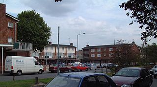
Lillington is a suburb of Leamington Spa, in the civil parish of Royal Leamington Spa, in the Warwick District in the county of Warwickshire, England. Historically a village which existed before the time of the Domesday Book (1086), it was incorporated into the borough of Leamington in 1890. Lillington is a ward of Warwick District Council and Royal Leamington Spa Town Council.

Radway is a village and civil parish in Warwickshire, England, about 7 miles (11 km) north-west of Banbury in neighbouring Oxfordshire. The population taken at the 2011 census had reduced to 238. The village is at the foot of Edge Hill and is notable for the Battle of Edgehill, one of the early major engagements of the English Civil War, which was fought in fields around the village.

Loxley, Warwickshire, is a village and civil parish near Stratford-upon-Avon, Warwickshire, England. The population taken at the 2011 census was 399. Loxley gave its name to a hall of residence at the University of Warwick, within the Westwood campus. The settlement is first mentioned in the late 8th century, as King Offa of Mercia gave it to Worcester Cathedral. The Domesday Book records the community as including a resident priest. Ownership later passed to Kenilworth Abbey. The parish church was consecrated in 1286, built on the foundation of the earlier Anglo-Saxon church. In 1538, Loxley manor was owned by Robert Croft, later passing to the Underhill family and in 1664 to Edward Nash of East Greenwich.
Keresley is a suburban village and civil parish in the City of Coventry, West Midlands, England, about 4.5 miles (7 km) north of Coventry city centre and 3.5 miles (6 km) southwest of Bedworth. According to the 2001 census, the parish had a population of 791 falling to 713 at the 2011 Census, although the 2018 population was estimated at 783.

Barford is a village and civil parish in the Warwick district of Warwickshire, England, about three miles south of Warwick. As at the 2001 census the parish had a population of 1,171, that increased to 1,336 at the 2011 census. The Joint parish council also runs the villages of Sherbourne and Wasperton. In March 2014 "The Sunday Times" listed the village as one of the Top 10 places to live in The Midlands. In the village there are two pubs, a hotel with swimming pool, and a village shop owned and run by the community.

Bishop's Tachbrook is a village and civil parish in the Warwick District of Warwickshire, England. The village is about 3 miles (5 km) south of Warwick and Leamington Spa. A church at Bishop's Tachbrook is mentioned in the Domesday Book. The village contains traditional half-timbered buildings, and modern residences including council-owned terraced housing. Facilities and amenities include The Leopard public house, the oldest part of which was a morgue for the nearby crematorium, small retail outlets including a corner shop, a primary school for children aged 4 to 11, and a park which includes a BMX track.

Bubbenhall is a village and civil parish in the Warwick district of Warwickshire, England.
Budbrooke is a village and civil parish in the Warwick district of Warwickshire, England. It is 3 miles west of Warwick and according to the 2001 census the parish had a population of 2,319, reducing to 1,863 at the 2011 Census. Most of the population of Budbrooke live in Hampton Magna, a housing estate built in the late 1960s, with other smaller settlements in Budbrooke Village and Hampton on the Hill.

Old Milverton is a hamlet east of Warwick and north west of Leamington Spa in Warwickshire, England, and situated in a bend of the River Avon. The population as taken at the 2011 census was 319.

Barford St. John is a small village and former civil parish, now in the parish of Barford St. John and St. Michael, in the Cherwell district, in the county of Oxfordshire, England. It is on the north bank of the River Swere, about 5 miles (8 km) south of Banbury. In the Middle Ages it was sometimes called Little Barford or North Barford to distinguish it from the larger village of Barford St. Michael on the opposite bank of the Swere. In 1931 the parish had a population of 53.
Fillongley, listed as Fillungeleye in 1135, is a village and civil parish in the North Warwickshire district of Warwickshire in England. The village is centred on the crossroads of the B4102 and the B4098. The population of the parish taken at the 2011 census was 1,484. It is situated 5.5 miles (8.9 km) west of Bedworth, 6.5 miles (10.5 km) south-west of Nuneaton and an equal distance north-west of Coventry. Fillongley is further from the sea than any other settlement in Great Britain, being 75 miles (120 km) from the nearest coast.

Hatton is a village and civil parish about 4 miles (6 km) west-northwest of Warwick, in the Warwick District of Warwickshire in England. The parish had a population of 1,078 at the 2001 Census, increasing to 2,319 at the 2011 Census. Notable landmarks include Hatton Locks, a series of 21 locks on the Grand Union Canal. The flight spans less than 2 miles (3.2 km) of canal, and has a total rise of 45 metres (148 ft).

Cubbington is a village and civil parish with a population of 3,929, adjoining the north-eastern outskirts of Leamington Spa, Warwickshire, England, approximately 3 miles from the town centre. Welsh Road, running through the village crossroads, was an old sheep drovers' route connecting London and Wales. Since the 1950s when the village expanded there have been two parts to the village: Cubbington proper which was the old village core, and New Cubbington which is to the west, although both are referred to as Cubbington. Topographically the highest point of the village sits about 100 metres (330 ft) above sea level while its lowest is about 60 metres (200 ft). For many years the electorate for Cubbington was represented in government by the MP for Warwick and Leamington but for the 2010 UK Elections it moved to the new Kenilworth & Southam constituency.

Moreton Morrell is a village and civil parish in the county of Warwickshire, England. It is part of the historic hundred of Kington and is located about three and a half miles north west of the village of Kineton. The settlement was first mentioned in the Domesday Book as Moreton. From at least Norman times, it has consisted of the village of Moreton and the hamlet of Morrell. The parish of Moreton Morrell is bounded on the east and south east by the Fosse Way, and consists of Little Morrell in the north, the village of Moreton Morrell, and Moreton Paddox in the south.

Preston Bagot is a village and civil parish in the Stratford district of Warwickshire, England, about 6 miles (9.7 km) west of the county town of Warwick. According to the 2001 census the population was 147, reducing to 127 at the 2011 census.


