Derventio Brigantum

Last updated

Derventio
Derventio - geograph.org.uk - 11868.jpg
Visible remains at Orchard Field, Malton showing the surviving earthworks of the north east corner of the fort
North Yorkshire UK location map (2023).svg
Archaeological site icon (red).svg
Map showing the location of Derventio within North Yorkshire.
LocationMalton, North Yorkshire
RegionYorkshire
Coordinates 54°08′10″N0°47′25″W / 54.136190°N 0.79031020°W / 54.136190; -0.79031020
TypeRoman fort
History
FoundedAD 70
Abandoned5th century
Site notes
Archaeologists Philip Corder, John Kirk, Leslie Peter Wenham
Public accessPartly in public parkland

Derventio, sometimes described as Derventio Brigantium (Latin for "Derventio of the Brigantes") in order to distinguish it from other places called Derventio, was a Roman fort and settlement located beneath the modern town of Malton in North Yorkshire, England. The fort is positioned 18 miles[ dubious ] north-east of Eboracum on the River Derwent. [2]

Contents

Site name

The Roman name for the Malton military complex first appears in the Antonine Itinerary of the late-second century. [3] [4] It is also mentioned in the fourth- or fifth-century Notitia Dignitatum as Deruentione – the last auxiliary garrison "at the disposal of the Right Honourable Duke of the Britains". [3]

Archaeological investigations

Initial investigations at the site were undertaken by Philip Corder and John Kirk in the 1930s. [5] The excavated material from this site formed the core collection of the Malton Museum. These excavations took in both the defences and interior buildings of the north-east corner of the fort and trial trenches in the south-west of the fort. [6] A further series of excavations between 1949 and 1952 by the Ministry of Works [7] in the civilian settlement uncovered multiple phases of activity as well as a road, several buildings and a mosaic. [8]

Timber and stone structures were identified during excavations on the fort in 1970 by Leslie Peter Wenham. A complex building sequence was revealed, with major phases occurring during the Trajanic, Severan, Constantian and Theodosian periods. [3] The south and west defences of an early Roman military work were confirmed beneath the vicus buildings, very likely a southern annexe of the known fort. These additional defences comprised a turf rampart 16 ft (4.9m) wide, backing a ditch 6 ft (1.8m) wide and 3½ft (1.2m) deep. [3]

Plaque recording the excavations by Philip Corder MaltonRomanPlaque.jpg
Plaque recording the excavations by Philip Corder

The fort

The earliest secure construction of a fort at Malton was in the AD 70s under Agricola, contemporary with the nearby fortress at Eboracum. Built on the north side of the River Derwent, this original phase was in timber, with the wall being rebuilt in stone in the early second century. [6] The presence of the Ala shows that for at least part of its history, Derventio was capable of housing a mounted cavalry unit.

Only a single unit has been clearly associated with occupation at this site, the Ala Gallorum Picentiana (The Picentine wing of Gauls). [3] The single record of this unit is an altar dedicated by the Prefect Candidus, from the ruins of the Severan bathhouse. [3] It remains unclear when the Ala Gallorum Picentiana were first established at Malton and when they left. However, a Hamian archers unit, known as "Numerus Syrorum Saggitariorum", served at Derventio Brigantum. [9] [ dubious ]

Civilian settlement

As with many Roman forts, a civilian settlement grew up around the established military base. The evidence at Malton shows extramural settlement surrounding the south gate of the fort and crossing to the south side of the river, following the roads leading away from the fort. [5] Many buildings were discovered, the most elaborate of which was found some 150 ft south of the fort, measured 90 ft by 30 ft and included heated floors. [8] One mid-second century structure contained circular baking ovens. [8] To the west of the road a series of rectangular buildings of an average size of 25 by 40 ft stood closely compacted together and have been interpreted as workshops or store-houses; most of the pottery from this area, including much local ware, and coin evidence dates this area to the second half of the third and the first half of the fourth century. It has been suggested that a spring in the north-east of the civilian settlement may have been the source for the bath-house, although the structure has not been located. [4] A canal, dug in 1810, destroyed any of the structures which may have been close to the line of the river. [4]

Trade and economy

The fort lies on the north banks of the River Derwent, the civilian settlement on the south site. The Roman road network provides access to the east coast and to larger settlements like Eboracum. [5]

Evidence exists for the working of bronze, iron and pewter. [5] The locally sourced jet was worked at the site into jewellery. A single inscription, from beneath the New Malton Church, offered a dedication to the genius of the place and to wish good luck to a young slave inheriting a goldsmith's shop, [5] [10] an otherwise unique inscription in Roman Britain.

Religion

No temples are currently known from Derventio. A single inscription is dedicated to Mars Rigus. [11]

Post-Roman

Malton Castle, a motte-and-bailey castle was built by the de Vesci family over the west corner of the Roman fort in the eleventh century. [4] This was demolished in the seventeenth century when a mansion was built on the site by Lord Eure, [4] [12] which was destroyed in 1674. The Dark Age settlement is the setting for much of the action in An East Wind Blowing by Australian author Mel Keegan.

Visible remains

The original earthworks are still visible in the centre of the modern town in an area known as 'Orchard Fields'. Collections from excavations at Derventio form part of the Malton Museum. [13] Roman material from Malton can also be found in the Yorkshire Museum. [14]

See also

Related Research Articles

<span class="mw-page-title-main">Canovium</span> Roman fort in Conwy, North Wales

Canovium was a fort in the Roman province of Britannia. Its site is located at Caerhun in the Conwy valley, in the county borough of Conwy, in North Wales.

<span class="mw-page-title-main">Brigantes</span> British tribe of the Iron Age and Roman era

The Brigantes were Ancient Britons who in pre-Roman times controlled the largest section of what would become Northern England. Their territory, often referred to as Brigantia, was centred in what was later known as Yorkshire. The Greek geographer Ptolemy named the Brigantes as a people in Ireland also, where they could be found around what is now Wexford, Kilkenny and Waterford, while another people named Brigantii is mentioned by Strabo as a sub-tribe of the Vindelici in the region of the Alps.

<span class="mw-page-title-main">Stamford Bridge, East Riding of Yorkshire</span> Village and civil parish in the East Riding of Yorkshire, England

Stamford Bridge is a village and civil parish on the River Derwent in the East Riding of Yorkshire, England, approximately 5 miles (8 km) east of York and 22 miles (35 km) west of Driffield. The village sits astride an ancient ford on the River Derwent.

<span class="mw-page-title-main">Eboracum</span> Ancient Roman city in present-day York, England

Eboracum was a fort and later a city in the Roman province of Britannia. In its prime it was the largest town in northern Britain and a provincial capital. The site remained occupied after the decline of the Western Roman Empire and ultimately developed into the present-day city of York, in North Yorkshire, England.

<span class="mw-page-title-main">Malton, North Yorkshire</span> Market town and civil parish in North Yorkshire, England

Malton is a market town, civil parish and electoral ward in North Yorkshire, England. Historically part of the North Riding of Yorkshire, the town has a population measured for both the civil parish and the electoral ward at the 2011 Census as 4,888.

<span class="mw-page-title-main">Dere Street</span> Roman road that ran from York in England to the Antonine Wall in Scotland

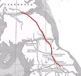
Dere Street or Deere Street is a modern designation of a Roman road which ran north from Eboracum (York), crossing the Stanegate at Corbridge and continuing beyond into what is now Scotland, later at least as far as the Antonine Wall. Portions of its route are still followed by modern roads, including the A1(M), the B6275 road through Piercebridge, where Dere Street crosses the River Tees, and the A68 north of Corbridge in Northumberland.

<span class="mw-page-title-main">Mamucium</span> Former Roman fort in the Castlefield area of Manchester in North West England

Mamucium, also known as Mancunium, is a former Roman fort in the Castlefield area of Manchester in North West England. The castrum, which was founded c. AD 79 within the Roman province of Roman Britain, was garrisoned by a cohort of Roman auxiliaries near two major Roman roads running through the area. Several sizeable civilian settlements containing soldiers' families, merchants and industry developed outside the fort. The area is a protected Scheduled Ancient Monument.

<span class="mw-page-title-main">Ambleside Roman Fort</span> Roman fort in Cumbria, United Kingdom

Luguvalium was a Roman town in northern Britain in antiquity. It was located within present-day Carlisle, Cumbria, and may have been the capital of the 4th-century province of Valentia.

<span class="mw-page-title-main">Isurium Brigantum</span> Roman fort and town at Aldborough in North Yorkshire, England

Isurium or Isurium of the Brigantes was a Roman fort and town in the province of Britannia at the site of present-day Aldborough in North Yorkshire, England, in the United Kingdom. Its remains—the Aldborough Roman Site—are in the care of English Heritage.

<span class="mw-page-title-main">Derventio Coritanorum</span> Was a small town in Roman Britannia

Derventio was a small town in the Roman province of Britannia. Today the area is known as Little Chester, on the outskirts of Derby, located in the English county of Derbyshire.

<span class="mw-page-title-main">Castleshaw Roman Fort</span> Roman camp in Greater Manchester, England

Castleshaw Roman fort was a castellum in the Roman province of Britannia. Although there is no evidence to substantiate the claim, it has been suggested that Castleshaw Roman fort is the site of Rigodunum, a Brigantian settlement. The remains of the fort are located on Castle Hill on the eastern side of Castleshaw Valley at the foot of Standedge but overlooking the valley. The hill is on the edge of Castleshaw in Greater Manchester. The fort was constructed in c. AD 79, but fell out of use at some time during the 90s. It was replaced by a smaller fortlet, built in c. 105, around which a civilian settlement grew. It may have served as a logistical and administrative centre, although it was abandoned in the 120s.

<span class="mw-page-title-main">Alauna (Maryport)</span> Roman fort and settlement on the site of present-day Maryport in Cumbria, England

Alauna was a castrum or fort in the Roman province of Britannia. It occupied a coastal site just north of the town of Maryport in the English county of Cumbria.

<span class="mw-page-title-main">Vindomora</span> Roman auxiliary fort in County Durham, England

Vindomora was an auxiliary fort on Dere Street, in the province of Lower Britain. Its ruins, now known as Ebchester Roman Fort, are situated at Ebchester in the English county of Durham, to the north of Consett and 12 miles (19 km) west-south-west from Newcastle upon Tyne.

Cataractonium was a fort and settlement in Roman Britain. The settlement evolved into Catterick, located in North Yorkshire, England.

<span class="mw-page-title-main">Derby Racecourse Roman settlement</span>

The Derby Racecourse Roman settlement was the third settlement in Derby or Derventio which was a small town in the Roman province of Britannia. It lies 600m east of Derventio fort in Little Chester, on the outskirts of Derby, in the English county of Derbyshire. The Roman road from Derventio to Sawley on the River Trent passes the settlement. It is a scheduled National Monument.

Slack Roman Fort was a castellum near Outlane, to the west of Huddersfield in West Yorkshire, England. Its site is a scheduled monument. The ruins of the fort which lay alongside the Pennine section of the Roman road from Deva Victrix (Chester) to Eboracum (York) are no longer visible. The fort may have been the Cambodunum mentioned as a station on this route in the Antonine Itinerary.

<span class="mw-page-title-main">Philip Corder</span>

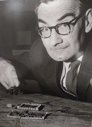
Philip Corder was a British archaeologist and curator, and president (1954-1957) of the Royal Archaeological Institute.

Derventio was a Roman settlement at Papcastle on the river Derwent near Cockermouth, Cumbria, England. It was the site of a Roman fort, which was originally built in timber and rebuilt in stone. There was also a civilian settlement (vicus). It is sometimes called Derventio Carvetiorum by modern writers to distinguish it from other places named Derventio, but there is no evidence of that extended name being used in the Roman period.

<span class="mw-page-title-main">L. P. Wenham</span> British archaeologist (1911–1990)

Leslie Peter Wenham FSA was a British archaeologist, historian, and professor who excavated in York, on Hadrian's Wall and Malton. He was the first to produce a comprehensive report of a Romano-British Cemetery.

References

  1. Antonine Itinerary. British Routes. 1st Route.
  2. The Antonine Itinerary gives the distance as 7  Roman miles. [1]
  3. 1 2 3 4 5 6 "Derventio (Brigantium)". RomanBritain.co.uk.
  4. 1 2 3 4 5 Wenham, L.P. and Haywood, B. 1997. The 1968–1970 excavations in the vicus at Malton, North Yorkshire (Yorkshire Archaeological Report no.3). Leeds: Yorkshire Archaeological Society, Roman Antiquities Section
  5. 1 2 3 4 5 Jones, R. 2009. Roman Malton. Malton: Malton Museum
  6. 1 2 Historic England (2007). "Roman Malton fort (59794)". Research records (formerly PastScape). Retrieved 21 July 2014.
  7. Mitchelson, N. 1964. 'Roman Malton: the civilian settlement. Excavations in Orchard Field, 1949–1952.' Yorkshire Archaeological Journal Vol. 41. pp209-61
  8. 1 2 3 Historic England (2007). "Roman Malton civilian settlement (59791)". Research records (formerly PastScape). Retrieved 21 July 2014.
  9. "Hamian Archers: Roman auxiliaries from Syria in Britain. 2nd Century A.D." (PDF). portalstothepast.co.uk.
  10. Collingwood, R.G. and Wright, R.P. 1965. The Roman Inscriptions of Britain. Oxford: Clarendon Press. no.712
  11. Collingwood, R.G. and Wright, R.P. 1965. The Roman Inscriptions of Britain. Oxford: Clarendon Press. no.711
  12. Historic England (2007). "Malton Lodge and Castle (59875)". Research records (formerly PastScape). Retrieved 28 July 2014.
  13. "Roman".
  14. "A ceramic vessel from Malton (YORYM : H214)". York Museums Trust. 2014. Retrieved 1 August 2014.