Birdoswald Roman Fort was known as Banna in Roman times, reflecting the geography of the site on a triangular spur of land bounded by cliffs to the south and east commanding a broad meander of the River Irthing in Cumbria below.

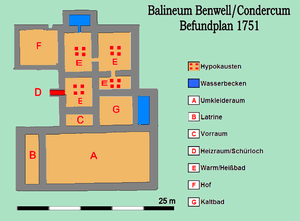
In Romano-British worship, the local god Antenociticus, also recorded as "Anociticus" at the same temple site in Benwell, was possibly worshipped as source of inspiration and intercession in military affairs.

Segedunum was a Roman fort at modern-day Wallsend, North Tyneside in North East England. The fort lay at the eastern end of Hadrian's Wall near the banks of the River Tyne. It was in use for approximately 300 years from around 122 AD to almost 400. Today Segedunum is the most thoroughly excavated fort along Hadrian's Wall, and is operated as Segedunum Roman Fort, Baths and Museum. It forms part of the Hadrian's Wall UNESCO World Heritage Site.

Arbeia was a large Roman fort in South Shields, Tyne & Wear, England, now ruined, and which has been partially reconstructed. It was first excavated in the 1870s. All modern buildings on the site were cleared in the 1970s. It is managed by Tyne and Wear Museums as Arbeia Roman Fort and Museum.

Magnis or Magna was a Roman fort near Hadrian's Wall in northern Britain. Its ruins are now known as Carvoran Roman Fort and are located near Carvoran, Northumberland, in northern England. It was built on the Stanegate frontier and Roman road, linking Coria (Corbridge) in the east to Luguvalium (Carlisle) in the west, before the building of Hadrian's Wall.
Luguvalium was an ancient Roman city in northern Britain located within present-day Carlisle, Cumbria, and may have been the capital of the 4th-century province of Valentia. It was the northernmost city of the Roman Empire.

Pons Aelius, or Newcastle Roman Fort, was an auxiliary castra and small Roman settlement on Hadrian's Wall in the Roman province of Britannia Inferior, situated on the north bank of the River Tyne close to the centre of present-day Newcastle upon Tyne, and occupied between the 2nd and 4th centuries AD.

Carrawburgh is a settlement in Northumberland. In Roman times, it was the site of a 3+1⁄2-acre (1.5 ha) auxiliary fort on Hadrian's Wall called Brocolitia, Procolita, or Brocolita.

The Vallum is a huge earthwork associated with Hadrian's Wall in England. Unique on any Roman frontier, it runs practically from coast to coast to the south of the wall. It was built a few years after the Wall.
Milecastle 18 (East Wallhouses) was a milecastle of the Roman Hadrian's Wall. It is located to the west of the settlement of East Wallhouses in Northumberland and is visible as a platform in the ground. The milecastle is of a unique construction, having a gateway associated with builders of the Legio II Augusta and a layout typical of the Legio VI Victrix or Legio XX Valeria Victrix. Historians have suggested that it may have been begun by men of one legion and finished by those of another. One of Milecastle 18's associated turrets shows evidence of being used as a workshop, possibly for the repair of shoes.

Vindobala was a Roman fort with the modern name, and in the hamlet of, Rudchester, Northumberland. It was the fourth fort on Hadrian's Wall, and situated about 11 kilometres (6.8 mi) to the west of Condercum (Benwell) fort and 7.5 miles east of Halton Chesters fort. The site of the fort is bisected by the B6318 Military Road, which runs along the route of the wall at that point.

Hunnum was a Roman fort on Hadrian's Wall located north of the modern-day village of Halton, Northumberland in North East England. It was the fifth fort on Hadrian's Wall and is situated about 7.5 miles west of Vindobala fort, 5.9 miles east of Chesters fort and 2.5 miles north of the Stanegate fort of Coria (Corbridge). The site of the fort is bisected by the B6318 Military Road, which runs along the route of the wall at that point.
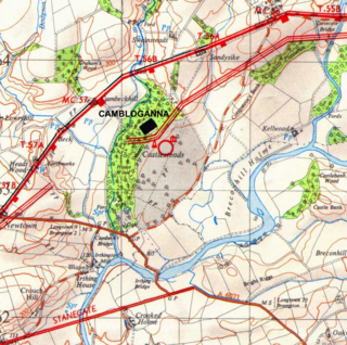
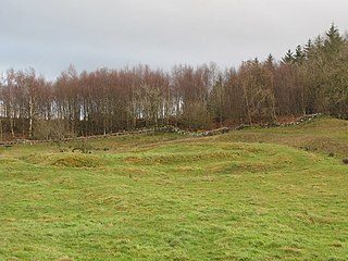
Camboglanna was a Roman fort. It was the twelfth fort on Hadrian's Wall counting from the east, between Banna (Birdoswald) almost 7 miles (11 km) to the east and Uxelodunum (Stanwix), 9 miles to the west. It was on a high bluff commanding the Cambeck Valley. It guarded an important approach to the Wall and also watched the east bank of the Cambeck against raiders from the Bewcastle area. The site was drastically levelled in 1791 when the gardens of Castlesteads House were laid over it. The name "Camboglanna" is believed to mean "Crook Bank", or "Bent Valley" because it overlooks a bend in the river Irthing; the name is Brythonic, made of cambo- "curved, bent, crooked" and glanna "steep bank, stream/river side, valley with a stream".

Aballava or Aballaba was a Roman fort on Hadrian's Wall, between Petriana (Stanwix) to the east and Coggabata (Drumburgh) to the west. It is about one and a half miles south of the Solway Firth, and its purpose was to guard the south end of two important Solway fords, the Peat Wath and the Sandwath, which were also to become favourite routes for medieval border raiders.

Hadrian's Wall is a former defensive fortification of the Roman province of Britannia, begun in AD 122 in the reign of the Emperor Hadrian. Running from Wallsend on the River Tyne in the east to Bowness-on-Solway in the west of what is now northern England, it was a stone wall with large ditches in front and behind, stretching across the whole width of the island. Soldiers were garrisoned along the line of the wall in large forts, smaller milecastles, and intervening turrets. In addition to the wall's defensive military role, its gates may have been customs posts.

Milecastle 7 (Benwell Bank or Benwell Hill) was a milecastle of the Roman Hadrian's Wall. The milecastle itself has not been discovered by archaeologists and its presumed location lies beneath a modern housing development. Roman finds have been made in the area and the associated structure of Turret 7B is a significant surviving structure of the wall.

Milecastle 19 (Matfen Piers) was a milecastle of the Roman Hadrian's Wall. Sited just to the east of the hamlet of Matfen Piers, the milecastle is today covered by the B6318 Military Road. The milecastle is notable for the discovery of an altar by Eric Birley in the 1930s. An inscription on the altar is one of the few dedications to a mother goddess found in Roman Britain, and was made by members of the First Cohort of Varduli from northern Spain. The presence of the Vardulians at this milecastle has led to debate amongst archaeologists over the origins of troops used to garrison the wall. A smaller altar was found at one of the two associated turrets.
Milecastle 29 (Tower Tye) was a milecastle of the Roman Hadrian's Wall. Its remains exist as a mutilated earth platform accentuated by deep robber-trenches around all sides, and are located beside the B6318 Military Road. Like Milecastles 9, 23, 25, and 51, a ditch has been identified around the Milecastle, and is still visible to a small extent. It has been postulated that this was as a result of the need for drainage on the site.

Milecastle 50TW (High House) was a milecastle on the Turf Wall section of Hadrian's Wall (grid reference NY60716583). The milecastle is located close to the Birdoswald Roman Fort and is unique in that it was not replaced by a stone milecastle when the turf wall was upgraded to stone, the replacement wall instead running some 200m to the north. The milecastle was partially demolished by the Romans after it was abandoned. The milecastle was excavated in 1934 and several Roman rubbish pits discovered. The remains of the two turrets associated with this milecastle (which were demolished when the turf wall was abandoned) have also been located. As the turf wall lies some distance from the stone wall, the sites are not accessible from the Hadrian's Wall Path.

Brenda Swinbank was an English archaeologist. She was one of the first women in Britain to become a professional archaeologist, specialising in the study of Hadrian's Wall, and was instrumental in bringing to publication excavations under York Minster.