Aesica

Last updated

Aesica
Northumberland, England, UK
Aesica Roman Fort - geograph.org.uk - 251498.jpg
Remains of Aesica Roman Fort (West Gate)
Northumberland UK location map.svg
Red pog.svg
Aesica
Location in Northumberland
Coordinates 54°59′42″N2°27′50″W / 54.995°N 2.464°W / 54.995; -2.464
Grid reference NY703667
Aesica on 1964 OS map 9 Aesica.png
Aesica on 1964 OS map
Great Chesters plan (with Milecastle 43 in red) Kastell Great Chesters Befundplan.png
Great Chesters plan (with Milecastle 43 in red)

Aesica (modern name Great Chesters) was a Roman fort, one and a half miles north of the small town of Haltwhistle in Northumberland, (not be confused with Chesters fort [ Cilurnum ]). It was the ninth fort on Hadrian's Wall, between Vercovicium (Housesteads) 6.0 miles to the east and Banna (Birdoswald) 6.5 miles to the west.

Contents

Its main purpose was to guard the Caw Gap where the Haltwhistle Burn crosses the Wall. [1]

Name

During the Roman period the fort was known as Æsica [2] or Esica. [3] [4]

The name Æsica may have been derived from the deity Æsus. [lower-alpha 3] If so then the name might be interpreted as:

Æsus is known to have been associated with water and river systems; the name might have been related to a remarkable aqueduct system that drew water from the Haltwhistle Burn – Caw Burn directly into the fort.

Description

Remnants of the South Gate of Aesica, with a Roman altar at centre behind the path Aesica Fort & Hadrian's Wall. - geograph.org.uk - 251501.jpg
Remnants of the South Gate of Aesica, with a Roman altar at centre behind the path

It is believed that the fort was completed in the year 128 AD, later than most of the wall forts as it was an afterthought to the original plan in which Milecastle 43 was built where the later north-west corner of the fort was constructed, and had to be demolished. [8] The fort was rectangular in plan with towers at each corner and measuring 355 feet (108 m) north to south by 419 feet (128 m) east to west, occupying a comparatively small area of 3 acres (12,000 m2). The fort had three main gates; south, east and west, with double portals with towers. At some time the west gate was completely blocked up.

Remarkably there are "broad wall" foundations of Hadrian's Wall a few metres north of the later proper "narrow gauge" wall which, unlike elsewhere, did not use the earlier foundations. This indicates the fort was started after the initial wall construction after which the later wall was used as the north wall of the fort. [9]

In addition, notably there are four ditches outside the western wall of the fort, but only a single ditch on the southern and eastern sides which indicates that the flat approach from the west was a defensive concern, while on the southern side the ditch alone interfered with the Vallum structure which clearly existed before the fort was built. [9]

The Roman Military Way entered by the east gate and left by the west gate. A branch road from the Roman Stanegate entered by the south gate which crossed the Vallum south of the fort.

A vicus lay to the south and east of the fort and several tombstones have been found there.

Roman aqueduct

The fort was supplied with water by a remarkable aqueduct system that drew water from the Haltwhistle Burn – Caw Burn directly into the fort. The aqueduct wound 6.0 miles (9.7 km) from the head of Caw Burn, north of the Wall, although the direct distance was only about 2.0 miles (3.2 km). [1] [lower-alpha 4] [lower-alpha 6]

Garrison

The 2nd-century garrisons were the Sixth Cohort of Nervians, followed by the Sixth Cohort of Raetians. The 3rd-century garrison was the Second Cohort of Asturians with a detachment of Raeti Gaeseti.

Excavations

Baths plan Befundplan Therme Great-Chesters.png
Baths plan

Excavations were carried out in 1894, during which the ramparts were cleared. A barrack block was found and headquarters building ( principia ), together with its vaulted underground strong room. The west tower of the south gate was found to contain a hoard of jewellery, which included an enamelled brooch shaped as a hare, a gilded bronze brooch described as a masterpiece of Celtic art, a silver collar with a pendant, a gold ring and a bronze ring with a Gnostic gem.

In 1897 a bathhouse was discovered, 100 yards (91 m) to the south, east of the road to the Stanegate. It includes a dressing room, latrine, cold room with cold bath, dry-heat room, warm steam room and hot steam room.

Related Research Articles

<span class="mw-page-title-main">Roman sites in Great Britain</span>

There are many Roman sites in Great Britain that are open to the public. There are also many sites that do not require special access, including Roman roads, and sites that have not been uncovered.

<span class="mw-page-title-main">Stanegate</span> Roman road that ran from Carlisle to Corbridge, England

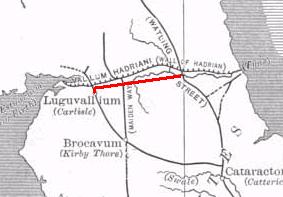
The Stanegate was an important Roman road and early frontier built in what is now northern England. It linked many forts including two that guarded important river crossings: Corstopitum (Corbridge) on the River Tyne in the east and Luguvalium (Carlisle) in the west. The Stanegate ran through the natural gap formed by the valleys of the River Tyne in Northumberland and the River Irthing in Cumbria. It predated the Hadrian's Wall frontier by several decades; the Wall would later follow a similar route, albeit slightly to the north.

<span class="mw-page-title-main">Housesteads Roman Fort</span> Roman fort in Northumberland, England

Housesteads Roman Fort was an auxiliary fort on Hadrian's Wall, at Housesteads, Northumberland, England. It is dramatically positioned on the end of the mile-long crag of the Whin Sill over which the Wall runs, overlooking sparsely populated hills. It was called the "grandest station" on the Wall and is one of the best-preserved and extensively displayed forts. It was occupied for almost 300 years. It was located 5.3 miles west from Carrawburgh fort, 6 miles east of Great Chesters fort and about two miles north east of the existing fort at Vindolanda on the Stanegate road.

<span class="mw-page-title-main">Segedunum</span> Roman fort in Tyne and Wear, England

Segedunum was a Roman fort at modern-day Wallsend, North Tyneside in North East England. The fort lay at the eastern end of Hadrian's Wall near the banks of the River Tyne. It was in use for approximately 300 years from around 122 AD to almost 400. Today Segedunum is the most thoroughly excavated fort along Hadrian's Wall, and is operated as Segedunum Roman Fort, Baths and Museum. It forms part of the Hadrian's Wall UNESCO World Heritage Site.

<span class="mw-page-title-main">Milecastle 48</span>

Milecastle 48 (Poltross Burn), is a milecastle on Hadrian's Wall (grid reference NY6340666195). Its remains lie near the village of Gilsland in Cumbria where it was historically known as "The King's Stables", owing to the well-preserved interior walls. Unusually a substantial section of stone stairs has survived within the milecastle. The two turrets associated with this milecastle have also survived as above-ground masonry.

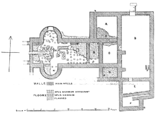
Luguvalium was an ancient Roman city in northern Britain located within present-day Carlisle, Cumbria, and may have been the capital of the 4th-century province of Valentia. It was the northernmost city of the Roman Empire.

<span class="mw-page-title-main">Cilurnum</span> Roman cavalry fort on Hadrians wall

Cilurnum or Cilurvum was an ancient Roman fort on Hadrian's Wall at Chesters near the village of Walwick, Northumberland. It is also known as Walwick Chesters to distinguish it from Great Chesters fort and Halton Chesters.

<span class="mw-page-title-main">Carrawburgh</span> Settlement in Northumberland, England

Carrawburgh is a settlement in Northumberland. In Roman times, it was the site of a 3+12-acre (1.5 ha) auxiliary fort on Hadrian's Wall called Brocolitia, Procolita, or Brocolita.

<span class="mw-page-title-main">Milecastle 18</span>

Milecastle 18 (East Wallhouses) was a milecastle of the Roman Hadrian's Wall. It is located to the west of the settlement of East Wallhouses in Northumberland and is visible as a platform in the ground. The milecastle is of a unique construction, having a gateway associated with builders of the Legio II Augusta and a layout typical of the Legio VI Victrix or Legio XX Valeria Victrix. Historians have suggested that it may have been begun by men of one legion and finished by those of another. One of Milecastle 18's associated turrets shows evidence of being used as a workshop, possibly for the repair of shoes.

<span class="mw-page-title-main">Longovicium</span> Auxiliary Roman fort in Durham county

Longovicium was an auxiliary fort located on Roman Dere Street, in the Roman province of Britannia Inferior. It is located just southwest of Lanchester in the English county of Durham, roughly 8 miles (13 km) to the west of the city of Durham and 5 miles (8 km) from Consett.

<span class="mw-page-title-main">Haltwhistle Burn</span> River in Northumberland, England

The Haltwhistle Burn is a river which lies to the east of the Northumbrian town of Haltwhistle. Rising in the peaty uplands below the ridge of the Whin Sill, the burn passes through the Roman Military Zone south of Hadrian's Wall and through a dramatic sandstone gorge before descending between wooded banks to the South Tyne Valley. The Haltwhistle Burn drains an area of approximately 42 km2. Today the Burn is a haven for wildlife and a popular walk for residents and tourists but from Roman times until the 1930s the combination of valuable minerals and water power attracted a succession of industries which provided goods and employment to the town.

<span class="mw-page-title-main">Vindobala</span> Roman fort at Northumberland, England

Vindobala was a Roman fort with the modern name, and in the hamlet of, Rudchester, Northumberland. It was the fourth fort on Hadrian's Wall, and situated about 11 kilometres (6.8 mi) to the west of Condercum (Benwell) fort and 7.5 miles east of Halton Chesters fort. The site of the fort is bisected by the B6318 Military Road, which runs along the route of the wall at that point.

<span class="mw-page-title-main">Hunnum</span> Roman fort in Northumberland, England

Hunnum was a Roman fort on Hadrian's Wall located north of the modern-day village of Halton, Northumberland in North East England. It was the fifth fort on Hadrian's Wall and is situated about 7.5 miles west of Vindobala fort, 5.9 miles east of Chesters fort and 2.5 miles north of the Stanegate fort of Coria (Corbridge). The site of the fort is bisected by the B6318 Military Road, which runs along the route of the wall at that point.

<span class="mw-page-title-main">Petriana</span> Roman fort in Cumbria, England

Uxelodunum was a Roman fort with associated civilian settlement (vicus) in modern-day Carlisle, Cumbria, England. It was the largest fort on Hadrian's Wall and is now buried beneath the suburb of Stanwix.

The Rudge Cup is a small enamelled bronze cup found in 1725 at Rudge, near Froxfield, in Wiltshire, England. The cup was found down a well on the site of a Roman villa. It is important in that it lists five of the forts on the western section of Hadrian's Wall, thus aiding scholars in identifying the forts correctly. The information on the cup has been compared with the two major sources of information regarding forts on the Wall, the Notitia Dignitatum and the Ravenna Cosmography.

<span class="mw-page-title-main">Hadrian's Wall</span> Defensive fortification in Roman Britain

Hadrian's Wall is a former defensive fortification of the Roman province of Britannia, begun in AD 122 in the reign of the Emperor Hadrian. Running from Wallsend on the River Tyne in the east to Bowness-on-Solway in the west of what is now northern England, it was a stone wall with large ditches in front of it and behind it that crossed the whole width of the island. Soldiers were garrisoned along the line of the wall in large forts, smaller milecastles, and intervening turrets. In addition to the wall's defensive military role, its gates may have been customs posts.

<span class="mw-page-title-main">Military Way (Hadrian's Wall)</span> Roman road south of Hadrians Wall

The Military Way is the modern name given to a Roman road constructed immediately to the south of Hadrian's Wall.

<span class="mw-page-title-main">Milecastle 27</span>

Milecastle 27 (Low Brunton) was a milecastle of the Roman Hadrian's Wall. It was located on the line of Hadrian's Wall, approximately midway between the A6079 and the River North Tyne. Its remains survive as a slight squarish platform with a maximum height of 0.4 metres (1.3 ft), but it is poorly defined to the north and east.

<span class="mw-page-title-main">Milecastle 43</span>

Milecastle 43 (Great Chesters) was a milecastle on Hadrian's Wall (grid reference NY70356684). It was obliterated when the fort at Great Chesters (Aesica) was built.

<span class="mw-page-title-main">Milecastle 50TW</span>

Milecastle 50TW (High House) was a milecastle on the Turf Wall section of Hadrian's Wall (grid reference NY60716583). The milecastle is located close to the Birdoswald Roman Fort and is unique in that it was not replaced by a stone milecastle when the turf wall was upgraded to stone, the replacement wall instead running some 200m to the north. The milecastle was partially demolished by the Romans after it was abandoned. The milecastle was excavated in 1934 and several Roman rubbish pits discovered. The remains of the two turrets associated with this milecastle (which were demolished when the turf wall was abandoned) have also been located. As the turf wall lies some distance from the stone wall, the sites are not accessible from the Hadrian's Wall Path.

References

  1. 1 2
    • "Hadrian's Wall - Fort - Great Chesters (Aesica)". Roman-Britain. Retrieved 1 February 2023.
  2. Notitia Dignitatum
  3. Ravenna Cosmography
  4. Rudge Cup inscription: MAIS ABALLAVA VXELODVNVM CAMBOG...S BANNA ESICA
  5. James 2019, p. 223.
  6. James 2019, p. 159.
  7. James 2019, p. 132.
  8. "Hadrian's Wall - Milecastle 43 - Great Chesters". Roman Britain. Retrieved 15 March 2024.
  9. 1 2 "Hadrian's Wall - Fort - Great Chesters (Aesica)". Roman Britain. Retrieved 15 March 2024.
  10. 1 2 Graham 1984, pp. 179.

Notes

  1. Brittonic Language ( Alan James ) < -ǭg > . . .Adjectival and nominal suffix, indicating ‘being of the kind of’, ‘association with’, ‘abounding in’, the stem-word. It occurs very widely in river-names, hill-names and other topographic names, see CPNS 447-50. . . . [5]
  2. Brittonic Language ( Alan James ) < -īg, -eg > . . .Early Celtic adjectival suffix *-ico-/ā- > -īg (masculine), -eg (feminine). The sense is similar to that of –ǭg, [lower-alpha 1] . . . [6]
  3. Brittonic Language ( Alan James ) < *Ẹ:s > . . .Early Celtic *ēs- or *ais- > Br *ẹ:s-; Latinised as Esus, Æsus, Hesus. . . .the fort-name Æsica or Esica PNRB p. 242, on Hadrian’s Wall at Great Chesters Ntb, is pretty certainly formed from the Latinised name + the Celtic adjectival suffix –icā- (see –īg) [lower-alpha 2] . . . [7]
  4. Hadrians Wall in the days of the Romans ( Frank Graham ) . . . Dr John Lingard (1771 – 1851) writing in 1807 was the first to notice the remarkable Roman aqueduct to be found here. He mentioned that the "water for the station was brought by a winding aqueduct still visible from the head of Haltwhistle Burn – Caw Burn. It winds down five miles".The aqueduct is actually six miles long but because it was necessary to wind to keep the water flow the direct line is just a little over two miles. Only one bridge was necessary and although it has gone its site is called Banks Bridge today.The aqueduct is marked on the OS map. . . . [10]
  5. Hadrians Wall in the days of the Romans ( Frank Graham ) . . . Roman aqueduct's are recorded in inscriptions from: Aqueduct channels have been identified at: . . . [10]
  6. Aesica is the only Roman fort on Hadrian's Wall known to have had such a system, although there is evidence to suggest that other forts might have used aqueduct's on a smaller scale. [lower-alpha 5]

Sources