Milefortlet 22

Last updated

Milefortlet 22
Maryport Golf Course - geograph.org.uk - 88562.jpg
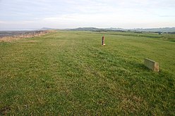
Milefortlet 22 lies beneath Maryport Golf Course
Cumbria UK location map.svg
Red pog.svg
Location within Cumbria
Type Milecastle
Location
Coordinates 54°44′10″N3°27′59″W / 54.7360°N 3.4663°W / 54.7360; -3.4663
CountyCumbria
CountryEngland
Reference
UK-OSNG reference NY05703890

Milefortlet 22 (Brownrigg) was a Milefortlet of the Roman Cumbrian Coast defences. These milefortlets and intervening stone watchtowers extended from the western end of Hadrian's Wall, along the Cumbrian coast and were linked by a wooden palisade. They were contemporary with defensive structures on Hadrian's Wall. There is little to see on the ground, but Milefortlet 22 has been located and excavated.

Contents

Description

Milefortlet 22 is situated on Maryport Golf Course in the civil parish of Crosscanonby. The site is occupied by a golf green. [1]

Excavations

The site was excavated in 1962 and 1968. The 1962 excavations revealed the ditch and rampart, and uncovered flagged floors with pottery sherds found between the stones. [1] The ditch appears to have been filled in and the fort dismantled after 140 AD. [1] The 1968 excavations revealed an entrance 1.8 metres wide in the rampart facing the cliff. Along the other three sides there was a horseshoe shaped ditch. [1] A gravel road along the cliff top turned into the fort. [1]

Associated Towers

Each milefortlet had two associated towers, similar in construction to the turrets built along Hadrian's Wall. These towers were positioned approximately one-third and two-thirds of a Roman mile to the west of the Milefortlet, and would probably have been manned by part of the nearest Milefortlet's garrison. The towers associated with Milefortlet 22 are known as Tower 22A (grid reference NY05293861 ) and Tower 22B (grid reference NY04863830 ). [2] [3] Tower 22A is identified with a low turf-covered mound, 10 centimetres high, on Maryport Golf Course. [2] The location of Tower 22B is uncertain. [3]

Related Research Articles

<span class="mw-page-title-main">Milecastle 80</span>

Milecastle 80 was one of a series of Milecastles or small fortlets built at intervals of approximately one Roman mile along Hadrian's Wall.

<span class="mw-page-title-main">Milefortlet 21</span>

Milefortlet 21 (Swarthy Hill) was a Milefortlet of the Roman Cumbrian Coast defences. These defences were contemporary with defensive structures on Hadrian's Wall. Its remains exist as reconstructed turf ramparts (to a height of about 1 metre (3.3 ft)) and ditch, reinstated to its original profile (also around 1 metre (3.3 ft)). They are located on a low cliff on the coast, north of the village of Crosscanonby, and just inland from the coastal road. It is the only milefortlet to have been fully excavated and is open to the public.

<span class="mw-page-title-main">Turret (Hadrian's Wall)</span> Small watch tower on Hadrians Wall

A turret was a small watch tower, incorporated into the curtain wall of Hadrian's Wall. The turrets were normally spaced at intervals of one third of a Roman mile between Milecastles, giving two Turrets between each Milecastle.

<span class="mw-page-title-main">Milefortlet 1</span>

Milefortlet 1 (Biglands House) was a milefortlet of the Roman Cumbrian Coast defences. These milefortlets and intervening stone watchtowers extended from the western end of Hadrian's Wall, along the Cumbrian coast and were linked by a wooden palisade. They were contemporary with defensive structures on Hadrian's Wall. The remains of Milefortlet 1 survive as a slight earthwork.

<span class="mw-page-title-main">Milefortlet 3</span>

Milefortlet 3 (Pasture House) was a Milefortlet of the Roman Cumbrian Coast defences. These milefortlets and intervening stone watchtowers extended from the western end of Hadrian's Wall, along the Cumbrian coast and were linked by a wooden palisade. They were contemporary with defensive structures on Hadrian's Wall. There is little to see on the ground but Milefortlet 3 has been located on aerial photographs.

<span class="mw-page-title-main">Milefortlet 4</span>

Milefortlet 4 (Herd Hill) was a Milefortlet of the Roman Cumbrian Coast defences. These milefortlets and intervening stone watchtowers extended from the western end of Hadrian's Wall, along the Cumbrian coast and were linked by a wooden palisade. They were contemporary with defensive structures on Hadrian's Wall. There is little to see on the ground but Milefortlet 4 has been located by archaeologists.

<span class="mw-page-title-main">Milefortlet 5</span>

Milefortlet 5 (Cardurnock) was a Milefortlet of the Roman Cumbrian Coast defences. These milefortlets and intervening stone watchtowers extended from the western end of Hadrian's Wall, along the Cumbrian coast and were linked by a wooden palisade. They were contemporary with defensive structures on Hadrian's Wall. The remains of Milefortlet 5 was excavated in 1943-4 prior to its destruction in 1944.

<span class="mw-page-title-main">Milefortlet 9</span>

Milefortlet 9 (Skinburness) was a Milefortlet of the Roman Cumbrian Coast defences. These milefortlets and intervening stone watchtowers extended from the western end of Hadrian's Wall, along the Cumbrian coast and were linked by a wooden palisade. They were contemporary with defensive structures on Hadrian's Wall. There is little to see on the ground but Milefortlet 9 has been located on aerial photographs.

Milefortlet 12 (Blitterlees) was a Milefortlet of the Roman Cumbrian Coast defences. These milefortlets and intervening stone watchtowers extended from the western end of Hadrian's Wall, along the Cumbrian coast and were linked by a wooden palisade. They were contemporary with defensive structures on Hadrian's Wall. There is little to see on the ground but Milefortlet 12 has been located and excavated. The milefortlet is located close to the hamlet of Blitterlees, in the civil parish of Holme Low.

Milefortlet 16 was a Milefortlet of the Roman Cumbrian Coast defences. These milefortlets and intervening stone watchtowers extended from the western end of Hadrian's Wall, along the Cumbrian coast and were linked by a wooden palisade. They were contemporary with defensive structures on Hadrian's Wall. There is little to see on the ground but Milefortlet 16 has been located.

<span class="mw-page-title-main">Milefortlet 17</span>

Milefortlet 17 (Dubmill Point) was a Milefortlet of the Roman Cumbrian Coast defences. These milefortlets and intervening stone watchtowers extended from the western end of Hadrian's Wall, along the Cumbrian coast and were linked by a wooden palisade. They were contemporary with defensive structures on Hadrian's Wall. There is little to see except a slight depression in the ground, but Milefortlet 17 has been located and surveyed.

Milefortlet 20 (Low Mire) was a Milefortlet of the Roman Cumbrian Coast defences. These milefortlets and intervening stone watchtowers extended from the western end of Hadrian's Wall, along the Cumbrian coast and were linked by a wooden palisade. They were contemporary with defensive structures on Hadrian's Wall. There is little to see on the ground, but Milefortlet 20 has been located and excavated.

<span class="mw-page-title-main">Milefortlet 23</span>

Milefortlet 23 (Sea Brows) was a Milefortlet of the Roman Cumbrian Coast defences. These milefortlets and intervening stone watchtowers extended from the western end of Hadrian's Wall, along the Cumbrian coast and were linked by a wooden palisade. They were contemporary with defensive structures on Hadrian's Wall. There is nothing to see on the ground, but Milefortlet 23 has been located and surveyed.

<span class="mw-page-title-main">Milefortlet 2</span>

Milefortlet 2 was a Milefortlet of the Roman Cumbrian Coast defences. These milefortlets and intervening stone watchtowers extended from the western end of Hadrian's Wall, along the Cumbrian coast and were linked by a wooden palisade. They were contemporary with defensive structures on Hadrian's Wall. The exact location of Milefortlet 2 is unknown, although one of the nearby turrets has been located and excavated.

<span class="mw-page-title-main">Milefortlet 13</span>

Milefortlet 13 was a Milefortlet of the Roman Cumbrian Coast defences. These milefortlets and intervening stone watchtowers extended from the western end of Hadrian's Wall, along the Cumbrian coast and were linked by a wooden palisade. They were contemporary with defensive structures on Hadrian's Wall. The exact location of Milefortlet 13 is unknown, although two of the nearby turrets have been located and excavated.

<span class="mw-page-title-main">Milefortlet 15</span>

Milefortlet 15 was a Milefortlet of the Roman Cumbrian Coast defences. These milefortlets and intervening stone watchtowers extended from the western end of Hadrian's Wall, along the Cumbrian coast and were linked by a wooden palisade. They were contemporary with defensive structures on Hadrian's Wall. The site of Milefortlet 15 has been probably been destroyed by coastal erosion. A 3rd-century Roman cemetery, associated with a nearby fort at Beckfoot, was located in the area of the milefortlet.

<span class="mw-page-title-main">Milefortlet 14</span>

Milefortlet 14 was a Milefortlet of the Roman Cumbrian Coast defences. These milefortlets and intervening stone watchtowers extended from the western end of Hadrian's Wall, along the Cumbrian coast and were linked by a wooden palisade. They were contemporary with defensive structures on Hadrian's Wall. The site of Milefortlet 14 has never been identified and it may lie beneath the village of Beckfoot. A larger fort known as Bibra Roman Fort was located 500 metres south-west of Milefortlet 14.

<span class="mw-page-title-main">Milefortlet 25</span>

Milefortlet 25 was a Milefortlet of the Roman Cumbrian Coast defences. These milefortlets and intervening stone watchtowers extended from the western end of Hadrian's Wall, along the Cumbrian coast and were linked by a wooden palisade. They were contemporary with defensive structures on Hadrian's Wall. Milefortlet 25 is the southernmost known of the fortlets of the Cumberland coast, but there is nothing to see on the ground, as Milefortlet 25 lies in an industrial area of Maryport.

<span class="mw-page-title-main">Milefortlet 11</span>

Milefortlet 11 was a Milefortlet of the Roman Cumbrian Coast defences. These milefortlets and intervening stone watchtowers extended from the western end of Hadrian's Wall, along the Cumbrian coast and were linked by a wooden palisade. They were contemporary with defensive structures on Hadrian's Wall. Milefortlet 11 has never been accurately located on the ground although other Roman remains have been found in the area.

<span class="mw-page-title-main">Milecastle 50TW</span>

Milecastle 50TW (High House) was a milecastle on the Turf Wall section of Hadrian's Wall (grid reference NY60716583). The milecastle is located close to the Birdoswald Roman Fort and is unique in that it was not replaced by a stone milecastle when the turf wall was upgraded to stone, the replacement wall instead running some 200m to the north. The milecastle was partially demolished by the Romans after it was abandoned. The milecastle was excavated in 1934 and several Roman rubbish pits discovered. The remains of the two turrets associated with this milecastle (which were demolished when the turf wall was abandoned) have also been located. As the turf wall lies some distance from the stone wall, the sites are not accessible from the Hadrian's Wall Path.

References

  1. 1 2 3 4 5 Historic England. "BROWNRIGG MILEFORTLET 22 (8970)". Research records (formerly PastScape). Retrieved 26 November 2013.
  2. 1 2 Historic England. "MARYPORT GOLF COURSE TOWER 22A (8976)". Research records (formerly PastScape). Retrieved 26 November 2013.
  3. 1 2 Historic England. "TOWER 22B (1023975)". Research records (formerly PastScape). Retrieved 26 November 2013.