
Rottweil is a town in southwest Germany in the state of Baden-Württemberg. Rottweil was a free imperial city for nearly 600 years.
Eric Breuer is a Swiss archaeologist and historian.

The Kinzig is a river in southwestern Germany, a right tributary of the Rhine.

Upper Swabia is a region in Germany in the federal states of Baden-Württemberg and Bavaria. The name refers to the area between the Swabian Jura, Lake Constance and the Lech. Its counterpart is Lower Swabia (Niederschwaben), the region around Heilbronn.
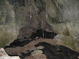
Geissenklösterle is an archaeological site of significance for the central European Upper Paleolithic, located near the town of Blaubeuren in the Swabian Jura in Baden-Württemberg, southern Germany. First explored in 1963, the cave contains traces of early prehistoric art from between 43,000 and 30,000 years ago, including some of the oldest-known musical instruments and several animal figurines. Because of the historical and cultural importance of these findings, in 2017 the site became part of the UNESCO World Heritage Site Caves and Ice Age Art in the Swabian Jura.
Rottenmünster Abbey, also the Imperial Nunnery of Rottenmünster, was a Cistercian abbey located near Rottweil in Baden-Württemberg. The self-ruling Imperial Abbey was secularized in the course of the German mediatization of 1802–1803 and its territory annexed to the Duchy of Württemberg. The monastery was closed in 1850. The buildings of the former abbey now house a hospital.

The Upper Germanic-Rhaetian Limes, or ORL, is a 550-kilometre-long section of the former external frontier of the Roman Empire between the rivers Rhine and Danube. It runs from Rheinbrohl to Eining on the Danube. The Upper Germanic-Rhaetian Limes is an archaeological site and, since 2005, a UNESCO World Heritage Site. Together with the Lower Germanic Limes it forms part of the Limes Germanicus.

The Roman fort at Weissenburg, called Biriciana in ancient times, is a former Roman ala castellum, which is a UNESCO World Heritage Site located near the Upper Germanic-Rhaetian Limes. It lies in the borough of Weißenburg in the Middle Franconian county of Weißenburg-Gunzenhausen in Germany. Today the castellum is one of the most important sites of research in the Roman limes in Germany. The site contains partly subterranean building remains, a reconstructed north gateway, large thermal baths and a Roman Museum with an integrated Limes Information Centre.

The Lower Germanic Limes is the former frontier between the Roman province of Germania Inferior and Germania Magna. The Lower Germanic Limes separated that part of the Rhineland left of the Rhine as well as the southern part of the Netherlands, which was part of the Roman Empire, from the less tightly controlled regions east of the Rhine.

The Neckar-Odenwald Limes is a collective term for two, very different early sections of the Upper Germanic-Rhaetian Limes, a Roman defensive frontier line that may have been utilised during slightly different periods in history. The Neckar-Odenwald Limes consists of the northern Odenwald Limes (Odenwaldlimes), a cross-country limes with camps, watchtowers and palisades, which linked the River Main with the Neckar, and the adjoining southern Neckar Limes (Neckarlimes), which in earlier research was seen as a typical 'riverine limes', whereby the river replaced the function of the palisade as an approach obstacle. More recent research has thrown a different light on this way of viewing things that means may have to be relativized in future. The resulting research is ongoing.
The Pannonian Limes is part of the old Roman fortified frontier known as the Danubian Limes that runs for approximately 420 km (260 mi) from the Roman camp of Klosterneuburg in the Vienna Basin in Austria to the castrum in Singidunum (Belgrade) in present-day Serbia. The garrisons of these camps protected the Pannonian provinces against attacks from the north from the time of Augustus (31 BC–14 AD) to the beginning of the 5th century. In places this section of the Roman limes also crossed the river into the territory of the barbarians (Barbaricum).
Pfünz Roman Fort, Castra Vetoniana or Vetonianae, was a Roman cohort camp near Pfünz, a village in the municipality of Walting in the county of Eichstätt, Bavaria. It was built in about 90 A. D. on a 42-metre-high Jurassic hillspur between the valley of the Altmühl and that of the Pfünzer Bach stream. it is a component of the Rhaetian Limes which was elevated in 2005 to the status of a UNESCO World Heritage Site. Of historical importance are the remains of the double V-shaped ditches hewn out of the rock in front of the position, the one on the western rampart being the best preserved. In 1998, as part of the construction of a high pressure water system, the Bavarian State Office for Monument Protection carried out further test excavations. The archaeological record and rich finds from Pfünz, some of which are very rare, are seen as reasons for further studies in the future.
The Main Limes, also called the Nasser Limes, was built around 90 AD and, as part of the Upper Germanic-Rhaetian Limes, formed the frontier of the Roman Empire in the area between the present day villages of Großkrotzenburg and Bürgstadt. In this section the limes adjoined the River Main (Moenus), which forms a natural boundary for about 50 kilometres here, so "Main" refers to the river.

The Wetterau Limes is the name given in the field of historical research to that part of the Upper Germanic-Rhaetian Limes which enclosed the region that became known later as the Wetterau in the German state of Hesse.
The Lautertal Limes is a Roman limes section of the early 2nd century which is located between the River Neckar and the Swabian Jura. It extends for a distance of 23 kilometres (14 mi), running, straight as a die, from the present-day municipality of Köngen on the Neckar in the northwest to Donnstetten in the Swabian Jura to the southeast.
The Danube–Iller–Rhine Limes or DIRL was a large-scale defensive system of the Roman Empire that was built after the project for the Upper Germanic-Rhaetian Limes in the late 3rd century AD. In a narrower sense the term refers only to the fortifications between Lake Constance and the River Danube (Danubius); in a broader sense it also includes the other Late Roman fortifications along the river Rhine (Rhenus) on the High Rhine and on the Upper Rhine as well as the Upper Danube.
The Limesfall is the name given to the abandonment of the Upper Germanic-Rhaetian Limes in the mid-3rd century AD by the Romans and the withdrawal of imperial troops from the provinces on the far side of the rivers Rhine and Danube to the line of those rivers. It is sometimes called the fall of the limes.
Matthias Untermann is a German art historian and medieval archaeologist.
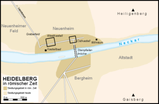
During ancient Rome, a settlement of unknown name existed at the site of Heidelberg. It consisted of a fort founded around 70 AD in the present-day district of Neuenheim and a civilian settlement (vicus) that developed around the fort and also extended into the present-day district of Bergheim. The original wooden military camp was replaced by a stone fort around the year 90. In 80/90 there was a wooden bridge over the Neckar, and in 200 there was a bridge built on stone pillars. Even after the garrison of the Heidelberg fort was withdrawn around the year 135, the civilian settlement continued to flourish thanks to its favorable geographical location and developed into a prosperous pottery center. Nevertheless, Heidelberg always remained in the shadow of neighboring Lopodunum, which was the main city of the region at the time. As a result of the Alamanni invasions, Roman Heidelberg was abandoned in the 3rd century as part of the so-called Limesfall.

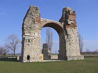
The Limes Gate in Dalkingen is a unique Roman triumphal monument on the Upper Germanic-Rhaetian Limes and is one of its most impressive ruins. Since 2005, the ancient border passage, which was developed into a triumphal gate under Emperor Caracalla, is a UNESCO World Heritage Site, together with the entire Roman Limes complex in Germany. It is also part of the open-air museum of the Rhaetian Limes, which was established in 1972 and also includes the nearby Buch fort and its civilian settlement. The gate, which was declared a cultural monument in 2006, is located between the villages of Schwabsberg and Dalkingen in the Ostalbkreis district of Baden-Württemberg.