
Wandsworth is a London borough in southwest London; it forms part of Inner London and has an estimated population of 329,677 inhabitants. Its main named areas are Battersea, Balham, Putney, Tooting and Wandsworth Town.
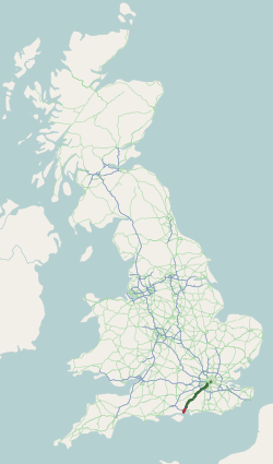
The A3, known as the Portsmouth Road or London Road in sections, is a major road connecting the City of London and Portsmouth passing close to Kingston upon Thames, Guildford, Haslemere and Petersfield. For much of its 67-mile (108 km) length, it is classified as a trunk road and therefore managed by National Highways. Almost all of the road has been built to dual carriageway standards or wider. Apart from bypass sections in London, the road travels in a southwest direction and, after Liss, south-southwest.

Clapham Junction railway station is a major railway station and transport hub near St John's Hill in south-west Battersea in the London Borough of Wandsworth. It is 2 miles 57 chains from London Victoria and 3 miles 74 chains from London Waterloo; it is on both the South West Main Line and Brighton Main Line as well as numerous other routes and branch lines passing through or diverging from the main lines at this station. Despite its name, Clapham Junction is not located in Clapham, a district situated approximately 1 mile (1.6 km) to the south-east and is instead sited in Battersea.

The A23 road is a major road in the United Kingdom between London and Brighton, East Sussex, England. It is managed by Transport for London for the section inside the Greater London boundary, Surrey County Council and West Sussex County Council for the section shadowed by the M23 motorway, National Highways between the M23 and Patcham, and by Brighton and Hove Council from the A27 to the centre of Brighton.

Haywards Heath is a town in West Sussex, England, 36 miles (58 km) south of London, 14 miles (23 km) north of Brighton, 13 miles (21 km) south of Gatwick Airport and 31 miles (50 km) northeast of the county town, Chichester. Nearby towns include Burgess Hill to the southwest, Horsham to the northwest, Crawley northwest and East Grinstead northeast. With only a relatively small number of jobs available in the immediate vicinity, mostly in the agricultural or service sector, many residents work "remotely" or commute daily via road or rail to London, Brighton, Crawley or Gatwick Airport for work.

The National Cycle Network (NCN) is the national cycling route network of the United Kingdom, which was established to encourage cycling and walking throughout Britain, as well as for the purposes of bicycle touring. It was created by the charity Sustrans who were aided by a £42.5 million National Lottery grant. However Sustrans themselves only own around 2% of the paths on the network, these rest being made of existing public highways and rights of way, and permissive paths negotiated by Sustrans with private landowners, which Sustrans have then labelled as part of their network.
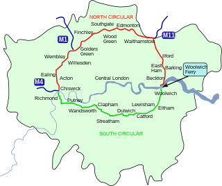
The South Circular Road in south London, England, is a major road that runs from the Woolwich Ferry in the east to the Chiswick Flyover in the west via Eltham, Lee Green, Catford, Forest Hill, Dulwich, Tulse Hill, Clapham Common, Clapham Junction, Wandsworth, Putney, Barnes, Mortlake and Kew Bridge. Together with the North Circular Road and Woolwich Ferry, it makes a complete ring-road around Central London and forms the boundary of the Ultra Low Emission Zone. The South Circular is largely a sequence of urban streets joined together, requiring several at-grade turns, unlike the mostly purpose-made carriageways of the North Circular. As a result, it is frequently congested.

Wandsworth Road railway station is a National Rail station between Battersea and Clapham in south London. It is served by London Overground services between Clapham Junction and Dalston Junction, with a limited service to Battersea Park. It is 1 mile 75 chains (3.1 km) from London Victoria.
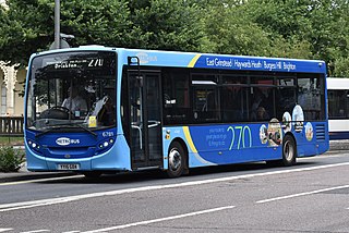
Metrobus is a bus operator with routes in parts of Surrey, Kent, Sussex, and Greater London. Formed through a management buyout in 1983, Metrobus was purchased by the Go-Ahead Group in September 1999.
London to Brighton refers to a variety of races, tours, charity bicycle rides and rallies that take place between London and Brighton in the United Kingdom.

Furnace Green is one of 14 neighbourhoods in Crawley in West Sussex, England, and a local government ward. Furnace Green is located to the east of the town centre. It is bordered by Tilgate to the south west, Three Bridges to the north and Maidenbower to the east.

The Brighton Main Line is a major railway line in the United Kingdom that links Brighton, on the south coast of England, with central London. In London the line has two branches, out of London Victoria and London Bridge stations respectively, which join up in Croydon and continue towards Brighton as one line. The line is electrified throughout using the third rail system.

The A217 is a road in London and Surrey in England. It runs north–south. It runs from Kings Road in Fulham, London, crosses the Thames at Wandsworth Bridge, then passes through Wandsworth, Earlsfield, Summerstown, Tooting, Mitcham, Rosehill and Sutton Common in Sutton, then Cheam. Then, widened as a dual carriageway, comes Belmont, a suburban district built on a slope rising southward. On the North Downs in Surrey the road then skirts past Banstead and through its late 19th century offspring villages particularly Burgh Heath and Kingswood, Surrey. It then crosses the M25 motorway at Junction 8, then, returning to single carriageways, passes through the castle town of Reigate. It then cuts through the green buffer farmland of two rural villages and terminates at the road network at Gatwick Airport's northern perimeter.

Pyecombe is a village and civil parish in the Mid Sussex District of West Sussex, England. The name 'Pyecombe' may derive from the Saxon "pic" meaning point or pike, in which case it may mean "valley marked by a projecting hill".

The Worth Way is a 7-mile (11 km) footpath and bridleway linking the West Sussex towns of Crawley and East Grinstead via the village of Crawley Down. Mostly following the trackbed of a disused railway the path is an important wildlife corridor. It is part of the National Cycle Network.

Balham is an interchange station formed of a range of underground entrances for the London Underground ('tube') and a shared entrance with its National Rail station component. The station is in central Balham in the London Borough of Wandsworth, south London, England. The tube can be accessed on each side of the Balham High Road (A24); National Rail on the south side of the road leading east, where the track is on a mixture of light-brick high viaduct and earth embankment, quadruple track and on a brief east–west axis.

Patcham is an area of the city of Brighton & Hove, about 3 miles (5 km) north of the city centre. It is bounded by the A27 to the north, Hollingbury to the east and southeast, Withdean to the south and the Brighton Main Line to the west. The A23 passes through the area.

National Cycle Route 1 is a route of the National Cycle Network, running from Dover to Tain. The 1,264 mi-long (2,034-kilometre) cycle-path is located in the United Kingdom.
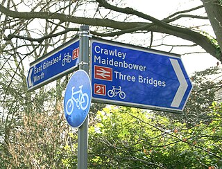
National Cycle Route 21 is part of the United Kingdom's National Cycle Network. It runs from Greenwich in South-East London south to Crawley, then east to Groombridge and south to Eastbourne, with a short final loop northwards again to its end at Pevensey.

The London to Brighton Way, also called the London to Portslade Way, is a Roman road between Stane Street at Kennington Park and Brighton in Sussex. The road passes through Streatham and Croydon, then through the Caterham Valley gap in the North Downs. It passes through Godstone and Felbridge, then follows an almost straight line through Ardingly, Haywards Heath, Burgess Hill and Hassocks to the South Downs at Clayton. At Hassocks it crosses the Sussex Greensand Way at a large Roman cemetery. It climbs the South Downs escarpment, crossing the ridgeway and connecting with other local tracks. South of Pyecombe the route is uncertain, and may have continued to Brighton or to Portslade.
