National Cycle Route 65

Last updated

NCN Route 65
NCN-route71-route-65-signs.jpg
National Cycle Network signpost in Kirby Knowle, North Yorkshire.
Length214 km (133 mi)
LocationYorkshire, UK
Established1998
Designation UK National Cycle Network
Trailheads Hornsea (south) to Middlesbrough (north)
UseCycling
Highest pointSilton Forest, 305 m (1,001 ft)
Lowest pointHornsea, 0 m (0 ft)
DifficultyModerate
Waymark NCN arrow sign 65.svg
Website Official website
Trail map
NCN route 65 on OpenStreetMap.jpg

National Cycle Network (NCN) Route 65 is a Sustrans National Route that runs from Hornsea on the North Sea Coast of The East Riding of Yorkshire via Hull and York to Middlesbrough. It is fully open and signed.

Contents

Between Hornsea and York it forms the eastern end of the Trans Pennine Trail. The section between York and Linton-on-Ouse is part of the Way of the Roses. In 1998 Route 65 between Hull and Middlesbrough was branded The White Rose cycle route. [1] This branding is no longer in use.

Route

National Cycle
Route 65
BSicon flCONTg@F.svg
BSicon numN030.svg
mi
BSicon fSTRl.svg
BSicon fTEEa.svg
BSicon fLSTR+r.svg
  1 (↑ N│S ↓)
BSicon fENDE.svg
0
BSicon cRP2q.svg
BSicon fBHF.svg
BSicon RP2q.svg
BSicon cRP2q.svg
1
Middlesbrough
BSicon fABZg+l.svg
BSicon fCONTfq.svg
13
  165 to E
BSicon fHST.svg
13
Hutton Rudby
BSicon fCONTgq.svg
BSicon fABZgr.svg
13
  165 to W
BSicon fGDTgg.svg
18
BSicon fABZg2.svg
BSicon fSTRc3.svg
22
  656 to E
BSicon fSTRc1.svg
BSicon fGDTff.svg
BSicon MASKe.svg
BSicon fLSTR+4.svg
BSicon fSTR+4.svg
24
BSicon fSTRc2.svg
BSicon fSTRc2.svg
BSicon fABZg3.svg
BSicon MASKa.svg
BSicon fLSTR3.svg
BSicon fSTR3.svg
30
  657 to E
BSicon fSTR+1.svg
BSicon fSTRc4.svg
BSicon fABZg+1.svg
BSicon fSTRc4.svg
39
  656 to W
BSicon fLSTR.svg
BSicon fHST.svg
39
Coxwold
BSicon fSTR2.svg
BSicon fSTRc3.svg
BSicon fHST.svg
44
Easingwold
BSicon fSTRc1.svg
BSicon fABZg+4.svg
45
  657 to W
BSicon fCONTgq.svg
BSicon fTEEr.svg
53
Linton-on-Ouse   688 to W
BSicon dWASSER.svg
BSicon fcSTR.svg
BSicon HOUSE.svg
55
Beningbrough Hall
BSicon fTEEl.svg
BSicon fCONTfq.svg
64
  658 to E
BSicon fhbKRZWae.svg
River Ouse
BSicon cRP2q.svg
BSicon fBHF.svg
BSicon RP2q.svg
BSicon cRP2q.svg
64
York
BSicon fABZg+l.svg
BSicon fCONTfq.svg
65
  66 to E
BSicon fSTR.svg
BSicon fCONTgq.svg
BSicon fABZgr.svg
68
  66 to W
BSicon fhbKRZWae.svg
68
River Ouse
BSicon fCONTgq.svg
BSicon fTEEr.svg
78
  62 to W
BSicon cRP2q.svg
BSicon fBHF.svg
BSicon RP2q.svg
BSicon cRP2q.svg
78
Selby
BSicon dWASSER.svg
BSicon fcSTR.svg
BSicon fHST.svg
89
Howden
BSicon dWASSER3.svg
BSicon fcSTR.svg
BSicon fGDTfg.svg
107
Welton
BSicon dWASSER+4.svg
BSicon fcSTR.svg
BSicon fSKRZ-G4u.svg
112
Humber Bridge A15
BSicon fCONT3+l.svg
BSicon fABZg+r.svg
113
Hessle   1 to S
BSicon fABZgl.svg
BSicon fLSTRr.svg
114
  1 to N
BSicon cRP2q.svg
BSicon fBHF.svg
BSicon RP2q.svg
BSicon cRP2q.svg
118
Hull
BSicon fSTR+l.svg
BSicon fABZg+r.svg
119
  66 to E
BSicon flCONTf@G.svg
BSicon fSTRl.svg
BSicon fSTR2.svg
BSicon fSTRc3.svg
BSicon fCONT1+r.svg
120
  66 to N
BSicon fSTRc1.svg
BSicon fKBHF4.svg
133
Hornsea

Hornsea to Hull

This part of the route runs almost entirely along the dismantled trackbed of the Hull and Hornsea Railway and is known as the Hornsea Rail Trail. The path takes a straight route over the flat Holderness plain [2] and is 15 miles (24 km) in length. [3]

Hull to York

Cycle route on former ECML route between Escrick and Naburn Bridge across former East Coast Main Line route - geograph.org.uk - 877006.jpg
Cycle route on former ECML route between Escrick and Naburn

Route 65 avoids the Yorkshire Wolds by running along the banks of the Humber Estuary, passing under the Humber Bridge. A very flat route, there is a small climb at Welton. [4] Mainly on quiet country lanes as far as Selby, there are several short traffic-free sections. From Selby to York the route [5] uses the trackbed of the old East Coast Mainline railway, which was bought by Sustrans for £1 and turned into one of its first traffic-free paths. [6] On a 10 kilometres (6.2 mi) section of this path is a scale model of the Solar System. [7]

NCN Route 66 provides an alternative route between Hull and York.

York to Middlesbrough

Following a traffic-free route out of York, the rest of the route is almost entirely on quiet country lanes. North of York, NCN 65 passes Beningbrough Hall. There are two routes here, the path through the National Trust grounds is one-way, so the northbound path is routed around the perimeter. At Easingwold, Route 65 leaves the flat for the first time as it approaches the North York Moors. Running along the foothills there are several short steep climbs/descents. The route climbs over the North Western edge of the North York Moors, passing to the east of Osmotherley. Its high point is reached via a long steep climb up a forestry commission path. The route in Middlesbrough is mainly traffic free.

Route 65 forms part of the Way of the Roses Challenge route [8] between York (junction with NCN 658) and Linton-on-Ouse (junction with NCN 688).

Developments

The route through York was improved in April 2019 with the Scarborough Bridge improvements. [9] The steep steps and narrow deck have been replaced by ramps and a 3.7m wide path. [10]

History

The original route north of York consisted of three branches all numbered as Route 65. [11] In 2009 Sustrans introduced 3 digit numbers for shorter local routes [12] and two of the three branches of Route 65 were renumbered. The Thirsk branch became Route 657 and the High Level Option is now Route 656. The Low Level Option remains as Route 65.

Millennium Mileposts

There are over 1,000 Mileposts on the National Cycle Network. [13] A number of the mileposts are located on Route 65.

Sustrans IDMilepost TypeLocationcoordinatesPhoto
MP5MillsYork to Beningbrough path 53°59′36″N1°08′19″W / 53.99325°N 1.1386°W / 53.99325; -1.1386
Sustrans MP5 20090731.jpg
MP96MillsSelby 53°47′21″N1°02′47″W / 53.7893°N 1.0464°W / 53.7893; -1.0464
MP97MillsRiccall Mound 53°50′25″N1°03′22″W / 53.8404°N 1.0562°W / 53.8404; -1.0562
Sustrans MP97 20100523.jpg
MP98MillsBishopthorpe 53°55′04″N1°06′05″W / 53.9179°N 1.1015°W / 53.9179; -1.1015
Sustrans MP98 20100124.jpg
MP99MillsTerry's mound (York Racecourse) 53°56′22″N1°05′24″W / 53.9394°N 1.0901°W / 53.9394; -1.0901
Sustrans MP99 20100124.jpg
MP114MillsYoulton 54°03′49″N1°14′42″W / 54.0636°N 1.245°W / 54.0636; -1.245
Sustrans MP114 20090731.jpg
MP180MillsSilton Woods, North Yorkshire 54°20′25″N1°16′48″W / 54.3403°N 1.2799°W / 54.3403; -1.2799
Signpost, National Cycleway 65 - geograph.org.uk - 297981.jpg
MP181MillsCodbeck, Osmotherley, N Yorks 54°22′42″N1°16′25″W / 54.3784°N 1.2737°W / 54.3784; -1.2737
MP207MillsMillfields, Easingwold 54°07′31″N1°11′25″W / 54.1254°N 1.1902°W / 54.1254; -1.1902
Sustrans MP207 20090825.jpg
MP445MillsHull 53°44′37″N0°20′23″W / 53.7435°N 0.3398°W / 53.7435; -0.3398
MP664McCollBarmby on the Marsh 53°44′57″N0°57′58″W / 53.7492°N 0.9661°W / 53.7492; -0.9661
Way of the Roses signpost at the junction of routes 65 and 658 on the bank of the River Ouse in York Start-of-NCN-658.jpg
Way of the Roses signpost at the junction of routes 65 and 658 on the bank of the River Ouse in York

Route 65 meets the following routes:

Route 65 is part of the Way of the Roses along with:

Route 65 is part of the Trans Pennine Trail (East) [14] along with Route 62

Related Research Articles

<span class="mw-page-title-main">Trans Pennine Trail</span> Long-distance footpath in northern England

The Trans Pennine Trail is a long-distance path running from coast to coast across Northern England on a mixture of surfaced paths, with some short on-road sections, and with gentle gradients. It forms part of European walking route E8 and is part of the National Cycle Network as Route 62.

<span class="mw-page-title-main">National Cycle Network</span> Bicycling route network in the UK

The National Cycle Network (NCN) was established to encourage cycling and walking throughout the United Kingdom, as well as for the purposes of bicycle touring. It was created by the charity Sustrans who were aided by a £42.5 million National Lottery grant. However Sustrans themselves only own around 2% of the paths on the network, the rest being made of existing public highways and rights of way, and permissive paths negotiated by Sustrans with private landowners.

The Walney to Wear and Whitby Cycle Route is the name of a cross-country cycle route in Northern England. It runs from Walney Island in Cumbria to Sunderland on the River Wear or Whitby.

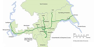
The Pennine Cycleway is a Sustrans-sponsored route in the Pennines range in northern England, an area often called the "backbone of England". The route passes through the counties of Derbyshire, West Yorkshire, Lancashire, North Yorkshire, Cumbria and Northumberland. It is part of the National Cycle Network (NCN). Sustrans founder John Grimshaw calls it 'the best National Cycle Network route of the lot'.

<span class="mw-page-title-main">National Cycle Route 1</span> Cycle route in the United Kingdom

National Cycle Route 1 is a route of the National Cycle Network, running from Dover to Tain. The 1,264 mi-long (2,034-kilometre) cycle-path is located in the United Kingdom.

National Cycle Network (NCN) Route 66 is a Sustrans National Route that runs from Kingston upon Hull to Manchester via Beverley, York and Leeds.

<span class="mw-page-title-main">Way of the Roses</span>

The Way of the Roses is the newest of Great Britain's coast-to-coast long-distance cycle routes and is based on minor roads, disused railway lines and specially constructed cycle paths. It lies entirely within the counties of Lancashire and Yorkshire, crossing the Yorkshire Dales and the Yorkshire Wolds in the North of England, passing through the historic cities of Lancaster, Ripon and York and scenic towns and villages including Settle and Pateley Bridge

<span class="mw-page-title-main">National Cycle Route 69</span> Cycle route in the United Kingdom

National Cycle Network (NCN) Route 69 is a Sustrans National Route that runs from Hest Bank to Cleethorpes. The route is incomplete and consists of one long section in Lancashire, and seven short sections in West Yorkshire. The open sections are signed in both directions.

<span class="mw-page-title-main">National Cycle Route 62</span> Long distance cycle route from Fleetwood to Selby, England

National Cycle Network (NCN) Route 62 is a Sustrans National Route that runs from Fleetwood to Selby. As of 2018 the route has a missing section between Preston and Southport but is otherwise open and signed.

The White Rose Cycle Route in Yorkshire, England, part of the National Cycle Network (NCN), was opened by Sustrans in 1998. It linked Middlesbrough with the City of Kingston upon Hull via the North York Moors, the Vale of York, the Yorkshire Wolds, a distance of 123 miles (198 km) and in some descriptions continued to Hornsea on the coast. A map and guide for the route were published in 1999 and 2000.

<span class="mw-page-title-main">National Cycle Route 658</span> Cycling route in York, England

National Cycle Network (NCN) Route 658 is a Sustrans Regional Route. It is two miles (3.2 km) long, and provides a connection between Route 65 and Route 66 through York city centre. The full length of the route is part of the Way of the Roses. It is fully signed and open.

<span class="mw-page-title-main">National Cycle Route 665</span> Cycle route in the United Kingdom

National Cycle Network (NCN) Route 665 is a Sustrans route from Wetherby to South West York. Two sections of the route are open. As of summer 2020 the route is not fully signed. The central section between Tadcaster and Newton Kyme is still a proposal.

National Cycle Network (NCN) Route 167 is a Sustrans regional route in the Yorkshire Wolds between Kirkham and Huggate. It is one of 5 NCN routes that make up the 146 mile Yorkshire Wolds Cycle Route. Created in 2011 it is fully open and signed.

<span class="mw-page-title-main">National Cycle Route 164</span> Cycle route in Yorkshire Wolds, England

National Cycle Network (NCN) Route 164 is a Sustrans regional route in the Yorkshire Wolds. The Northern section between Pocklington and Hutton Cranswick is part of the Way of the Roses, opened in 2010. The southern section links Beverley and Kiplingcotes via Newbold. Both sections are key parts of the 146 mile Yorkshire Wolds Cycle Route, opened in 2011. It is fully open and signed.

<span class="mw-page-title-main">National Cycle Route 656</span> Cycle route in Yorkshire, England

National Cycle Network (NCN) Route 656 is a Sustrans regional route in North Yorkshire. A 18.5 miles (29.8 km) cycle way between Coxwold and a junction with NCN Route 65 near Osmotherley via Sutton Bank National Park Centre and Hawnby. The route is fully opened and signed, it is on-road using quiet country lanes. Sustrans describe it as “a very strenuous route.”

National Cycle Network (NCN) Route 71 is a Sustrans National Route that runs from Whitehaven and Workington on the Cumbrian coast to Kirby Knowle in North Yorkshire to join NCN Route 65. The route is fully open and signed in both directions.

National Cycle Network (NCN) Route 70 is a Sustrans National Route that runs from Walney Island in Cumbria to Sunderland. The route is fully open and signed. From end to end the route is 149 miles (240 km), but two sections are shared with other NCN routes leaving Route 70 at 128 miles (206 km).

<span class="mw-page-title-main">National Cycle Route 688</span> Bikeway in North Yorkshire, England, connecting Winterburn and Linton-on-Ouse

National Cycle Network (NCN) Route 688 is a Sustrans National Route that runs from Winterburn to Linton-on-Ouse. It is 55 miles (89 km), fully open and signed.

<span class="mw-page-title-main">National Cycle Route 64</span> Long distance cycle route through the English East Midlands

National Cycle Network (NCN) Route 64 is a Sustrans National Route that runs from Market Harborough to Lincoln. The route is 68 miles (109 km) in length and is fully open and signed in both directions. There are three sections to the route, NCN 63 and NCN 15 form the links between these sections.

<span class="mw-page-title-main">National Cycle Route 67</span> Long distance cycle route running north-south through Yorkshire to the East Midlands.

National Cycle Network (NCN) Route 67 is a Sustrans National Route that runs from Long Whatton to Northallerton. The route is 124 miles (200 km) in length and is open but with sections missing.

References

  1. Peace, Richard (2000). The ultimate white rose cycle route guide. Wakefield: Excellent Books. ISBN   9781901464085.
  2. "Hull to Hornsea". GPS Cycle and Walking Routes. GPS Cycle and Walking Routes. Retrieved 27 July 2017.
  3. "Hull to Hornsea Slow Tour of Yorkshire" (PDF). Sustrans. Retrieved 31 July 2017.
  4. "Selby to Hessle". GPS Cycle and Walking Routes. GPS Cycle and Walking Routes. Retrieved 27 July 2017.
  5. "York to Selby". GPS Cycle and Walking Routes. Retrieved 27 July 2017.
  6. "York to Selby - Map | Sustrans". sustrans.org.uk. Retrieved 2 November 2016.
  7. "Cycle the Solar System". york.ac.uk. Retrieved 2 November 2016.
  8. "Way of the Roses". Sustrans. Retrieved 10 November 2016.
  9. "Scarborough Bridge project". www.york.gov.uk. Retrieved 21 April 2019.
  10. Council, City of York. "New Scarborough Bridge foot and cycle bridge to be lifted in by rail crane". www.york.gov.uk. Retrieved 21 April 2019.
  11. Peace, Richard (2000). The ultimate white rose cycle route guide. Wakefield: Excellent Books. pp. 68–71, 82–86. ISBN   9781901464085.
  12. "Route numbering system". Sustrans website. Sustrans . Retrieved 3 November 2016.
  13. "Millennium Mileposts". Sustrans. Retrieved 3 September 2017.
  14. "Trans Pennine Trail (East)". Sustrans. Retrieved 10 November 2016.