
The National Cycle Network (NCN) is the national cycling route network of the United Kingdom, which was established to encourage cycling and walking throughout Britain, as well as for the purposes of bicycle touring. It was created by the charity Sustrans who were aided by a £42.5 million National Lottery grant. However Sustrans themselves only own around 2% of the paths on the network, these rest being made of existing public highways and rights of way, and permissive paths negotiated by Sustrans with private landowners, which Sustrans have then labelled as part of their network.
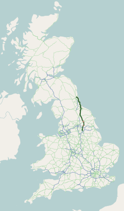
The A19 is a major road in England running approximately parallel to and east of the A1 road. Although the two roads meet at the northern end of the A19, the two roads originally met at the southern end of the A19 in Doncaster, but the old route of the A1 was changed to the A638. From Sunderland northwards, the route was formerly the A108. In the past the route was known as the East of Snaith-York-Thirsk-Stockton-on-Tees-Sunderland Trunk Road. Most traffic joins the A19, heading for Teesside, from the A168 at Dishforth Interchange.
The Coast to Coast or Sea to Sea Cycle Route (C2C) is a 140 miles (230 km) cycle route opened in 1994. Combining sections of National Cycle Route 7, 14, 71 and 72; it runs from Whitehaven or Workington on the west coast of Cumbria, and then crosses the Lake District and the Pennines in the north of England by using a variety of both on and off-road trails, ending on the north-east coast in Tyne and Wear at Sunderland or Tynemouth. Sustrans state that it is the UK's most popular challenge cycle route, it is designed for the whole range of cyclists, from families to cycling club riders. Although a challenge with some hard climbs—the highest point being over 609 m (1,998 ft)—the C2C is completed by an average of between 12,800 and 15,000 cyclists every year.
The Walney to Wear and Whitby Cycle Route is the name of a cross-country cycle route in Northern England. It runs from Walney Island in Cumbria to Sunderland on the River Wear or Whitby.

Upsall is a hamlet in and civil parish in the Hambleton district of North Yorkshire, England. It is situated approximately four miles north-east of Thirsk. Upsall is part of the Upsall and Roxby estates owned by the Turton family. The population of the civil parish was estimated at 60 in 2014.

National Cycle Route 1 is a route of the National Cycle Network, running from Dover to Tain. The 1,264 mi-long (2,034-kilometre) cycle-path is located in the United Kingdom.

The Way of the Roses is the newest of Great Britain's coast-to-coast, long-distance cycle routes and is based on minor roads, disused railway lines and specially constructed cycle paths. It lies entirely within the counties of Lancashire and Yorkshire, crossing the Yorkshire Dales and the Yorkshire Wolds in the north of England, passing through the historic cities of Lancaster and York and scenic towns and villages including Settle, Pateley Bridge and Ripon.
National Cycle Route 63 is a route of the National Cycle Network, running from Burton on Trent to Wisbech.

National Cycle Network (NCN) Route 69 is a Sustrans National Route that runs from Hest Bank to Cleethorpes. The route is incomplete and consists of one long section in Lancashire, and seven short sections in West Yorkshire. The open sections are signed in both directions.
The White Rose Cycle Route in Yorkshire, England, part of the National Cycle Network (NCN), was opened by Sustrans in 1998. It linked Middlesbrough with the City of Kingston upon Hull via the North York Moors, the Vale of York, the Yorkshire Wolds, a distance of 123 miles (198 km) and in some descriptions continued to Hornsea on the coast. A map and guide for the route were published in 1999 and 2000.

National Cycle Network (NCN) Route 65 is a Sustrans National Route that runs from Hornsea on the North Sea Coast of The East Riding of Yorkshire via Hull and York to Middlesbrough. It is fully open and signed.

National Cycle Network (NCN) Route 658 is a Sustrans Regional Route. It is two miles (3.2 km) long, and provides a connection between Route 65 and Route 66 through York city centre. The full length of the route is part of the Way of the Roses. It is fully signed and open.

National Cycle Network (NCN) Route 665 is a Sustrans route from Wetherby to South West York. Two sections of the route are open. As of summer 2020 the route is not fully signed. The central section between Tadcaster and Newton Kyme is still a proposal.
National Cycle Network (NCN) Route 167 is a Sustrans regional route in the Yorkshire Wolds between Kirkham and Huggate. It is one of 5 NCN routes that make up the 146 mile Yorkshire Wolds Cycle Route. Created in 2011 it is fully open and signed.

National Cycle Network (NCN) Route 164 is a Sustrans regional route in the Yorkshire Wolds. The Northern section between Pocklington and Hutton Cranswick is part of the Way of the Roses, opened in 2010. The southern section links Beverley and Kiplingcotes via Newbold. Both sections are key parts of the 146 mile Yorkshire Wolds Cycle Route, opened in 2011. It is fully open and signed.

National Cycle Network (NCN) Route 166 is a Sustrans regional route in the Yorkshire Wolds between Kirkham and Hunmanby. It is one of 5 NCN routes that make up the 146 mile Yorkshire Wolds Cycle Route. Created in 2011 it is fully open and signed.
National Cycle Network (NCN) Route 656 is a Sustrans regional route in North Yorkshire. A 18.5 miles (29.8 km) cycle way between Coxwold and a junction with NCN Route 65 near Osmotherley via Sutton Bank National Park Centre and Hawnby. The route is fully opened and signed, it is on-road using quiet country lanes. Sustrans describe it as “a very strenuous route.”
National Cycle Network (NCN) Route 71 is a Sustrans National Route that runs from Whitehaven and Workington on the Cumbrian coast to Kirby Knowle in North Yorkshire to join NCN Route 65. The route is fully open and signed in both directions.
National Cycle Network (NCN) Route 70 is a Sustrans National Route that runs from Walney Island in Cumbria to Sunderland. The route is fully open and signed. From end to end the route is 149 miles (240 km), but two sections are shared with other NCN routes leaving Route 70 at 128 miles (206 km).

