Huntingdon

Last updated

Huntingdon
Market town
Cmglee Huntingdon town hall war memorial.jpg
Huntingdon Town Hall and The Thinking Soldier War Memorial
Cambridgeshire UK location map.svg
Red pog.svg
Huntingdon
Location within Cambridgeshire
Population25,428 (2021 Census) [1]
OS grid reference TL245725
District
Shire county
Region
Country England
Sovereign state United Kingdom
Areas of the town
List
  • Hartford
  • Sapley
  • Stukeley Meadows
  • Town Centre
Post town HUNTINGDON
Postcode district PE28, PE29
Dialling code 01480
Police Cambridgeshire
Fire Cambridgeshire
Ambulance East of England
UK Parliament
List of places
UK
England
Cambridgeshire
52°20′11″N0°10′18″W / 52.3364°N 0.1717°W / 52.3364; -0.1717

Huntingdon is a market town in the Huntingdonshire district of Cambridgeshire, England. The town was given its town charter by King John in 1205. It was the county town of the historic county of Huntingdonshire. Oliver Cromwell was born there in 1599 [2] and became one of its Members of Parliament (MP) in 1628. The former Conservative Prime Minister (1990–1997) John Major served as its MP from 1979 until his retirement in 2001.

Contents

History

During the Roman Empire, in 274, a massive coin hoard dating to the reign of Tetricus I and Roman Emperor Aurelian was hidden in the grounds of the town. Consisting of 9724 Roman coins, and discovered in 2018, the Muddy Hoard is considered to date the largest treasure trove of Cambridgeshire. [3] [4]

Huntingdon was founded by the Anglo-Saxons and Danes. It is first mentioned in the Anglo-Saxon Chronicle in 921, where it appears as Huntandun. It appears as Huntedun in the Domesday Book of 1086. The name means "The huntsman's hill" or possibly "Hunta's hill". [5]

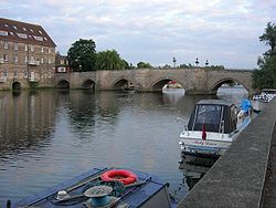
Huntingdon seems to have been a staging post for Danish raids outside East Anglia until 917, when the Danes moved to Tempsford, now in Bedfordshire, before they were crushed by Edward the Elder. It prospered successively as a bridging point of the River Great Ouse, a market town, and in the 18th and 19th centuries a coaching centre, notably at the George Hotel. The town has a well-preserved medieval bridge that used to serve as the main route of Ermine Street over the river. The bridge only ceased to be the sole crossing point to Godmanchester in 1975, with the building of what is now the A1307 (formerly A14) bypass.

Sebastopol cannon Sebastopol cannon Huntingdon uk.jpg
Sebastopol cannon

The town's valuable trading position was secured by Huntingdon Castle, of which only the earthworks of the motte survive. The site is a Scheduled Ancient Monument and home to a beacon used to mark the 400th anniversary of the Spanish Armada.

In 1746, the nurserymen Wood and Ingram of nearby Brampton developed an elm-tree cultivar, Ulmus × hollandica 'Vegeta' , which they named the Huntingdon Elm after the town. [6]

Original documents on Huntingdon's history, including the borough charter of 1205, are held by Cambridgeshire Archives and Local Studies at the County Record Office, Huntingdon. [7]

Parts of Huntingdon, including the centre, were struck by an F1/T3 tornado on 23 November 1981, during a record-breaking nationwide tornado outbreak on that day. [8] The centre suffered moderate damage.

Between the railway station and the old hospital building, stands a replica cannon installed in the 1990s to replace one from the Crimean War, scrapped for the war effort in the Second World War. However, it faces in the opposite direction from the original. St Mary's Street drill hall was built in the late 19th century. [9]

George Hotel

The George Hotel on the corner of High Street and George Street was once a posting house. It was named after Saint George of England in 1574 and bought some 25 years later by Henry Cromwell, grandfather of Oliver Cromwell. [2] Charles I made the George his headquarters in 1645. Later the highwayman Dick Turpin is said to have been a customer when it was a coaching inn on the Great North Road. A theatre was built to the rear of the George in about 1799. The Lincoln company of actors managed by Thomas Shaftoe Robertson and later Fanny Robertson performed here in race weeks. [10] Two wings of the inn burnt down in the mid-19th century, but two were saved, including one with a balcony overlooking the yard. Since 1959, the courtyard and balcony have been used for Shakespeare performances by a company run by the Shakespeare at the George Trust. [11]

Government

Huntingdon welcome sign UK Huntingdon.jpg
Huntingdon welcome sign

Huntingdon has a town council with 19 councillors elected every four years. [12] Two of them serve also as mayor and deputy mayor. [13] Meetings are normally held once a month at Huntingdon Town Hall. [14]

Huntingdonshire District Council has three wards: Huntingdon North, Huntingdon East and Huntingdon West. [15] The three wards each have two councillors. [16] The main offices of Huntingdonshire District Council are in Huntingdon itself.

The third tier of local-government is Cambridgeshire County Council providing county-wide services such as roads, education, social services, libraries and heritage protection. [17] Huntingdon is one of 60 electoral divisions, [15] represented by two county councillors. [18]

The fourth tier of local government is Cambridgeshire and Peterborough Combined Authority, which is headed by a mayor. The Authority's website states that "the Mayor of Cambridgeshire & Peterborough is Dr Nik Johnson. [19]

Huntingdon lies in the parliamentary constituency of Huntingdon.

Geography

The town lies on the north bank of the River Great Ouse opposite Godmanchester and close to the market town of St Ives to the east and the village of Brampton to the west. Huntingdon incorporates the village of Hartford to the east and the developing areas of Oxmoor, Stukeley Meadows and Hinchingbrooke to the north and west.

Between Godmanchester, Huntingdon and Brampton lies Portholme Meadow, England's largest. [20] Its 257 acres (104 hectares) contain many rare species of grass, flowers and dragonfly. It is the only known British habitat of the marsh dandelion. It acts as a natural reservoir for water in times of flood, enabling the river to run off slowly, so helping to preclude flooding in nearby towns. It has also served as a horse racecourse and once was a centre for aviation.

Business

Huntingdon is home to many local businesses, including Huntingdon Racecourse. Hinchingbrooke Business Park also contains offices and warehouses.

Climate

The nearest weather station for long-term data is at RAF Wyton, 3 mi (5 km) north-east of the town centre. More recently Monks Wood, 5 mi (8 km) to the north-west, has also provided data.

Like most of Britain, Huntingdon has a temperate, maritime climate free of temperature extremes, with rainfall spread fairly evenly over the year. The absolute maximum recorded at Wyton was 35.4 °C (95.7 °F) [21] in August 1990; the temperature at Monks Wood rose in July 2006 to 35.1 °C (95.2 °F). [22] The mean annual warmest day is 29.7 °C (85.5 °F), [23] and on 16 days a year will rise to 25.1 °C (77.2 °F) or above. [24]

Typically 43.2 nights of the year report an air frost. [25] The absolute minimum at Wyton was −16.1 °C (3.0 °F) [26] in January 1982. The mean for the annual coldest night of the year is −7.7 °C (18.1 °F). [27]

With annual rainfall at under 550 millimetres (21+12 inches) a year, [28] the Huntingdon area is among the driest in the UK – 103.4 days on average record at least 1 mm of rain. [29] All averages mentioned refer to the period 1971–2000.

Demography

Population

Between 1801 and 1901, the current area of Huntingdon consisted of four parishes: Huntingdon All Saints, Huntingdon St Benedict, Huntingdon St John and Huntingdon St Mary. The populations of these were counted in the ten-year UK census and ranged in the period between 2,368 in 1801 and 4,735 in 1891. [30] (The census was omitted in 1941.)

Parish
1911
1921
1931
1951
1961
1971
1981
1991
2001
2011
Huntingdon4,4644,6444,5705,28214,64815,45120,09923,732

All population census figures are taken from the report Historic Census figures Cambridgeshire to 2011 by Cambridgeshire Insight. [30] For the censuses of 1961 and 1971, Huntingdon was combined with Godmanchester.

In 2011, the parish covered an area of 2,765 acres (1,119 hectares). [30] The population density in that year was 5,493.1 inhabitants per square mile (2,120.9 inhabitants per square kilometre).

Culture and community

The former Literary and Scientific Institute is now Commemoration Hall.

The Old Bridge across the Great Ouse, to Godmanchester. Huntingdon Old Bridge.jpg
The Old Bridge across the Great Ouse, to Godmanchester.

Following the 2013 closure of RAF Brampton, once home to Headquarters RAF Support Command, there are now two operational RAF stations within 4 mi (6 km) of the town: RAF Wyton, once a major flying station but now a facility of the Defence Equipment and Support arm of the MOD and RAF Alconbury currently occupied by the United States Air Force.

Part of the medieval infirmary hall of St Johns in the market place became Huntingdon Grammar School. It was attended by Cromwell and by the diarist Samuel Pepys. The building is now the Cromwell Museum, run by Cambridgeshire County Council.

Interior of the Cromwell Museum Cmglee Huntingdon Cromwell Museum.jpg
Interior of the Cromwell Museum

Legends

Hinchingbrooke House, once a convent, is said to be haunted. The bridge over the Alconbury Brook named Nun's Bridge is said also to be haunted, by one of the nuns who once lived at the convent. [31] She is said often to be accompanied by another ghost that resembles a nurse. The myth goes that the nun had a monk-lover who caused them to be murdered.

Media

Local news and television programmes are provided by BBC East and ITV Anglia. Television signals are received from the Sandy Heath TV transmitter. [32]

Local radio stations are BBC Radio Cambridgeshire, Heart East,Greatest Hits Radio East, Star Radio and HCR FM, a community based station that broadcast from the town. [33]

The Hunts Post is the town's local weekly newspaper. [34]

Education

The local primary schools are Hartford Junior School, Huntingdon Primary School, Thongsley Fields Primary School, St John's Primary School, Stukeley Meadows Primary School and Cromwell Academy Primary School. Spring Common School is a special-needs school. Secondary schools include St Peter's School and Hinchingbrooke School. Further education colleges include Huntingdonshire Regional College, Hinchingbrooke School sixth-form college and St Peter's sixth form.

Transport

Railway

Huntingdon station Huntingdon Station - geograph.org.uk - 1018223.jpg
Huntingdon station

Huntingdon railway station is sited on the East Coast Main Line. Services that stop here are operated by Govia Thameslink Railway, on the Thameslink and Great Northern routes.

Great Northern services operate between Peterborough and London Kings Cross station; trains take just over an hour to reach the capital. Thameslink services run between Peterborough and Horsham, in West Sussex, via St Pancras and Blackfriars. [35]

Buses

Bus services are operated primarily by Stagecoach East and Whippet. Routes serve the town, including Hinchingbrooke Hospital, and connect Huntingdon with Peterborough, St Neots, Ramsey, St Ives and Cambridge. [36]

Air

Luton and Stansted airports are located within 40 miles (64 km) of the town.

Religious sites

All Saints' Church, from Market Square HuntingdonTown-18.jpg
All Saints' Church, from Market Square

There are four Church of England churches in Huntingdon, once there were more, which together with those in the adjacent villages Great and Little Stukeley are members of the Huntingdon Team Ministry [37] in the Diocese of Ely. The four are All Saints' (next to the Market Square), St Mary's (opposite Pathfinder House), St Barnabas (on the Oxmoor estate) and All Saints', Hartford.

Huntingdon Methodist Church is in the High Street. [38] Medway Christian Fellowship is based on Medway Road. [39]

Sport

The highest-ranking football club, Huntingdon Town, plays in the United Counties League. Huntingdon United RGE plays in the Cambridgeshire League.

Notable residents

Terry Reid in 1974 Terry Reid.jpg
Terry Reid in 1974

Names are in birth order. Data are from the subject's Wikipedia article except where referenced.

Arts and entertainment

Literature

Portrait of Samuel Pepys, by John Hayls, 1666 Samuel Pepys.jpg
Portrait of Samuel Pepys, by John Hayls, 1666

Religion

Politics

Oliver Cromwell, 1646 Oliver Cromwell by Samuel Cooper.jpg
Oliver Cromwell, 1646

Science and engineering

Sports

Darren Bent in 2008 Darren Bent 26-04-2008 1.jpg
Darren Bent in 2008

International relations

Twin towns

Source: [50]

Freedom of the Town

The following people and military units have received the Freedom of the Town of Huntingdon.

Individuals

Military Units

See also

Related Research Articles

<span class="mw-page-title-main">Cambridgeshire</span> County of England

Cambridgeshire is a ceremonial county in the East of England and East Anglia. It is bordered by Lincolnshire to the north, Norfolk to the north-east, Suffolk to the east, Essex and Hertfordshire to the south, and Bedfordshire and Northamptonshire to the west. The largest settlement is the city of Peterborough, and the city of Cambridge is the county town.

<span class="mw-page-title-main">Huntingdonshire</span> Historic county and district of Cambridgeshire, England

Huntingdonshire is a local government district in Cambridgeshire, England. It was historically a county in its own right. It borders Peterborough to the north, Fenland to the north-east, East Cambridgeshire to the east, South Cambridgeshire to the south-east, Central Bedfordshire and Bedford to the south-west, and North Northamptonshire to the west.

<span class="mw-page-title-main">Ramsey Abbey</span> English Benedictine abbey, now ruins

Ramsey Abbey was a Benedictine abbey in Ramsey, Huntingdonshire, England. It was founded about AD 969 and dissolved in 1539.

<span class="mw-page-title-main">Perry, Cambridgeshire</span> Human settlement in England

Perry is a village and civil parish in Cambridgeshire, England, approximately 6 miles (10 km) south-west of Huntingdon. Perry is in Huntingdonshire, a non-metropolitan district of Cambridgeshire and historic county of England. Perry is on the shore of a reservoir, Grafham Water, a few miles from the market town of St Neots.

<span class="mw-page-title-main">Godmanchester</span> Human settlement in England

Godmanchester is a town and civil parish in the Huntingdonshire district of Cambridgeshire, England. It is separated from Huntingdon, 1 mile (1.6 km) to the north, by the valley of the River Great Ouse. Being on the Roman road network, the town has a long history. It has a waterside location, surrounded by open countryside of high value for its biodiversity but it remains highly accessible, with a railway line to London, the A1 road and M11/A14 which run nearby.

<span class="mw-page-title-main">Ramsey, Cambridgeshire</span> Human settlement in England

Ramsey is a market town and civil parish in the Huntingdonshire district of Cambridgeshire, England. The town is about 9 miles (14 km) north of Huntingdon. Ramsey parish includes the settlements of Ramsey Forty Foot, Ramsey Heights, Ramsey Mereside, Ramsey Hollow and Ramsey St Mary's.

<span class="mw-page-title-main">Yaxley, Cambridgeshire</span> Human settlement in England

Yaxley is a village and civil parish in the Huntingdonshire district in Cambridgeshire, England. Yaxley lies approximately 4 miles (6 km) south of Peterborough, just off the A15 road. The village is located near the Hampton township, and is approximately three miles northeast of junction 16 of the A1(M) at Norman Cross.

<span class="mw-page-title-main">Huntingdon (UK Parliament constituency)</span> Parliamentary constituency in the United Kingdom, 1801-1918 & 1983 onwards

Huntingdon is a constituency west of Cambridge in Cambridgeshire and including its namesake town of Huntingdon. It has been represented in the House of Commons of the UK Parliament since 2001 by Jonathan Djanogly of the Conservative Party.

<span class="mw-page-title-main">Alconbury</span> Human settlement in England

Alconbury is a village and civil parish in Cambridgeshire, England. Alconbury is situated within Huntingdonshire which is a non-metropolitan district of Cambridgeshire as well as being an historic county of England. Alconbury lies approximately 5 miles (8 km) north-west of Huntingdon.

<span class="mw-page-title-main">Houghton, Cambridgeshire</span> Human settlement in England

Houghton is a village and former civil parish, now in the parish of Houghton and Wyton, in Cambridgeshire, England, approximately 3 miles (5 km) east of Huntingdon on the A1123 road, and south of RAF Wyton. It lies on the north bank of the River Great Ouse, by Houghton Mill.

Brampton is a village and civil parish in Cambridgeshire, England, about 2 miles (3 km) south-west of Huntingdon. It lies within Huntingdonshire, a non-metropolitan district of Cambridgeshire and a historic county of England. According to the 2011 UK census Brampton had a population of 4,862 A 2019 estimate puts it at 5,462.

<span class="mw-page-title-main">Tetworth</span> Human settlement in England

Tetworth is a village and former civil parish, now in the parish of Waresley-cum-Tetworth, in Cambridgeshire, England. Tetworth lies approximately 12 miles (19 km)south of Huntingdon, near Waresley south of St Neots. Tetworth is situated within Huntingdonshire which is a non-metropolitan district of Cambridgeshire as well as being a historic county of United Kingdom. In 2001 the parish had a population of 45.

<span class="mw-page-title-main">Great Gidding</span> Human settlement in England

Great Gidding is a village and civil parish in the Huntingdonshire district of Cambridgeshire, England.

<span class="mw-page-title-main">Wyton, Cambridgeshire</span> Human settlement in England

Wyton is a village and former civil parish, now in the parish of Houghton and Wyton, in Cambridgeshire, England. It lies approximately 2 miles (3 km) east of Huntingdon. Wyton is connected to the village of Houghton, so much so that the two settlements are rarely regarded as separate. Wyton is situated within Huntingdonshire, a non-metropolitan district of Cambridgeshire as well as being a historic county of England. In 1931 the parish had a population of 445.

<span class="mw-page-title-main">Huntingdonshire District Council</span>

Huntingdonshire District Council is the local authority for the district of Huntingdonshire in Cambridgeshire, England. The council is based in the town of Huntingdon. The district also includes the towns of Godmanchester, Ramsey, St Ives and St Neots and surrounding rural areas. The district covers almost the same area as the historic county of Huntingdonshire, which had been abolished for administrative purposes in 1965, with some differences to the northern boundary with Peterborough.

<span class="mw-page-title-main">Wyton on the Hill</span> Human settlement in England

Wyton on the Hill is a village and civil parish in Cambridgeshire, England. Wyton on the Hill lies approximately 3 miles (5 km) north-east of Huntingdon and 1 mile (2 km) north of Houghton. Wyton on the Hill is situated within Huntingdonshire which is a non-metropolitan district of Cambridgeshire as well as being a historic county of England. The parish centres on RAF Wyton and the majority of its residents are servicemen and their families.

<span class="mw-page-title-main">Sir Oliver Cromwell</span>

Sir Oliver Cromwell was an English landowner, lawyer and politician who sat in the House of Commons at various times between 1589 and 1625. He was the uncle of Oliver Cromwell, the Member of Parliament, general, and Lord Protector of England.

References

  1. "Huntingdon". City population. Retrieved 25 October 2022.
  2. 1 2 3 "Cromwell, Oliver"  . Encyclopædia Britannica . Vol. 7 (11th ed.). 1911. pp. 487–498.
  3. "Detectorist finds 10,000 Roman coins in Huntingdon hoard". BBC News. 19 December 2021. Retrieved 22 September 2023.
  4. Museum, The British; Street, Great Russell; T: +4420 73238618, London WC1B 3DG. "Record ID: CAM-A0ECFB - ROMAN hoard". The Portable Antiquities Scheme. Retrieved 22 September 2023.{{cite web}}: CS1 maint: numeric names: authors list (link)
  5. Eilert Ekwall, The Concise Oxford Dictionary of English Place-names, p. 258.
  6. Louis John Drake, Wood and Ingram: A Huntingdonshire Nursery 1742-1950.
  7. "Archived copy". Archived from the original on 23 December 2008. Retrieved 30 March 2009.{{cite web}}: CS1 maint: archived copy as title (link)cambridgeshire.gov.uk
  8. "European Severe Weather Database".
  9. "The Huntingdonshire Cyclist Battalions 1914–1919". Porch Museum. Retrieved 20 September 2017.
  10. Neil R Wright (2016). Treading the Boards. SLHA. p. 141.
  11. "Shakespeare at the George". www.satg.org.uk. Retrieved 19 November 2017.
  12. "Huntingdon Town Council: Councillors". www.huntingdontown.gov.uk. Huntingdon Town Council. Retrieved 8 February 2016.
  13. "Huntingdon Town Council: Mayor of Huntingdon". www.huntingdontown.gov.uk. Huntingdon Town Council. Retrieved 8 February 2016.
  14. "Huntingdon Town Council: council meetings". www.huntingdontown.gov.uk. Huntingdon Town Council. Retrieved 8 February 2016.
  15. 1 2 "Ordnance Survey Election Maps". www.ordnancesurvey.co.uk. Ordnance Survey. Retrieved 4 February 2016.
  16. "Huntingdonshire District Council: Councillors". www.huntsdc.gov.uk. Huntingdonshire District Council. Retrieved 4 February 2016.
  17. "Cambridgeshire County Council". www.cambridgeshire.gov.uk. Cambridgeshire County Council. Retrieved 23 February 2016.
  18. "Cambridgeshire County Council: Councillors". www.cambridgeshire.gov.uk. Cambridgeshire County Council. Archived from the original on 22 February 2016. Retrieved 15 February 2016.
  19. "Cambridgeshire & Peterborough Combined Authority". Cambridgeshire & Peterborough Combined Authority. Retrieved 10 July 2023.
  20. http://www.huntingdon-town.info/portholme.htm huntingdon-town.info
  21. "> 1990 Maximum" . Retrieved 25 February 2011.
  22. "> July 2006". Archived from the original on 29 June 2011. Retrieved 25 February 2011.
  23. "> The mean annual warmest day" . Retrieved 25 February 2011.
  24. ">25c days" . Retrieved 25 February 2011.
  25. "air frost incidence" . Retrieved 25 February 2011.
  26. "1982 minimum" . Retrieved 25 February 2011.
  27. "Mean annual coldest night" . Retrieved 25 February 2011.
  28. "Annual average rainfall". Archived from the original on 24 July 2011. Retrieved 25 February 2011.
  29. "Annual average wetdays". Archived from the original on 24 July 2011. Retrieved 25 February 2011.
  30. 1 2 3 "Historic Census figures Cambridgeshire to 2011". www.cambridgeshireinsight.org.uk. Cambridgeshire Insight. Archived from the original (xlsx – download) on 15 February 2016. Retrieved 12 February 2016.
  31. http://www.francisfrith.com/huntingdon/photos/nuns-bridge-1901_46623/ francisfrith.com
  32. "Full Freeview on the Sandy Heath (Central Bedfordshire, England) transmitter". UK Free TV. 1 May 2004. Retrieved 22 November 2023.
  33. "Huntingdon Community Radio" . Retrieved 22 November 2023.
  34. "The Hunts Post". British Papers. 12 March 2014. Retrieved 22 November 2023.
  35. "Timetables". Thameslink. 21 May 2023. Retrieved 10 June 2023.
  36. "Stops in Huntingdon". Bus Times. 2023. Retrieved 10 June 2023.
  37. http://www.huntingdonanglicanchurches.org.uk huntingdonanglicanchurches.org.uk
  38. "Home". Huntingdon Methodist Church. Retrieved 19 November 2017.
  39. "Medway Christian Fellowship – Love Oxmoor – A church in the heart of the community". loveoxmoor.org.uk. Retrieved 19 November 2017.
  40. Davis, Henry William Carless (1911). "Henry of Huntingdon"  . Encyclopædia Britannica . Vol. 13 (11th ed.). p. 298.
  41. Hannay, David McDowall (1911). "Pepys, Samuel"  . Encyclopædia Britannica . Vol. 21 (11th ed.). pp. 130–132.
  42. "Sandwich, John Montagu, 4th Earl of"  . Encyclopædia Britannica . Vol. 24 (11th ed.). 1911. pp. 142–143.
  43. Rootsweb Retrieved 11 March 2016.
  44. BCW Project Retrieved 12 March 2016.
  45. Yorke, Philip Chesney (1911). "Cromwell, Richard"  . Encyclopædia Britannica . Vol. 7 (11th ed.). pp. 498–499.
  46. "Cromwell, Henry"  . Encyclopædia Britannica . Vol. 7 (11th ed.). 1911. pp. 486–487.
  47. "Charlie Elphicke trial: Ex-MP guilty of sexual assaults". BBC News. 30 July 2020. Retrieved 10 July 2023.
  48. "Foster, Sir Michael"  . Encyclopædia Britannica . Vol. 10 (11th ed.). 1911. p. 733.
  49. Chelsea info Retrieved 8 January 2016.
  50. "Huntingdon and Godmanchester's Twin Towns". Huntingdon Town Council. 15 June 2015. Retrieved 8 May 2021.
  51. Gilham, Aexander (27 May 2022). "Great honour for two men awarded the freedom of Huntingdon". The Hunts Post. Retrieved 19 June 2022.
  52. Collett, Alexandra (17 September 2020). "Wreath-laying ceremony in Huntingdon for Battle of Britain anniversary". www.huntspost.co.uk.
  53. "Copy of the Charter awarding the freedom of the Borough of Huntingdon to RAF Wyton". Cambridgeshire Community Archive Network. Retrieved 4 November 2021.
  54. "Huntingdon to host RAF parade today". www.huntspost.co.uk. 12 April 2011.
  55. "Archived copy". Archived from the original on 3 March 2017. Retrieved 15 May 2017.{{cite web}}: CS1 maint: archived copy as title (link)
  56. "US Air Force unit gets freedom of town". BBC News.
  57. Ridley, Katie (21 September 2018). "Combat Support Wing awarded freedom of Huntingdon".