
The River Waveney is a river which forms the boundary between Suffolk and Norfolk, England, for much of its length within The Broads. The "ey" part of the name means "river" thus the name is tautological.

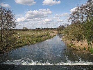
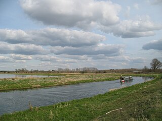
The River Great Ouse is a river in England, the longest of several British rivers called "Ouse". From Syresham in Northamptonshire, the Great Ouse flows through Buckinghamshire, Bedfordshire, Cambridgeshire and Norfolk to drain into the Wash and the North Sea near Kings Lynn. With a course of about 143 miles (230 km), mostly flowing north and east, it is the fifth longest river in the United Kingdom. The Great Ouse has been historically important for commercial navigation, and for draining the low-lying region through which it flows; its best-known tributary is the Cam, which runs through Cambridge. Its lower course passes through drained wetlands and fens and has been extensively modified, or channelised, to relieve flooding and provide a better route for barge traffic. The unmodified river would have changed course regularly after floods.
The River Lark is a river in England that crosses the border between Suffolk and Cambridgeshire. It is a tributary of the River Great Ouse, and was extended when that river was re-routed as part of drainage improvements. It is thought to have been used for navigation since Roman times, and improvements to its navigability were made in 1638 and in the early 18th century, when locks and staunches were built. The upper terminus was on the northern edge of Bury St Edmunds, but a new dock was opened near the railway station after the Eastern Union Railway opened its line in 1846.
The River Little Ouse is a river in the east of England, a tributary of the River Great Ouse. For much of its length it defines the boundary between Norfolk and Suffolk.

St Neots is a town in the Huntingdonshire District of the county of Cambridgeshire, England. It lies about 50 miles (80 km) north of London and about 18 miles (29 km) west of Cambridge. The districts of Eynesbury, Eaton Ford and Eaton Socon were formerly independent but nowadays are considered merged into St Neots.
Eaton Ford is an area of St Neots, Cambridgeshire, England, approximately 81 km (50 mi) north of London. Historically in Bedfordshire, it was transferred to Huntingdonshire in 1965, before becoming part of Cambridgeshire in 1974.
Kimbolton is a village and civil parish in England. Kimbolton is about 9 miles (14 km) west of Huntingdon and 14 miles (23 km) north of Bedford. Kimbolton is administered as part of Cambridgeshire; however it is situated within Huntingdonshire, which is an historic county of England and is now a non-metropolitan district of Cambridgeshire. The parish includes the hamlet of Stonely.

Little Barford is a hamlet and civil parish in the Borough of Bedford in Bedfordshire, England about 7 miles (11 km) northeast of the county town of Bedford.

The River Ivel is a north-flowing river in the western part of east of England. It is primarily in Bedfordshire; it is a tributary of the River Great Ouse and has sources including in the Barton Hills.

Great Barford is a village and civil parish in Bedfordshire, England, a few miles north-east of Bedford. It lies on the River Great Ouse at grid reference TL129523. It is twinned with Wöllstein, Germany. The village is bypassed by the busy A421 road on the way between Bedford and St Neots in Cambridgeshire, the bypass opening on 24 August 2006.

Little Paxton in Cambridgeshire, England is a village and civil parish that lies 5 miles (8.0 km) south of Huntingdon and 1.7 miles (2.7 km) north of St Neots. It is in the district and historic county of Huntingdonshire. Until the 1970s it was a minor village and the church was under threat of closure. The building of a housing estate and a junior school revived its fortunes and the establishment of the Paxton Pits Nature Reserve around part of the nearby gravel pits has brought visitors to the village.

Tilbrook is a village and civil parish in Cambridgeshire, England. Tilbrook lies approximately 10 miles (16 km) west of Huntingdon, near Covington. Tilbrook is situated within Huntingdonshire which is a non-metropolitan district of Cambridgeshire as well as being a historic county of England, although Tilbrook belongs historically to Bedfordshire.

Hail Weston is a village and civil parish in Cambridgeshire, England. Hail Weston lies approximately 7 miles (11 km) south of Huntingdon. Hail Weston is situated within Huntingdonshire which is a non-metropolitan district of Cambridgeshire as well as being a historic county of England.

Blunham is a village and civil parish in the Central Bedfordshire district of Bedfordshire, England, about 8 miles (13 km) east of Bedford. At the 2011 census date its population was 946. The River Ivel forms the parish's eastern boundary in places and the River Great Ouse its western and northern boundaries. The village is just over 0.6 miles (1 km) to the west of the A1 road, and Route 51 of the National Cycle Network passes to the south.
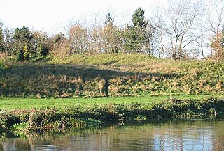
Eaton Socon Castle stood beside the River Ouse in the village of Eaton Socon, which was originally a village in Bedfordshire but is now a district of St Neots in Cambridgeshire.

Tempsford is a village and civil parish in the Central Bedfordshire district of the county of Bedfordshire, England, about 7 miles (11 km) east north-east of the county town of Bedford.

Begwary Brook in Bedfordshire is a four mile long tributary of the River Great Ouse. Its source is half a mile north of Duck's Cross, and it then flows east to join the Great Ouse in Wyboston. The Environment Agency classes its water quality as good.
Roxton is a small village and civil parish in the Borough of Bedford, Bedfordshire, England about 7 miles (11 km) north-east of the county town of Bedford.

Little Staughton is a small village and civil parish located in the north of Bedfordshire. The parish church, All Saints, is set apart from the present village – the previous village having been abandoned following an outbreak of the Bubonic plague.

