Littleport

Last updated • 6 min readFrom Wikipedia, The Free Encyclopedia

Littleport
St George's Church, Littleport - geograph.org.uk - 112543.jpg
St George's Church
Cambridgeshire UK location map.svg
Red pog.svg
Littleport
Location within Cambridgeshire
Area2.417 km2 (0.933 sq mi)  [1]
Population9,168 (2021) [2]
  Density 3,793/km2 (9,820/sq mi)
OS grid reference TL568868
  London 67.4 mi (108.5 km)  S
District
Shire county
Region
Country England
Sovereign state United Kingdom
Post town ELY
Postcode district CB6
Dialling code 01353
Police Cambridgeshire
Fire Cambridgeshire
Ambulance East of England
UK Parliament
List of places
UK
England
Cambridgeshire
52°27′24″N0°18′17″E / 52.4568°N 0.3046°E / 52.4568; 0.3046

Littleport is a village in East Cambridgeshire, in the Isle of Ely, Cambridgeshire, England. [3] It lies about 6 miles (10 km) north-east of Ely and 6 miles (10 km) south-east of Welney, on the Bedford Level South section of the River Great Ouse, close to Burnt Fen and Mare Fen. There are two primary schools, Millfield Primary and Littleport Community, and a secondary, Vista Academy. The Littleport riots of 1816 influenced the passage of the Vagrancy Act 1824.

Contents

History

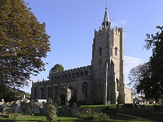
With an Old English name of Litelport, the village was worth 17,000 eels a year to the Abbots of Ely in 1086. [4]

The legendary founder of Littleport was King Canute. A fisherman gave the king shelter one night, after drunken monks had denied him hospitality. After punishing the monks, he made his host the mayor of a newly founded village. [5]

The Littleport Riots of 1816 broke out after war veterans from the Battle of Waterloo returned home, only to find they could get no work and grain prices had gone up. They took to the streets and smashed shops and buildings until troops were brought in. [6] St George's church registers were destroyed in the riots. [7] The remaining registers start from 1754 (marriages), 1756 (burials), and 1783 (baptisms). Some original documents to do with the riots are held in Cambridgeshire Archives and Local Studies at the County Record Office, Cambridge. [8]

In 2003, a Harley-Davidson statue was unveiled in Littleport to mark the centenary of the motorcycle company. William Harley, father of the company's co-founder William Sylvester Harley, was born in Victoria Street, Littleport, in 1835 and emigrated to the United States in 1859. [9]

Governance

Littleport is a civil parish with an elected council. Parish council meetings are held in the Barn. [10]

The second tier of local government in Littleport was Ely Rural District from 1894 to 1974, [11] when East Cambridgeshire District Council was formed based in Ely. The third tier is Cambridgeshire County Council. [10]

The parish belongs to the parliamentary constituency of Ely and East Cambridgeshire.

Economy

Thomas Peacock, who founded the gentlemen's tailoring chain Hope Brothers, was born in Littleport in 1829. Peacock had several shops in London starting from one in Ludgate Hill. [12] The first three-storey Hope Brothers shirt and collar-making factory was opened in the village in 1881 in White Hart Lane. By 1891 it was employing 300–400 women and children. It had a social club and library. For a period in the 1940s and 1950s, Hope Brothers also manufactured the England football kit. The factory was later taken over by Burberry. [13]

From 1979 to 1983, the firm of Jim Burns guitars was based in Padnal Road in Littleport. It produced guitars such as the Steer, popularized by Billy Bragg. [14]

Little Ouse

Littleport Parish includes the hamlet of Little Ouse which comes under the Littleport East ward. Little Ouse is now wholly residential: the pub (Waterman's Arms) and the Church of St John the Evangelist have become private dwellings. [15]

The lowest trig point in Britain is near Little Ouse; it sits at 3 ft (0.91 m) below sea level. [16]

Climate

Cambridgeshire's average annual rainfall of 24 inches (600 mm) makes it one of Britain's driest counties. Protected from the cool onshore coastal breezes east of the region, the county is warm in summer and cold and frosty in winter. [17]

The nearest Met Office weather station is Cambridge NIAB. [18] [19]

Several other local weather stations report periodic figures to the internet. For example, via Weather Underground, Inc. [20]

Climate data for Cambridge (1971–2000 averages)
MonthJanFebMarAprMayJunJulAugSepOctNovDecYear
Mean daily maximum °C (°F)7.0
(44.6)
7.4
(45.3)
10.2
(50.4)
12.6
(54.7)
16.5
(61.7)
19.4
(66.9)
22.2
(72.0)
22.3
(72.1)
18.9
(66.0)
14.6
(58.3)
9.9
(49.8)
7.8
(46.0)
14.1
(57.4)
Mean daily minimum °C (°F)1.3
(34.3)
1.1
(34.0)
2.9
(37.2)
4.0
(39.2)
6.7
(44.1)
9.8
(49.6)
12.0
(53.6)
11.9
(53.4)
10.1
(50.2)
7.1
(44.8)
3.7
(38.7)
2.3
(36.1)
6.1
(43.0)
Average rainfall mm (inches)45.0
(1.77)
32.7
(1.29)
41.5
(1.63)
43.1
(1.70)
44.5
(1.75)
53.8
(2.12)
38.2
(1.50)
48.8
(1.92)
51.0
(2.01)
53.8
(2.12)
51.1
(2.01)
50.0
(1.97)
553.5
(21.79)
Source: Met Office

Demography

Littleport is 28.46 square miles (73.7 km2) in size, making it the largest village in East Cambridgeshire by area. The city of Ely itself has the highest East Cambridgeshire population with Soham second and Littleport third. [1]

Historical population of Littleport [21]
Year18011811182118311841185118611871188118911901
Population16021847236426443365383237333903357142014221
Year19111921193119411951196119711981199120012011
Population452745264779 [22] 5182529152935673628275218738

Census: 1801–2001 [1] 2011 [2]

Notable people

World War II

On 16 December 1944, British double agent Eddie Chapman was flown on a mission to Britain by the Germans in a fast and manoeuvrable small fighter plane, that took off from a forward Luftwaffe fighter station on the Dutch coast. The purpose of the mission was to monitor the accuracy of V-1 flying bombs and V-2 rockets falling on London and then to report back their effect on the morale of the population in order to improve the performance and devastation of the attacks. After following the bombs to London, Chapman's fighter rerouted to East Anglia to enable him to bail out over flat ground.

The fighter had been converted for parachuting by cutting a small trap door in the floor. The low-flying fighter was picked up by a British night-fighter and attacked over the dropping zone. Chapman scrambled head first through the trap door, with his parachute initially getting stuck. Whilst floating down to the ground he witnessed the British night-fighter re-engage the German fighter, which burst into flames and exploded in a fireball as it hit the ground killing the remaining crew. Chapman landed near Apes Hall, Littleport, in the middle of the night. He woke the farm foreman George Convine by banging on the hall door. To avoid difficult questions, Corvine was told by Chapman that he was a crashed British airman and that he needed him to call the police.

Local folklore and legends

Black dog hauntings

Littleport is home to two different legends of spectral black dogs, which have been linked to the Black Shuck folklore of the East of England but differ in significant aspects.

The local folklorist W. H. Barrett tells a story set before the English Reformation, of a local girl gathering wild mint from a nearby mere, who is rescued from a lustful friar by a huge black dog, both of which are killed in the struggle. The local men throw the body of the friar into the mere, but bury with honour the dog, which is then said to haunt the area. [24] [25]

Cambridgeshire folklorist Enid Porter tells stories from the 19th century of a black dog haunting the A10 road between Littleport and the neighbouring hamlet of Brandon Creek. Local residents are kept awake on dark nights by the sounds of howling and travellers hear trotting feet behind them and feel hot breath on the back of their legs. Local legend says that the dog is awaiting the return of its owner, who drowned in the nearby River Great Ouse in the early 1800s. This haunting reportedly ended in 1906, when a local resident drove his car into something solid, which was never found, next to the spot where the dog's owner supposedly drowned. [26] [27]

Cultural reference

Littleport provided the inspiration for Great Deeping, the imaginary location of the Paradise Barn children's novels by Victor Watson, set in the Second World War. [28]

See also

Notes and references

  1. 1 2 3 Research Group (2010). "Historic Census Population Figures". Cambridgeshire County Council. Archived from the original (XLS) on 9 June 2011. Retrieved 19 June 2010.
  2. 1 2 "Key Figures for 2011 Census: Key Statistics. Area: Littleport (Parish)". ONS. 2023. Retrieved 3 February 2023.
  3. Village status confirmed by the assistant clerk to the Littleport parish council: towns have a town council, villages a parish council.
  4. Domesday Book (1999–2010). "Cambridgeshire, Littleport". The Domesday Book Online. domesdaybook.co.uk. Retrieved 19 June 2010.
  5. Beryl Beare, England: Myths and Legends (Bath, 1999), p. 47. ISBN   0752529781
  6. Strawson. "The Littleport Riots". Family website. Strawson family. Archived from the original on 11 October 2012. Retrieved 19 June 2010.
  7. T D Atkinson, Ethel M Hampson, E T Long, C A F Meekings, Edward Miller, H B Wells, G M G Woodgate (1953), Pugh, R B (ed.), The Victoria History of the Counties of England: Cambridge and the isle of Ely, vol. 4, Oxford University Press, pp. 95–102{{citation}}: CS1 maint: multiple names: authors list (link)
  8. "County Records Office, Cambridge". Cambridgeshire County Council. 2010. Archived from the original on 16 May 2010. Retrieved 19 June 2010.
  9. "Littleport Harley Davidson statue".
  10. 1 2 ECDC (February 2010). Leaflet:Councillors, committees & meeting dates. The Grange, Nutholt Lane, Ely, CB7 4EE.
  11. A Vision of Britain (2004). "A vision of Britain between 1801 and 2001". University of Portsmouth and others. Retrieved 19 June 2010.
  12. "1914 Who's Who in Business: Company H - Graces Guide".
  13. "Littleport Plaque For Hope Brothers Factory". Archived from the original on 1 August 2012.
  14. Gjörde, Per (2001). Pearls and Crazy Diamonds. Göteborg, Sweden: Addit Information AB. pp. 50–54.
  15. "Church of St John the Evangelist Little Ouse Littleport, Ely, Cambs". East Cambridgeshire District Council. Archived from the original on 21 September 2010.
  16. "Happy 80th birthday to the trig pillar" Ordnance Survey
  17. Greig, Dr. A.; Martin, J. (1998). "Cambridgeshire and Peterborough's State of the Environment Report: Chapter 11 Physical Background" (PDF). Cambridgeshire County Council. Archived from the original (PDF) on 9 June 2011. Retrieved 9 June 2010.
  18. Met Office. "Forecast:East of England". UK Climate Forecasts. Crown Copyright. Retrieved 5 June 2010.
  19. Met Office. "Historical Data:Regional:Cambridge NIAB". UK Climate Summaries. Crown Copyright. Archived from the original on 29 June 2011. Retrieved 5 June 2010.
  20. Weather Underground (2010). "Ely, United Kingdom". Weather Underground, Inc. Retrieved 5 June 2010.
  21. Area in 1801 26.20 square miles (67.9 km2)
  22. No census 1941 due to WWII
  23. William Harley Retrieved 20 March 2015
  24. Barrett, Walter Henry (1963), Porter, Enid (ed.), Tales from the Fens, Routledge & Kegan Paul, ISBN   9780710010544
  25. James, Maureen (2014), "Of Strange Phenomena: Black Dogs, Will o' the Wykes and Lantern Men", Cambridgeshire Folk Tales, History Press, ISBN   9780752466286
  26. Porter, Enid (1969), Cambridgeshire Customs & Folklore, Routledge & Kegan Paul, ISBN   9780710062017
  27. Codd, Daniel (2010), "The Weird Animal Kingdom: Black Shuck and Other Phantom Animals", Mysterious Cambridgeshire, JMD Media, ISBN   9781859838082
  28. Series website Retrieved 20 February 2016.

Related Research Articles

<span class="mw-page-title-main">Cambridgeshire</span> County of England

Cambridgeshire is a ceremonial county in the East of England and East Anglia. It is bordered by Lincolnshire to the north, Norfolk to the north-east, Suffolk to the east, Essex and Hertfordshire to the south, and Bedfordshire and Northamptonshire to the west. The largest settlement is the city of Peterborough, and the city of Cambridge is the county town.

<span class="mw-page-title-main">River Great Ouse</span> River in England

The River Great Ouse is a river in England, the longest of several British rivers called "Ouse". From Syresham in Northamptonshire, the Great Ouse flows through Buckinghamshire, Bedfordshire, Cambridgeshire and Norfolk to drain into the Wash and the North Sea near Kings Lynn. Authorities disagree both on the river's source and its length, with one quoting 160 mi (260 km) and another 143 mi (230 km). Mostly flowing north and east, it is the fifth longest river in the United Kingdom. The Great Ouse has been historically important for commercial navigation, and for draining the low-lying region through which it flows; its best-known tributary is the Cam, which runs through Cambridge. Its lower course passes through drained wetlands and fens and has been extensively modified, or channelised, to relieve flooding and provide a better route for barge traffic. The unmodified river would have changed course regularly after floods.

St Neots is a town and civil parish in the Huntingdonshire district of Cambridgeshire, England. It is 18 miles (29 km) west of Cambridge. The areas of Eynesbury, Eaton Ford and Eaton Socon form part of the town.

<span class="mw-page-title-main">Burwell, Cambridgeshire</span> Village in Cambridgeshire, England

Burwell is a village and civil parish in Cambridgeshire, England, some 10 miles north-east of Cambridge. It lies on the south-east edge of the Fens. Westward drainage is improved by Cambridgeshire lodes (waterways), including Burwell Lode, a growth factor in the village. A population of 6,309 in the 2011 census was put at 6,417 in 2019.

<span class="mw-page-title-main">East Cambridgeshire</span> Non-metropolitan district in England

East Cambridgeshire is a local government district in Cambridgeshire, England. Its council is based in the city of Ely. The district also contains the towns of Littleport and Soham and surrounding rural areas, including parts of the Fens.

<span class="mw-page-title-main">Black Shuck</span> Legendary British ghost-dog

In English folklore, Black Shuck, Old Shuck, Old Shock or simply Shuck is the name given to a ghostly black dog which is said to roam the coastline and countryside of East Anglia, one of many such black dogs recorded in folklore across the British Isles. Accounts of Black Shuck form part of the folklore of Norfolk, Suffolk, the Cambridgeshire Fens and Essex, and descriptions of the creature's appearance and nature vary considerably; it is sometimes recorded as an omen of death, but, in other instances, is described as companionable.

<span class="mw-page-title-main">North East Cambridgeshire (UK Parliament constituency)</span> Parliamentary constituency in the United Kingdom, 1983 onwards

North East Cambridgeshire is a constituency represented in the House of Commons of the UK Parliament since 2010 by Steve Barclay, a Conservative.

<span class="mw-page-title-main">Waterbeach</span> Village in Cambridgeshire, England

Waterbeach is a village 6 miles (9.7 km) north of Cambridge on the edge of The Fens, in the South Cambridgeshire district of Cambridgeshire, England. It was designated a "new town" in 2018.

<span class="mw-page-title-main">Cottenham</span> Human settlement in England

Cottenham is a village in Cambridgeshire, England. Cottenham is one of the larger villages surrounding the city of Cambridge, located around five miles north of the city. The population of the civil parish at the 2011 Census was 6,095. Cottenham is one of a number of villages that make up the historical Fen Edge region in between Cambridge and Ely, which were originally settlements on the shore of the marshes close to the city of Cambridge, then an inland port.

Prickwillow is a village in East Cambridgeshire with an estimated population of 440. Originally a small hamlet on the banks of the River Great Ouse, it is now on the banks of the River Lark since re-organisation of the river system. It lies in the south of the Fens, 4 miles (6.4 km) east of the city of Ely in Cambridgeshire, England, and is home to Prickwillow Museum, which tells the story of the changing face of Fenland. Prickwillow Museum is housed in the old pumping station and contains a major collection of working pumping engines. The village is also home to the Ely Group of Internal Drainage Boards.

<span class="mw-page-title-main">Buckden, Cambridgeshire</span> Village in Cambridgeshire, England

Buckden is a village and civil parish 3.7 miles (6.0 km) north of St Neots and 4 miles (6.4 km) south-west of Huntingdon, England. It includes the hamlets of Stirtloe and Hardwick. It lies in Huntingdonshire, a non-metropolitan district of Cambridgeshire and a historic county, close to three transport routes of past and present: the River Great Ouse, along its eastern boundary, the Great North Road that once crossed the village, but now bypasses it to the west, and the East Coast Mainline along the eastern side of the Great Ouse valley in the neighbouring parish of The Offords.

<span class="mw-page-title-main">Great Paxton</span> Human settlement in England

Great Paxton is a village and civil parish in Cambridgeshire, England. It is in Huntingdonshire which is a non-metropolitan district of Cambridgeshire as well as being a historic county of England. The village lies 2.6 miles (4.2 km) north of St Neots in the Great Ouse river valley.

<span class="mw-page-title-main">Stretham</span> Village located in East Cambridgeshire, England

Stretham is a village and civil parish 4 miles (6 km) south-south-west of Ely in Cambridgeshire, England, about 74 miles (119 km) by road from London. Its main attraction is Stretham Old Engine, a steam-powered pump used to drain the fens. The pump is still in use today although converted to electric power. It has open days throughout the year.

Earith is a village and civil parish in Cambridgeshire, England. Lying approximately 10 miles (16 km) east of Huntingdon, Earith is situated within Huntingdonshire which is a non-metropolitan district of Cambridgeshire as well as being a historic county of England. At Earith, two artificial diversion channels of the River Great Ouse, the Old Bedford River and the New Bedford River, leave the river on a course to Denver Sluice near Downham Market, where they rejoin the Great Ouse in its tidal part. At the 2001 census, the parish had a population of 1,677, reducing to 1,606 at the 2011 Census.

<span class="mw-page-title-main">William S. Harley</span> American businessman and co-founder of the Harley-Davidson Motor Company

William Sylvester Harley was an American mechanical engineer and businessman. He was one of the four co-founders of the Harley-Davidson Motor Company.

<span class="mw-page-title-main">Little Thetford</span> Village in Cambridgeshire, England

Little Thetford is a small village in the civil parish of Thetford, 3 miles (5 km) south of Ely in Cambridgeshire, England, about 76 miles (122 km) by road from London. The village is built on a boulder clay island surrounded by flat fenland countryside, typical of settlements in this part of the East of England.

<span class="mw-page-title-main">Ely, Cambridgeshire</span> Cathedral city in Cambridgeshire, England

Ely is a cathedral city and civil parish in the East Cambridgeshire district of Cambridgeshire, England, about 14 miles (23 km) north-northeast of Cambridge, 24 miles (39 km) south east of Peterborough and 80 miles (130 km) from London. As of the 2021 census, Ely is recorded as having a population of 19,200.

<span class="mw-page-title-main">Ely and Littleport riots of 1816</span> Civil unrest in Cambridgeshire, England

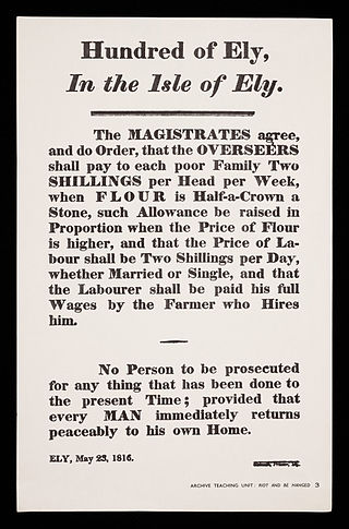
The Ely and Littleport riots of 1816, also known as the Ely riots or Littleport riots, occurred between 22 and 24 May 1816 in the Isle of Ely. The riots were caused by high unemployment and rising grain costs, similar to the general unrest which spread throughout England following the Napoleonic Wars.

<span class="mw-page-title-main">Black Horse Drove</span> Human settlement in England

Black Horse Drove is a linear hamlet that lies 7 miles (11 km) north-north-east of Ely in Cambridgeshire, England, in the civil parish of Littleport. The hamlet is off the Ten Mile Bank, a long road which runs along the north-western bank of the river Great Ouse between Littleport and Southery in Norfolk. Black Horse Drove is in the Fens and much of the village is around 6 feet (1.8 m) below sea level.

<span class="mw-page-title-main">Little Ouse, Cambridgeshire</span>

Little Ouse is a hamlet in Littleport parish, East Cambridgeshire, England, about 3.5 miles (6 km) north-east of Littleport village. It lies on the left bank of the River Little Ouse, which here marks the boundary between Cambridgeshire and Norfolk.