Mare Fen

Last updated

Mare Fen
Mare Fen - geograph.org.uk - 752078.jpg
TypeLocal Nature Reserve
LocationSwavesey, Cambridgeshire, England
OS grid TL 366 698
Area16.3 hectares
Managed byNot known

Mare Fen is a 16.3 hectare Local Nature Reserve north of Swavesey in Cambridgeshire, England. It is owned by Cambridgeshire County Council, [1] [2] and was formerly managed by the Cambridgeshire and Isle of Ely Naturalists Trust (now part of the Wildlife Trust for Bedfordshire, Cambridgeshire and Northamptonshire), [3] but as of December 2016 it is not listed on the Trust's web site. [4] In 2015 Swavesey Parish Council expressed concern at the failure of the Environment Agency to carry out flood prevention works at Mare Fen. [5]

Swavesey village in the United Kingdom

Swavesey is a village lying on the Greenwich Meridian in Cambridgeshire, England, with a population of 2,463. The village is situated 9 miles to the north west of Cambridge and 3 miles south east of St Ives.

Cambridgeshire County of England

Cambridgeshire is a county in the East of England, bordering Lincolnshire to the north, Norfolk to the north-east, Suffolk to the east, Essex and Hertfordshire to the south, and Bedfordshire and Northamptonshire to the west. The city of Cambridge is the county town. Modern Cambridgeshire was formed in 1974 as an amalgamation of the counties of Cambridgeshire and Isle of Ely and Huntingdon and Peterborough, the former covering the historic county of Cambridgeshire and the latter covering the historic county of Huntingdonshire and the Soke of Peterborough, historically part of Northamptonshire. It contains most of the region known as Silicon Fen.

Cambridgeshire County Council British administrative body

Cambridgeshire County Council is the county council of Cambridgeshire, England. The council consists of 61 councillors, representing 59 electoral divisions. The Conservative Party took control of the council at the 2017 election after four years of no party having overall control. The council meets at Shire Hall in Cambridge. It is a member of the East of England Local Government Association.

This pasture in the floodplain of the River Great Ouse is used for grazing in the summer and allowed to flood in the winter. It has wildfowl such as mute swans, wigeons, teal and shovelers, mammals include badgers and muntjac deer. There are diverse aquatic plants. [6]

River Great Ouse river in the United Kingdom

The River Great Ouse is a river in the United Kingdom, the longest of several British rivers called "Ouse". From Syresham in central England, the Great Ouse flows into East Anglia before entering the Wash, a bay of the North Sea. With a course of 143 miles (230 km), mostly flowing north and east, it is the one of the longest rivers in the United Kingdom. The Great Ouse has been historically important for commercial navigation, and for draining the low-lying region through which it flows; its best-known tributary is the Cam, which runs through Cambridge. Its lower course passes through drained wetlands and fens and has been extensively modified, or channelised, to relieve flooding and provide a better route for barge traffic. Though the unmodified river probably changed course regularly after floods, it now enters the Wash after passing through the port of King's Lynn, south of its earliest-recorded route to the sea.

Mute swan species of bird

The mute swan is a species of swan and a member of the waterfowl family Anatidae. It is native to much of Eurasia, and the far north of Africa. It is an introduced species in North America - home to the largest populations outside of its native range - with additional smaller introductions in Australasia and southern Africa. The name 'mute' derives from it being less vocal than other swan species. Measuring 125 to 170 cm in length, this large swan is wholly white in plumage with an orange beak bordered with black. It is recognisable by its pronounced knob atop the beak, which is larger in males.

Wigeon subgenus of birds

The wigeons or widgeons are a group of birds, dabbling ducks currently classified in the genus Mareca along with two other species. There are three extant species of wigeon, in addition to one recently extinct species.

There is access from Station Road.

Related Research Articles

Ouse Washes nature reserve in the United Kingdom

Ouse Washes is a linear 2,513.6 hectare biological Site of Special Scientific Interest stretching from near St Ives in Cambridgeshire to Downham Market in Norfolk. It is also a Ramsar internationally important wetland site, a Special Protection Area under the European Union Birds Directive, a Special Area of Conservation, and a Nature Conservation Review site, Grade I. An area of 186 hectares between March and Ely is managed by the Wildlife Trust for Bedfordshire, Cambridgeshire and Northamptonshire, and another area near Chatteris is managed by the Royal Society for the Protection of Birds. The Wildfowl & Wetlands Trust manages another area near Welney.

Wildlife Trust for Bedfordshire, Cambridgeshire and Northamptonshire registered charity which manages 126 nature reserves covering 3,945 hectares across Bedfordshire, Cambridgeshire and Northamptonshire in the United Kingdom

The Wildlife Trust for Bedfordshire, Cambridgeshire and Northamptonshire (WTBCN) is a registered charity which manages 126 nature reserves covering 3,945 hectares. It has over 35,000 members, and 95% of people in Bedfordshire, Cambridgeshire and Northamptonshire live within five miles of a reserve. In the year to 31 March 2016 it employed 105 people and had an income of £5.1 million. It aims to conserve wildlife, inspire people to take action for wildlife, offer advice and share knowledge. The WTBCN is one of 36 wildlife trusts covering England, and 47 covering the whole of the United Kingdom.

Great Fen nature reserve in the United Kingdom

The Great Fen is a habitat restoration project being undertaken on The Fens in the county of Cambridgeshire in the United Kingdom. It is one of the largest restoration projects in the country, and aims to create a 3,700 hectare wetland and aims to connect Woodwalton Fen National Nature Reserve (NNR), Holme Fen NNR and other nature reserves to create a larger site with conservation benefits for wildlife and socio-economic benefits for people.

Coopers Hill, Bedfordshire nature reserve in the United Kingdom

Cooper's Hill is an 18.1 hectare biological Site of Special Scientific Interest in Ampthill in Bedfordshire. It was notified under Section 28 of the Wildlife and Countryside Act 1981 in 1984, and the planning authority is Central Bedfordshire Council. A smaller area of 12.7 hectares is also a Local Nature Reserve, Part of the site is managed by the Wildlife Trust for Bedfordshire, Cambridgeshire and Northamptonshire.

The Riddy nature reserve in the United Kingdom

The Riddy is an 8.4 hectare flood meadow and Local Nature Reserve located in Sandy, Bedfordshire, United Kingdom, bordering the River Ivel. Owned by Sandy Town Council but managed by both the Wildlife Trust for Bedfordshire, Cambridgeshire and Northamptonshire and Bedfordshire Rural Communities Charity, the 7.7 hectares site gains its name from a small stream which flows through the eastern end of the reserve. The different habitats in the Riddy support a diverse range of species, including a multiplicity of grasses and flowering plants in the meadows, aquatic plants and water voles which inhabit the ditches, ponds and stream, and birds which feed and hunt across the reserve.

Eye Green Local Nature Reserve

Eye Green Local Nature Reserve is a 12 hectare Local Nature Reserve in Eye Green in Cambridgeshire. It was managed by the Wildlife Trust for Bedfordshire, Cambridgeshire and Northamptonshire until September 2016, when management was transferred to its owner, Peterborough City Council. A small part is also in the Eye Gravel Pit geological Site of Special Scientific Interest.

Upwood Meadows nature reserve in the United Kingdom

Upwood Meadows is a 6 hectare biological Site of Special Scientific Interest west of Upwood in Cambridgeshire. It is also a National Nature Reserve and a Grade I Nature Conservation Review site. It is managed by the Wildlife Trust for Bedfordshire, Cambridgeshire and Northamptonshire.

Roswell Pits nature reserve in the United Kingdom

Roswell Pits is an 8 hectare nature reserve on the eastern outskirts of Ely in Cambridgeshire. It is managed by the Environment Agency. It is part of the Ely Pits and Meadows Site of Special Scientific Interest (SSSI)) and Geological Conservation Review site. The SSSI designation for both biological and geological interest. The site was formerly managed by the Wildlife Trust for Bedfordshire, Cambridgeshire and Northamptonshire.

Beechwoods nature reserve in the United Kingdom

Beechwoods is a 9.8 hectare Local Nature Reserve south-east of Cambridge. It is owned by County Farms and managed by the Wildlife Trust for Bedfordshire, Cambridgeshire and Northamptonshire.

Lings Wood Nature Reserve nature reserve in the United Kingdom

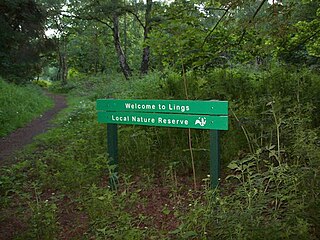
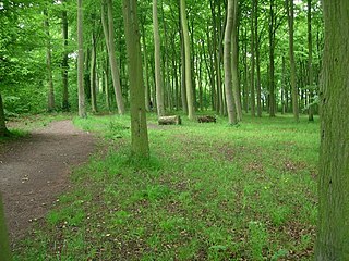
Lings Wood is a 20.1 hectare Local Nature Reserve in eastern Northampton. It is owned by Northampton Borough Council and managed by the Wildlife Trust for Bedfordshire, Cambridgeshire and Northamptonshire.

Warboys and Wistow Woods nature reserve in the United Kingdom

Warboys and Wistow Woods is a 44.5 hectare biological Site of Special Scientific Interest north of Warboys and west of Wistow in Cambridgeshire. Wistow Wood is an 8.5 hectare nature reserve owned and managed by the Wildlife Trust for Bedfordshire, Cambridgeshire and Northamptonshire.

Lattersey Field nature reserve in the United Kingdom

Lattersey Field is an 11.9 hectare Local Nature Reserve in Whittlesey in Cambridgeshire. It is owned by Fenland District Council and managed by the Wildlife Trust for Bedfordshire, Cambridgeshire and Northamptonshire.

Farthinghoe Nature Reserve nature reserve in the United Kingdom

Farthinghoe Nature Reserve is a 3.7 hectare Local Nature Reserve north-west of Brackley in Northamptonshire. It is owned by Northamptonshire County Council and managed by the Wildlife Trust for Bedfordshire, Cambridgeshire and Northamptonshire.

Kingsthorpe Meadow nature reserve in the United Kingdom

Kingsthorpe Meadow is a 14.4 hectare Local Nature Reserve in Northampton. It is owned by Northampton Borough Council and managed by the Wildlife Trust for Bedfordshire, Cambridgeshire and Northamptonshire.

Titchmarsh Nature Reserve nature reserve in the United Kingdom

Titchmarsh Nature Reserve is a 72.7 hectare Local Nature Reserve north of Thrapston in East Northamptonshire. It is owned and managed by the Wildlife Trust for Bedfordshire, Cambridgeshire and Northamptonshire. It is part of the Upper Nene Valley Gravel Pits Site of Special Scientific Interest.

Stortons Pits nature reserve in the United Kingdom

Storton's Pits is a 21.9 hectare Local Nature Reserve in Northampton. It is managed by the Wildlife Trust for Bedfordshire, Cambridgeshire and Northamptonshire.

References

  1. "Mare Fen". Local Nature Reserves. Natural England. 21 February 2013. Retrieved 15 December 2016.
  2. "Map of Mare Fen". Local Nature Reserves. Natural England. Retrieved 15 December 2016.
  3. "Celebrating Sir David Attenborough at 90". [Wildlife Trust for Bedfordshire, Cambridgeshire and Northamptonshire. 7 May 2016.
  4. "Find a nature reserve". Wildlife Trust for Bedfordshire, Cambridgeshire and Northamptonshire. Retrieved 15 December 2016.
  5. "Response to the Environment Agency Produced Document Entitled: Briefing for Northstowe Joint Development Control Committee, 25th March 2015, Swavesey Drain Conveyance Improvements Project" (PDF). Swavesey Parish Council. Retrieved 15 December 2016.
  6. "Mare Fen". Cambridgeshire County Council. Archived from the original on 20 December 2016. Retrieved 15 December 2016.

Coordinates: 52°18′32″N0°00′08″E / 52.309°N 0.0022°E / 52.309; 0.0022

Geographic coordinate system Coordinate system

A geographic coordinate system is a coordinate system that enables every location on Earth to be specified by a set of numbers, letters or symbols. The coordinates are often chosen such that one of the numbers represents a vertical position and two or three of the numbers represent a horizontal position; alternatively, a geographic position may be expressed in a combined three-dimensional Cartesian vector. A common choice of coordinates is latitude, longitude and elevation. To specify a location on a plane requires a map projection.