Somersham Local Nature Reserve

Last updated
Somersham Local Nature Reserve
Somersham Local Nature Reserve 2.jpg
Type Local Nature Reserve
Location Somersham, Cambridgeshire
OS grid TL 366 781
Area 8.9 hectares
Managed by Cambridgeshire County Council and Somersham Parish Council

Somersham Local Nature Reserve is an 8.9 hectare Local Nature Reserve in Somersham in Cambridgeshire. It is owned and managed by Cambridgeshire County Council and Somersham Parish Council. [1] [2]

Somersham village located in Huntingdonshire, United Kingdom

Somersham is a village and civil parish in Cambridgeshire, England. Somersham lies approximately 9 miles (14 km) east of Huntingdon and 4 miles (6 km) north of St Ives. Somersham is situated within Huntingdonshire which is a non-metropolitan district of Cambridgeshire as well as being a historic county of England.

Cambridgeshire County of England

Cambridgeshire is a county in the East of England, bordering Lincolnshire to the north, Norfolk to the north-east, Suffolk to the east, Essex and Hertfordshire to the south, and Bedfordshire and Northamptonshire to the west. The city of Cambridge is the county town. Modern Cambridgeshire was formed in 1974 as an amalgamation of the counties of Cambridgeshire and Isle of Ely and Huntingdon and Peterborough, the former covering the historic county of Cambridgeshire and the latter covering the historic county of Huntingdonshire and the Soke of Peterborough, historically part of Northamptonshire. It contains most of the region known as Silicon Fen.

Cambridgeshire County Council British administrative body

Cambridgeshire County Council is the county council of Cambridgeshire, England. The council consists of 61 councillors, representing 59 electoral divisions. The Conservative Party took control of the council at the 2017 election after four years of no party having overall control. The council meets at Shire Hall in Cambridge. It is a member of the East of England Local Government Association.

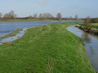
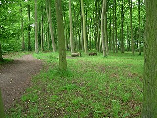
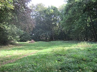
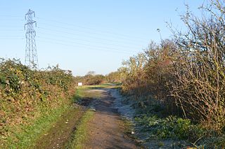
Habitats in this reserve are a lake, wetland, grassland and woodland. Invertebrates include grass snakes and common lizards, there are birds such as great crested grebes, and flora such as red bartsia and purple loosestrife. [1]

Grass snake species of reptile

The grass snake, sometimes called the ringed snake or water snake, is a Eurasian non-venomous snake. It is often found near water and feeds almost exclusively on amphibians. The barred grass snake, Natrix helvetica, was split off as a separate species in 2017.

Great crested grebe species of bird

The great crested grebe is a member of the grebe family of water birds noted for its elaborate mating display. Its scientific name comes from Latin: the genus name Podiceps is from podicis, "vent" and pes, "foot", and is a reference to the placement of a grebe's legs towards the rear of its body; the species name, cristatus, means "crested".

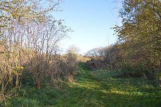
There is access from Station Approach, named after the former Somersham railway station. The nature reserve includes a section of disused railway land, part of the March branch of the former Great Eastern Railway.

Somersham railway station

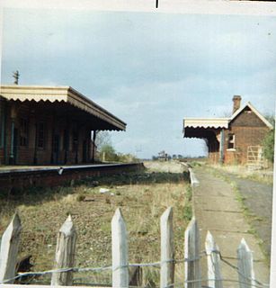
Somersham railway station was a station in Somersham, Cambridgeshire on the Great Eastern Railway between March and St Ives. There was also a branch line that ran north-west from the station to Ramsey. It opened in 1848, but was closed on 6 March 1967.

Great Eastern Railway pre-grouping British railway company

The Great Eastern Railway (GER) was a pre-grouping British railway company, whose main line linked London Liverpool Street to Norwich and which had other lines through East Anglia. The company was grouped into the London and North Eastern Railway in 1923.

Related Research Articles

Byrons Pool

Byron's Pool is a 4.4 hectare Local Nature Reserve in Grantchester in Cambridgeshire. It is managed by Cambridge City Council and the City Greenways Project.

Cherry Hinton Pit nature reserve in the United Kingdom

Cherry Hinton Pit is a 12.8 hectare biological Site of Special Scientific Interest (SSSI) on the south-eastern outskirts of Cambridge. The site consists of East Pit and most of the smaller West Pit. East Pit is part of the Limekiln Close and East Pit Local Nature Reserve, which is managed by the Wildlife Trust for Bedfordshire, Cambridgeshire and Northamptonshire under the name Cherry Hinton Chalk Pits. West Pit is a separate Local Nature Reserve (LNR).

Mare Fen

Mare Fen is a 16.3 hectare Local Nature Reserve north of Swavesey in Cambridgeshire, England. It is owned by Cambridgeshire County Council, and was formerly managed by the Cambridgeshire and Isle of Ely Naturalists Trust, but as of December 2016 it is not listed on the Trust's web site. In 2015 Swavesey Parish Council expressed concern at the failure of the Environment Agency to carry out flood prevention works at Mare Fen.

Woodston Ponds nature reserve in the United Kingdom

Woodston Ponds is an 8.9 hectare Local Nature Reserve between the River Nene and the Nene Valley Railway in Peterborough in Cambridgeshire. It is managed by the Wildlife Trust for Bedfordshire, Cambridgeshire and Northamptonshire.

Beechwoods nature reserve in the United Kingdom

Beechwoods is a 9.8 hectare Local Nature Reserve south-east of Cambridge. It is owned by County Farms and managed by the Wildlife Trust for Bedfordshire, Cambridgeshire and Northamptonshire.

Melwood Local Nature Reserve

Melwood is a 0.6 hectare Local Nature Reserve in Meldreth in Cambridgeshire, England. It is owned by Cambridgeshire County Council and managed by the Melwood Conservation Group.

Isleham Nature Reserve

Isleham Nature Reserve is a 1.1 hectare Local Nature Reserve in Isleham in Cambridgeshire. It is owned by Cambridgeshire County Council and managed by the council together with the Friends of Isleham Nature Reserves.

Rings End Local Nature Reserve

Ring's End is an 8.5 hectare Local Nature Reserve which runs south from the hamlet of Ring's End towards March in Cambridgeshire. It is owned and managed by Cambridgeshire County Council.

Little Paxton Pits

Little Paxton Pits is a 127.4 hectare biological Site of Special Scientific Interest in Little Paxton in Cambridgeshire. Part of it is also a 60 hectare Local Nature Reserve (LNR).

Kingston and Bourn Old Railway

Kingston and Bourn Old Railway or Kingston Amenity Area is a linear 1.9-hectare (4.7-acre) Local Nature Reserve between Kingston and Bourn in Cambridgeshire, England. It is owned and managed by Cambridgeshire County Council.

Lattersey Field nature reserve in the United Kingdom

Lattersey Field is an 11.9 hectare Local Nature Reserve in Whittlesey in Cambridgeshire. It is owned by Fenland District Council and managed by the Wildlife Trust for Bedfordshire, Cambridgeshire and Northamptonshire.

Farthinghoe Nature Reserve nature reserve in the United Kingdom

Farthinghoe Nature Reserve is a 3.7 hectare Local Nature Reserve north-west of Brackley in Northamptonshire. It is owned by Northamptonshire County Council and managed by the Wildlife Trust for Bedfordshire, Cambridgeshire and Northamptonshire.

Kingsthorpe Meadow nature reserve in the United Kingdom

Kingsthorpe Meadow is a 14.4 hectare Local Nature Reserve in Northampton. It is owned by Northampton Borough Council and managed by the Wildlife Trust for Bedfordshire, Cambridgeshire and Northamptonshire.

Limekiln Close and East Pit

Limekiln Close and East Pit is a 10 hectare Local Nature Reserve (LNR) in Cherry Hinton, on the south-eastern outskirts of Cambridge. It is managed by the Wildlife Trust for Bedfordshire, Cambridgeshire and Northamptonshire as Cherry Hinton Chalk Pits. East Pit is part of the Cherry Hinton Pit biological Site of Special Scientific Interest, which excludes Limekiln Close but includes the neighbouring West Pit.

Barnes Meadow nature reserve in the United Kingdom

Barnes Meadow is a 29.4 hectare Local Nature Reserve in Northampton. An area of 20 hectares is managed by the Wildlife Trust for Bedfordshire, Cambridgeshire and Northamptonshire.

Bradlaugh Fields nature reserve in the United Kingdom

Bradlaugh Fields is a 60 hectare open space in Northampton. The site is a former golf course. In 1987 it was proposed to build housing on the site, but after a campaign by local residents it was acquired by Northampton Borough Council and opened as a wildlife park in 1998. It was named after Charles Bradlaugh, a leading nineteenth century radical and atheist who was MP for Northampton. Three fields with a total area of 17.5 hectares are managed by the Wildlife Trust for Bedfordshire, Cambridgeshire and Northamptonshire as a nature reserve also called Bradlaugh Fields. Hills and Holes is at the southern end and two adjoining meadows, Scrub Field and Quarry Field, are at the northern end. Hills and Holes is an 8.3 hectare Local Nature Reserve (LNR) and Scrub Field is a 5.1 hectare LNR.

References

  1. 1 2 "Somersham". Local Nature Reserves. Natural England. 21 February 2013. Retrieved 4 December 2016.
  2. "Map of Somersham (LNR)". Local Nature Reserves. Natural England. Retrieved 4 December 2016.

Coordinates: 52°23′02″N0°00′22″E / 52.384°N 0.006°E / 52.384; 0.006

Geographic coordinate system Coordinate system

A geographic coordinate system is a coordinate system that enables every location on Earth to be specified by a set of numbers, letters or symbols. The coordinates are often chosen such that one of the numbers represents a vertical position and two or three of the numbers represent a horizontal position; alternatively, a geographic position may be expressed in a combined three-dimensional Cartesian vector. A common choice of coordinates is latitude, longitude and elevation. To specify a location on a plane requires a map projection.