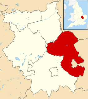
East Cambridgeshire is a local government district in Cambridgeshire, England. Its council is based in Ely. The population of the District Council at the 2011 Census was 83,818.

Cooper's Hill is an 18.1 hectare biological Site of Special Scientific Interest in Ampthill in Bedfordshire. It was notified under Section 28 of the Wildlife and Countryside Act 1981 in 1984, and the planning authority is Central Bedfordshire Council. A smaller area of 12.7 hectares is also a Local Nature Reserve, Part of the site is managed by the Wildlife Trust for Bedfordshire, Cambridgeshire and Northamptonshire.

Cherry Hinton Pit is a 12.8 hectare biological Site of Special Scientific Interest (SSSI) on the south-eastern outskirts of Cambridge. The site consists of East Pit and most of the smaller West Pit. East Pit is part of the Limekiln Close and East Pit Local Nature Reserve, which is managed by the Wildlife Trust for Bedfordshire, Cambridgeshire and Northamptonshire under the name Cherry Hinton Chalk Pits. West Pit is a separate Local Nature Reserve (LNR).

Dogsthorpe Star Pit is a 36.4 hectare biological Site of Special Scientific Interest (SSSI)) on the eastern outskirts of Peterborough in Cambridgeshire. It is also designated a Local Nature Reserve, and it is managed by the Wildlife Trust for Bedfordshire, Cambridgeshire and Northamptonshire.
Eye Green Local Nature Reserve is a 12 hectare Local Nature Reserve in Eye Green in Cambridgeshire. It was managed by the Wildlife Trust for Bedfordshire, Cambridgeshire and Northamptonshire until September 2016, when management was transferred to its owner, Peterborough City Council. A small part is also in the Eye Gravel Pit geological Site of Special Scientific Interest.
Mare Fen is a 16.3 hectare Local Nature Reserve north of Swavesey in Cambridgeshire, England. It is owned by Cambridgeshire County Council, and was formerly managed by the Cambridgeshire and Isle of Ely Naturalists Trust, but as of December 2016 it is not listed on the Trust's web site. In 2015 Swavesey Parish Council expressed concern at the failure of the Environment Agency to carry out flood prevention works at Mare Fen.
Woodston Ponds is an 8.9 hectare Local Nature Reserve between the River Nene and the Nene Valley Railway in Peterborough in Cambridgeshire. It is managed by the Wildlife Trust for Bedfordshire, Cambridgeshire and Northamptonshire.
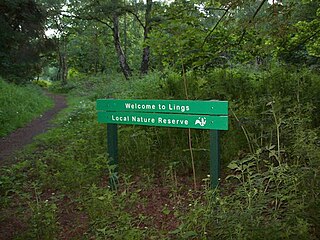
Lings Wood is a 20.1 hectare Local Nature Reserve in eastern Northampton. It is owned by Northampton Borough Council and managed by the Wildlife Trust for Bedfordshire, Cambridgeshire and Northamptonshire.
Melwood is a 0.6 hectare Local Nature Reserve in Meldreth in Cambridgeshire, England. It is owned by Cambridgeshire County Council and managed by the Melwood Conservation Group.
Ring's End is an 11 hectare Local Nature Reserve which runs south from the hamlet of Ring's End towards March in Cambridgeshire. It is owned by Cambridgeshire County Council, and managed by the Friends of Ring's End Nature Reserve Group. Ring's End is known as a 'post-industrial habitat' since it is reclaimed industrial land.

Somersham Local Nature Reserve is an 8.9 hectare Local Nature Reserve in Somersham in Cambridgeshire. It is owned and managed by Cambridgeshire County Council and Somersham Parish Council.

St Denis' Church, East Hatley is a de-consecrated church in East Hatley in Cambridgeshire, England. It is a listed building, Grade 2*, and the building and its churchyard are a 200 square metre Local Nature Reserve. It is owned and managed by the Friends of Friendless Churches.

Kingston and Bourn Old Railway or Kingston Amenity Area is a linear 1.9-hectare (4.7-acre) Local Nature Reserve between Kingston and Bourn in Cambridgeshire, England. It is owned and managed by Cambridgeshire County Council.

Lattersey Field is an 11.9 hectare Local Nature Reserve in Whittlesey in Cambridgeshire. It is owned by Fenland District Council and managed by the Wildlife Trust for Bedfordshire, Cambridgeshire and Northamptonshire.

Kingsthorpe Meadow is a 14.4 hectare Local Nature Reserve in Northampton. It is owned by Northampton Borough Council and managed by the Wildlife Trust for Bedfordshire, Cambridgeshire and Northamptonshire.

Limekiln Close and East Pit is a 10 hectare Local Nature Reserve (LNR) in Cherry Hinton, on the south-eastern outskirts of Cambridge. It is managed by the Wildlife Trust for Bedfordshire, Cambridgeshire and Northamptonshire as Cherry Hinton Chalk Pits. East Pit is part of the Cherry Hinton Pit biological Site of Special Scientific Interest, which excludes Limekiln Close but includes the neighbouring West Pit.

Bradlaugh Fields is a 60 hectare open space in Northampton. The site is a former golf course. In 1987 it was proposed to build housing on the site, but after a campaign by local residents it was acquired by Northampton Borough Council and opened as a wildlife park in 1998. It was named after Charles Bradlaugh, a leading nineteenth century radical and atheist who was MP for Northampton. Three fields with a total area of 17.5 hectares are managed by the Wildlife Trust for Bedfordshire, Cambridgeshire and Northamptonshire as a nature reserve also called Bradlaugh Fields. Hills and Holes is at the southern end and two adjoining meadows, Scrub Field and Quarry Field, are at the northern end. Hills and Holes is an 8.3 hectare Local Nature Reserve (LNR) and Scrub Field is a 5.1 hectare LNR.

