The civil parish has an area of 5.2 km² and in the 2021 census had a population of 11,352 in 4,637 households.[3]
Fire Station in 2006, now a heritage centre
It was an agricultural centre, developing as a market for the produce of the Fens with a bridge across the Ouse. During the Middle Ages, it was famed for its butter market and also hosted a notable horse fair. The market is now held on Fridays and Saturdays.
Notable buildings in the town include its medievalparish church, dedicated to St Edmund, and the Victorianclock tower, constructed in 1878. The town is also known as the place where Charles I hid after the Battle of Naseby. In 2004 the town completed a regeneration project on the Market Place, moving the market to the town hall car park. The decorative town sign depicts the crown and arrows of St Edmund with horses to show the importance of the horse fairs in the town's history.
A heritage centre, Discover Downham, opened in a former fire station in 2016.[4] The town is twinned with Civray, Vienne, France.[5]
Toponymy
The towns name means "Hill homestead/village" with a market. The town is situated on a terrace overlooking the Great Ouse.
Historically, Downham Market was an important market centre for the surrounding agricultural area. It incorporated a famous horse fair and weekly livestock and butter markets. There were several maltings in the town supplying the brewing trade in the town at a time when beer was often safer to drink than well water.
Before the arrival of the railway in 1846, the riverside was largely agricultural with warehousing for river transport centred on the Great Ouse at Downham West. With the coming of the railway, there was a rapid industrial and residential development into Downham Market.[8]
Jacob Mason Bird built his steam mill by the railway. The mill, now run by Heygates, is still known as Bird’s Mill.[9] Other industries grew as the railway became the focus for warehousing, the loading of cattle and products, and the building of railway housing.
Today, Downham Market has seen rapid residential development and has become commuter town for Cambridge. The town has a market on Fridays and Saturdays.
Landmarks
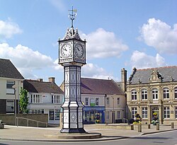
Town clock
The Town Clock, erected by William Cunliffe in 1878, is a Grade II listed structure. Made of cast iron, the clock was originally bronzed and relieved on the prominent parts with gold. Later the clock was painted bottle green, and its current black-and-white finish was applied during the 2004 restoration.[10]
War memorial
The town's war memorial stands at the junction of London Road and Church Road. It was dedicated in October 1921 to the dead of World War I. It was paid for by public subscription and built by H. J. Long, a local stonemason. The memorial originally commemorated 73 local servicemen who fell in the First World War with the names of the dead of World War II added later. In 2005, Evelyn Irene Murrell, who died in 1918,[11] a member of the WRAF was belatedly added to the list of names. The memorial bears the crown-and-arrows symbol of the town and of the martyred King St Edmund of East Anglia to whom the church is dedicated.
Downham Market is sometimes known as the "Gingerbread Town" because of the characteristic local carrstone used for buildings since medieval times.[citation needed]
St Edmund's Church is a good example of this and is Downham's only Grade I listed building. It stands in a prominent position overlooking the flat Fenlands to the west. The church, like the town, was probably an Anglo-Saxon foundation but rebuilt in the 13th-century (Early English period) and extensively altered in the 15th and 16th centuries (Perpendicular and Tudor periods).[12]
The Old Court House, located on London Road, was where the magistrates dispensed justice in the Clackclose Hundred from 1861.[13][14]
The Castle Hotel is Grade II listed and features a distinctive battlemented parapet. It is a mainly 18th-century building, but the core is probably earlier.[15] In the past, visitors stayed here for hunting, shooting and fishing in the local area. The hotel had its own transport to and from railway station, and out on shooting parties. The building closed as a hotel and restaurant in 2020 and is set to be redeveloped into flats.[16]
Downham Market Town Hall, on the west side of the old Market Hill, was built by public subscription in 1887/8.[17]
Opposite the Town Hall is a coaching inn, the Crown Hotel. Just inside the arched entrance are steps leading to a mounting block for horsemen. Before the Court House was built, magistrates met here. In May 1816 it was the scene of riots when the magistrates were besieged by angry, starving agricultural labourers demanding a living wage of two shillings a day and the release of poachers. Two of the Downham rioters, Daniel Harwood and Thomas Thody, were hanged on 31 August 1816.[18]
The 18th-century Dial House, located on Station Road, was once a private school for gentlemen in the 1860s.[19] Its name is derived from the sundial painted high on the wall. Today the building is a bed and breakfast.[20]
The town is served on Mondays - Saturdays by Lynx route 37 to Southery and King's Lynn.[23] and by less regular "Go to town" services 47, 60 and 61 to Fincham, Three Holes, Swaffham and King's Lynn.[24] There are no buses serving the town on Sundays.
Road
Downham Market is on the north–south A10 road from London to King's Lynn. The east-west A1122 from Outwell to Swaffham runs south of the town.
River
The River Great Ouse and Great Ouse Relief Channel flows through the western boundary of the town.
The Great Ouse Relief Channel was made navigable in 2001, when the Environment Agency constructed a lock at Denver to provide access. Moorings are located next to the Station Road bridge.[25] The river is a popular spot for boating and swimming.
Education
There are two primary schools in Downham Market: Hillcrest Primary School and Nelson Academy.
Nelson Academy, situated on Nursery Road, was originally named Clackclose Community Primary School after Clackclose Hundred. The school opened in 1873 on Snape Lane. It was the first primary education academy sponsored by the CWA Academy Trust, founded by the College of West Anglia, in 2014. It is named after Lord Nelson who, according to local folklore, attended his first school in Downham Market.[26]
Hillcrest Primary School is on Bexwell Road, and was opened in 1980 as Hillcrest First and Middle School. It is named after Hillcrest, the road connecting Bexwell Road and Civray Avenue. In 2018, the school began work on a new £4.5m nine classroom building.[27]
Downham Market Academy, formerly Downham Market GM High School, is a secondary school and sixth form with academy status, The academy was launched on 1 July 2013, sponsored by the CWA Academy Trust founded by the College of West Anglia. Teaching is shared between two sites, with the main Bexwell campus housing pupils years 7–11 (ages 11–16) and the Downham Market Academy Sixth Form (formerly Downham Market College) campus offering A-levels to sixth form pupils years 12–13 (ages 16–18).
Downham Preparatory School and Montessori Nursery is a non-selective Independent Preparatory School for girls and boys aged three months to 13 years. The school was founded by its present (2021) owner, Elizabeth Laffeaty-Sharpe, in 1984 for children aged two to five years.
The Priory Centre holds the Downham Market Library.[28]
The War Memorial Playing Fields includes a children's playground, tennis courts and a multi-purpose sports court. A non-league football club, Downham Town, currently members of the Isthmian League North Division play at the Memorial Field.
The Willows nature reserve was once one of the town's brickfields.
The Jubilee Community Centre, located on Howdale Road, hosts local workshops, classes, childcare and community events. The Community Centre has a large field adjacent.
The Downham Market Heritage Centre includes interactive displays focused on local history. The centre includes free Wi-Fi, an internet café and research facilities with small library.
Notable residents
George William Manby (1765–1854), inventor of the Manby mortar and the first modern form of fire extinguisher, was educated in the town.
This page is based on this Wikipedia article Text is available under the CC BY-SA 4.0 license; additional terms may apply. Images, videos and audio are available under their respective licenses.