West Walton

Last updated

West Walton
West Walton village sign.jpg
The village sign, West Walton, Norfolk
Norfolk UK location map.svg
Red pog.svg
West Walton
Location within Norfolk
Area15.77 km2 (6.09 sq mi)
Population1,731 (parish, 2011 census)
  Density 110/km2 (280/sq mi)
OS grid reference TF4713
  London 80 miles (130 km)
Civil parish
  • West walton
District
Shire county
Region
Country England
Sovereign state United Kingdom
Post town WISBECH
Postcode district PE14
Dialling code 01945
Police Norfolk
Fire Norfolk
Ambulance East of England
UK Parliament
List of places
UK
England
Norfolk
52°41′50″N0°10′36″E / 52.69725°N 0.17664°E / 52.69725; 0.17664

West Walton is a village and civil parish in the King's Lynn and West Norfolk District of Norfolk, England. [1]

Contents

The parish of West Walton, in the 2001 Census, had a population of 1,659, increasing to 1,731 at the 2011 Census. [2]

History

The name West Walton is thought by James Rye to derive from the Old English meaning of the 'settlement by the wall' which refers to the village's proximity to a Roman sea wall or defence. [3]

West Walton was established by the time of the Norman Conquest. The village's population, land ownership and productive resources were detailed in its entry in the Domesday Book of 1085. [4] In the great book West Walton is recorded by the name 'Waltuna'. The parish was held by William de Warenne with the Abbot of St Peter and St Paul, Cluny from him, The Abbot of Ely before and after 1066, and Oder from Ralph de Beufour. The survey mentions ½ church, 38 salt houses and 1100 sheep. The survey also records the presence of a fishery. In the Domesday survey fractions were used to indicate that the entry, in this case the church, was situated within more than one parish. [5]

Geography

The village and parish of West Walton is in the western part of the county of Norfolk. The western flank of the parish is also the county border between Norfolk and Cambridgeshire and is also the course of the River Nene. On the southern flank is the parish of Walsoken. To the north is Walpole and to the east is Marshland St James.

The village is 47 miles (80 km) west-north-west of Norwich, 10 miles (20 km) west-south-west of King's Lynn and 80 miles (100 km) north of London and its location makes it, along with Walsoken, the most westerly village in Norfolk. The nearest town is Wisbech which is 2 miles (3.2 km) south of the village. The nearest railway station is at Watlington, Norfolk for the Fen Line which runs between King's Lynn and Cambridge. The nearest airport is Norwich International Airport.

Governance

For the purposes of local government, the parish falls within the district of King's Lynn and West Norfolk.

West Walton parish council has 11 councillors. The councillors elect a chair. West Walton is part of the electoral ward of Walton. The population of this ward at the 2011 Census was 2,641. [6]

Landmarks

Church

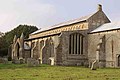
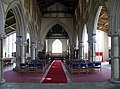
St Mary's Church dates from the 13th century built about 1240. [7] The church's campanile, or bell tower is detached about 60 feet from the main building of the church. [8] The tower is supported at its base by four open arches. At each corner is a buttress which rises pinnacles with gabled niches in the first, second and third storey. [8] The tower is topped with a carved parapet walls. The west doorway to the church is flanked on either side by buttresses, a result of remedial works carried out here after the foundations failed [8] not long after the church was built. The south porch is arched with arcaded buttress on each side. [8] The nave is arcaded with six bays on each side. The arches are supported on pillars which are encircled by detached shafts topped with capitals of stone carved foliage. [8] The hammerbeam roof dates from the 15th century and is supported by 24 carved angels holding shields. [8]

The bell tower, [9] and the church, [10] are both recorded in the National Heritage List for England as Grade I listed buildings. The bell tower is under the care of the Churches Conservation Trust. [11] The tower is 77 feet high (23 metres) high to parapet, or 90 feet (27 metres) high when the pinnacles are included. [12]

The church's rector was Edward Everard Blencowe (1806–1895) and in 1847 his sister Agnes Blencowe met the architect George Edmund Street here. Agnes was said to be the "best workwoman in England" and she and George Edmund Street's sister Mary Ann Street founded the Ladies’ Ecclesiastical Embroidery Society in 1854. The church still has a red and a green stole and a white frontal for the altar which were embroidered by Agnes Blencowe. [13]

Towermill

Ingleborough tower windmill is one mile north of the village, and is in the yard of Hill House Farm along with a house and assorted farm buildings. The mill is now in a state of disuse. [14] It was designated as a Grade II listed building in 1951. [15]

Related Research Articles

<span class="mw-page-title-main">Aylmerton</span> Human settlement in England

Aylmerton is a village in the county of Norfolk, England. It is in the area of North Norfolk and lies 2.2 miles (3.5 km) south of the North Sea, 3.2 miles (5.1 km) south-west of Cromer and 7.5 miles (12.1 km) east of Holt. The parish is bordered by the parishes of Beeston Regis and Runton to the north, West Beckham to the west, Felbrigg to the east and Gresham and Sustead to the south. The centre of the village is ¾ miles south of the A148 King's Lynn to Cromer road with Sandy Lane and Beechwood Avenue north of it. The nearest railway stations are West Runton at the bottom of Sandy Lane, Cromer at 2.9 miles (4.7 km) and Roughton Road at 4.1 miles (6.6 km). The civil parish has an area of 6.86 square kilometres and in the 2001 census the population was 435 in 178 households, increasing to 458 at the 2011 Census. For the purposes of local government, the parish is in North Norfolk, whose headquarters are in Cromer.

<span class="mw-page-title-main">Barton Bendish</span> Village and a civil parish in the English county of Norfolk

Barton Bendish is a civil parish and small ancient village in the English county of Norfolk located 10 miles (16 km) south of King's Lynn and 90 miles (140 km) North East of London. It has two medieval parish churches, and once had three. The parish includes the old hamlet of Eastmoor, and covers 3,936 acres (1,593 ha). The village has been settled since Neolithic times and was expanded during the Saxon period. Today the village has a population of 210 as recorded at the 2010 census and contains eight listed buildings, with the two medieval parishes churches being Grade I.

<span class="mw-page-title-main">Wimbotsham</span> Human settlement in England

Wimbotsham is a village and civil parish in the English county of Norfolk. It is situated close to the River Great Ouse, 2 km (1.2 mi) north of the town of Downham Market, 18 km (11 mi) south of the town of King's Lynn, and 60 km (37 mi) west of the city of Norwich. It covers an area of 6.04 km2 (2.33 sq mi) and had a population of 558 in 262 households at the 2001 census, the population including Bexwell and increasing to 664 at the 2011 Census. For the purposes of local government, it falls within the district of King's Lynn and West Norfolk.

<span class="mw-page-title-main">North Runcton</span> Human settlement in England

North Runcton is a village and a civil parish in the English county of Norfolk. The village is 43.2 miles (69.5 km) west of Norwich, 4.3 miles (6.9 km) south-south-west of King's Lynn and 102 miles (164 km) north of London. The village is located a small distance south-west of the A47 between King's Lynn and Swaffham. The nearest railway station is at King's Lynn for the Fen Line which runs between King's Lynn and Cambridge. The nearest airport is Norwich International Airport. The parish of North Runcton in the 2001 census, has a population of 266, increasing to 549 at the 2011 Census. For the purposes of local government, the parish falls within the district of King's Lynn and West Norfolk.

<span class="mw-page-title-main">Gunthorpe, Norfolk</span> Human settlement in England

Gunthorpe is a village and a civil parish in the English county of Norfolk. The village is 8.6 miles east north east of the town of Fakenham, 14.9 miles west south west of Cromer and 122 miles north north east of London. The nearest railway station is at Sheringham for the Bittern Line which runs between Sheringham, Cromer and Norwich. The nearest airport is Norwich International Airport.

<span class="mw-page-title-main">East Walton</span> Human settlement in England

East Walton is a village in the English county of Norfolk. The village is located 7.8 miles (12.6 km) south-east of King's Lynn and 31 miles (50 km) north-west of Norwich. East Walton constitutes part of the civil parish of West Acre.

<span class="mw-page-title-main">Knapton</span> Human settlement in England

Knapton is a village and a civil parish in the English county of Norfolk. The village is 8.9 miles (14.3 km) southeast of Cromer, 19.4 miles (31.2 km) northeast of Norwich and 134 miles (216 km) northeast of London. The Village is located alongside the B1145 a route which runs between King's Lynn and Mundesley. The nearest railway station is at North Walsham for the Bittern Line which runs between Sheringham, Cromer and Norwich. The nearest airport is Norwich International Airport.

<span class="mw-page-title-main">Babingley</span> Human settlement in England

Babingley is a village and former civil parish, now in the parish of Sandringham, in the King's Lynn and West Norfolk district, in the county of Norfolk, England, about 1 mile (1.6 km) northwest of Castle Rising and 5+12 miles (9 km) north-north-east of King's Lynn. In 1931 the parish had a population of 91. On 1 April 1935 the parish was abolished and merged with Sandringham.

<span class="mw-page-title-main">Fordham, Norfolk</span> Human settlement in England

Fordham is a small village and civil parish in the English county of Norfolk. The village is located 2.2 miles (3.5 km) north of Downham Market and 39 miles (63 km) west of Norwich, located along the A10 between London and King's Lynn and close to the confluence of the River Wissey and River Great Ouse.

<span class="mw-page-title-main">Outwell</span> Human settlement in England

Outwell is a village and civil parish in the borough of King's Lynn and West Norfolk, in the English county of Norfolk.

<span class="mw-page-title-main">Tilney St Lawrence</span> Human settlement in England

Tilney St Lawrence is a village and a civil parish in the English county of Norfolk The village is 52.3 miles (84.2 km) west of Norwich, 9.7 miles (15.6 km) south-south-west of King's Lynn and 104 miles (167 km) north of London. The nearest town is Wisbech which is 8.3 miles (13.4 km) west-south-west of the village. The village lies to the south of the route of the A47 between Peterborough and Kings Lynn. The parish of Tilney St Lawrence in the 2001 census had a population of 1,465, increasing to 1,576 at the 2011 Census. For the purposes of local government, the parish falls within the district of King's Lynn and West Norfolk.

<span class="mw-page-title-main">Walsoken</span> Human settlement in England

Walsoken is a settlement and civil parish in Norfolk, England, which is conjoined as a suburb at the northeast of the town of Wisbech, Isle of Ely, Cambridgeshire.

<span class="mw-page-title-main">Ingleborough Tower Windmill, West Walton</span>

Ingleborough Tower Windmill is one mile north of the village of West Walton in Norfolk, England. The windmill is in the yard of Hill House Farm alongside a house and assorted farm buildings. The mill is now in a state of disuse. The mill tower was listed Grade II in 1951.

<span class="mw-page-title-main">Leziate</span> Human settlement in England

Leziate is a village and civil parish in the English county of Norfolk. The village is 44 miles (71 km) west of Norwich, 5.7 miles (9.2 km) east of King's Lynn and 106 miles (171 km) north-north-east of London. The Village is located a small distance south of the B1145 a route which runs between King's Lynn and Mundesley. The nearest railway station is at King's Lynn for the Fen Line which runs between King's Lynn and Cambridge. The nearest airport is Norwich International Airport. The parish of Leziate in the 2001 census, has a population of 581, including Ashwicken and increasing to 592 at the 2011 census.

<span class="mw-page-title-main">Marston St. Lawrence</span> Human settlement in England

Marston St. Lawrence is a village and civil parish about 4 miles (6.4 km) northwest of Brackley in Northamptonshire. A stream flows through the village and another forms the southern boundary of the parish. The two merge as Farthinghoe Stream, a tributary of the Great Ouse. The 2001 Census recorded the parish population as 209, decreasing slightly to 202 at the 2011 Census.

<span class="mw-page-title-main">St Mary's Church, Purton</span> Church in Wiltshire, England

St Mary's Church in the village of Purton in north Wiltshire, England, is an active Church of England parish church in the Diocese of Bristol. A large building begun in the 13th century and one of only three churches in England to have both a western tower and a central spire, it has been designated as a Grade I listed building by English Heritage.

<span class="mw-page-title-main">St Mary the Virgin's Church, Wiggenhall</span> Church in Norfolk, England

St Mary the Virgin's Church is a redundant Anglican church in the civil parish of Wiggenhall St Germans, Norfolk, England. It is recorded in the National Heritage List for England as a designated Grade I listed building, and is under the care of the Churches Conservation Trust. The church stands at the end of a lane to the north of the village of Wiggenhall St Mary the Virgin, some 5 miles (8 km) south of King's Lynn. It is notable particularly for the quality of carving of its wooden fittings.

<span class="mw-page-title-main">St Mary's Church, Islington, Norfolk</span> Church in Norfolk, England

St Mary's Church is a ruined redundant Anglican church in the civil parish of Tilney St Lawrence, Norfolk, England. It is recorded in the National Heritage List for England as a designated Grade II* listed building, and is under the care of the Churches Conservation Trust. The ruins stand in an isolated position adjacent to Islington Hall Farm, immediately to the south of the A47 road between King's Lynn and Wisbech.

<span class="mw-page-title-main">St Mary's Church, Walton-on-the-Hill</span> Church in Merseyside, England

St Mary's Church is in Walton, Liverpool, Merseyside, England. It is an active Anglican parish church in the deanery of Walton, the archdeaconry of Liverpool and the diocese of Liverpool. Its benefice is united with those of St Nathanael, Walton-on-the-Hill, and St Aidan, Walton-on-the-Hill, to form the Walton Team Ministry. The church is recorded in the National Heritage List for England as a designated Grade II listed building.

<span class="mw-page-title-main">Church of St Katharine, Ickleford</span> Church in Hertfordshire, England

The Church of St Katharine of Alexandria is the Church of England parish church for Ickleford in Hertfordshire. It comes under the diocese of St Albans.

References

  1. OS Explorer Map 235(2006) – Wisbech & Peterborough North, Market Deeping & Crowland. ISBN   0-319-23807-5
  2. "Parish population 2011" . Retrieved 30 August 2015.
  3. James Rye (2000). A Popular Guide to Norfolk Place-names. Larks press. ISBN   0-948400-15-3.
  4. The Domesday Book, Englands Heritage, Then and Now, Editor: Thomas Hinde,Norfolk page 196, West Walton, ISBN   1-85833-440-3
  5. The Normans in Norfolk, by Sue Margeson, Fabienne Seillier and Andrew Rogerson, (1994), p. 21, ISBN   0-903101-62-9
  6. "Walton Ward population 2011" . Retrieved 30 August 2015.
  7. Norfolk 2: Norfolk: North-west and South, By Nikolaus Pevsner and Bill Wilson, North Runcton entry. 0-300-09657-7
  8. 1 2 3 4 5 6 The King's England series, Norfolk, by Arthur Mee,Pub:Hodder and Stoughton,1972, page 270 Saxthorpe, ISBN   0-340-15061-0
  9. Historic England, "Bell Tower of Church of St Mary, West Walton (1171875)", National Heritage List for England , retrieved 21 January 2016
  10. Historic England, "Church of St Mary, West Walton (1077676)", National Heritage List for England, retrieved 21 January 2016
  11. St Mary bell tower, West Walton, Norfolk, Churches Conservation Trust , retrieved 2 December 2016
  12. Flannery, Julian (2016). Fifty English Steeples: The Finest Medieval Parish Church Towers and Spires in England. New York City, New York, United States: Thames and Hudson. pp. 90–97. ISBN   978-0-500-34314-2.
  13. Hulse, Lynn (11 July 2024), "Blencowe, Agnes (1817–1896), embroiderer and co-founder of the Ladies' Ecclesiastical Embroidery Society", Oxford Dictionary of National Biography, Oxford University Press, doi:10.1093/odnb/9780198614128.013.90000382470, ISBN   978-0-19-861412-8 , retrieved 16 August 2024
  14. "Properties that would be perfect renovation projects". Daily Telegraph. Archived from the original on 6 February 2013.
  15. Historic England. "Ingleborough Mill (1077675)". National Heritage List for England. Retrieved 19 January 2012.

Commons-logo.svg Media related to West Walton at Wikimedia Commons