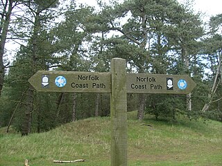
The Norfolk Coast Path is a long-distance footpath in Norfolk, running 83 miles (133.5 km) from Hunstanton to Hopton-on-Sea. It was opened in 1986 and covers the North Norfolk Coast AONB. It is now part of the King Charles III England Coast Path.

Titchwell Marsh is an English nature reserve owned and managed by the Royal Society for the Protection of Birds (RSPB). Located on the north coast of the county of Norfolk, between the villages of Titchwell and Thornham, about 8 km (5.0 mi) east of the seaside resort of Hunstanton, its 171 hectares include reed beds, saltmarshes, a freshwater lagoon and sandy beach, with a small woodland area near the car park. This internationally important reserve is part of the North Norfolk Coast Site of Special Scientific Interest (SSSI) and the Norfolk Coast Area of Outstanding Natural Beauty (AONB), and is also protected through Natura 2000, Special Protection Area (SPA) and Ramsar listings.

Wells-next-the-Sea is a port town on the north coast of Norfolk, England.

Boscastle is a village and fishing port on the north coast of Cornwall, England, in the civil parish of Forrabury and Minster. It is 14 miles (23 km) south of Bude and 5 miles (8 km) northeast of Tintagel. The harbour is a natural inlet protected by two stone harbour walls built in 1584 by Sir Richard Grenville and is the only significant harbour for 20 miles (32 km) along the coast. The village extends up the valleys of the River Valency and River Jordan. Heavy rainfall on 16 August 2004 caused extensive damage to the village.
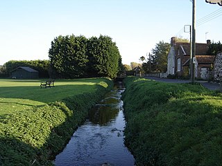
The River Burn is a river in the northwest of the County of Norfolk, in the East of England. From its source to its mouth on the North Coast of Norfolk it is 12.3 kilometres (7.6 mi). The river has a fall of 36 metres to the sea.
Holkham is a small village and civil parish in north Norfolk, England, which includes a stately home and estate, Holkham Hall, and a beach, Holkham Gap, at the centre of Holkham National Nature Reserve.
The Norfolk Burnhams are a group of adjacent villages on the north coast of Norfolk, England. The villages are located near a large natural bay named Brancaster Bay and the Scolt Head Island National Nature Reserve.

Docking is a village and ancient civil parish in the King's Lynn and West Norfolk borough of Norfolk, England. It is near the North Norfolk Coast Site of Special Scientific Interest.

Titchwell is a village and civil parish in Norfolk, England. It is situated on the north Norfolk coast some 1.2 mi (2 km) west of the village of Brancaster, 5.6 mi (9 km) north-east of the seaside resort of Hunstanton, 19 mi (30 km) north of the town of King's Lynn and 43 mi (70 km) north-west of the city of Norwich.

Burnham Overy is a civil parish on the north coast of Norfolk, England. In modern times a distinction is often made between the two settlements of Burnham Overy Town, the original village adjacent to the medieval parish church and now reduced to a handful of houses, and Burnham Overy Staithe, a rather larger hamlet about 1-mile (1.6 km) away and next to the creek-side harbour.

Brancaster Staithe is a village on the north coast of the English county of Norfolk. Brancaster Staithe merges with Burnham Deepdale, forming one village.
Burnham Deepdale is a village and former civil parish, now in the parish of Brancaster, in the English county of Norfolk.
Burnham Norton is a village and civil parish in the English county of Norfolk.

Scolt Head Island is an offshore barrier island between Brancaster and Wells-next-the-Sea in north Norfolk. It is in the parish of Burnham Norton and is accessed by a seasonal ferry from the village of Overy Staithe. The shingle and sand island appears to have originated from a former spit extending from the coast, and longshore drift means that it is slowly moving to the west and inshore.

The A149 is commonly known as "The Coast Road" to local residents and tourists, as this road runs along the North Norfolk coast from King's Lynn to Great Yarmouth, via coastal villages.

Branodunum was an ancient Roman fort to the east of the modern English village of Brancaster in Norfolk.

The North Norfolk Coast Site of Special Scientific Interest (SSSI) is an area of European importance for wildlife in Norfolk, England. It comprises 7,700 ha (19,027 acres) of the county's north coast from just west of Holme-next-the-Sea to Kelling, and is additionally protected through Natura 2000, Special Protection Area (SPA) listings; it is also part of the Norfolk Coast Area of Outstanding Natural Beauty (AONB). The North Norfolk Coast is also designated as a wetland of international importance on the Ramsar list and most of it is a Biosphere Reserve.

Royal West Norfolk Golf Club is a golf club in Brancaster, Norfolk, England, about 7 miles (11 km) east of Hunstanton, between Brancaster Bay and the salt marshes. The links course opened in 1892. Simon Rayner is a professional at the club. The "Royal" club name is named after Edward VII, who was the Prince of Wales at the time of opening.

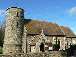
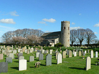
St Mary's Church is a round-tower church in Burnham Deepdale, Norfolk, England. Its round tower and some other parts of the building date from the 11th century. The church underwent additions and rebuilding in the medieval period. It fell into disrepair by the early 18th century, and much of the current building's appearance dates from an 1870 renovation by Frederick Preedy. The church is famed for its many 14th- and 15th-century medieval stained glass windows, and for its Norman font depicting the Labours of the Months.

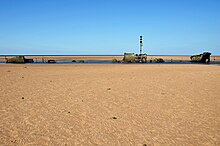
Brancaster Lifeboat Station was located at Brancaster Beach, near the village of Brancaster, on the north coast of the county of Norfolk.