
The Ridgeway is a ridgeway or ancient trackway described as Britain's oldest road. The section clearly identified as an ancient trackway extends from Wiltshire along the chalk ridge of the Berkshire Downs to the River Thames at the Goring Gap, part of the Icknield Way which ran, not always on the ridge, from Salisbury Plain to East Anglia. The route was adapted and extended as a National Trail, created in 1972. The Ridgeway National Trail follows the ancient Ridgeway from Overton Hill, near Avebury, to Streatley, then follows footpaths and parts of the ancient Icknield Way through the Chiltern Hills to Ivinghoe Beacon in Buckinghamshire. The National Trail is 87 miles (140 km) long.
Glyndŵr's Way is a long-distance footpath in mid Wales. It runs for 135 miles (217 km) in an extended loop through Powys between Knighton and Welshpool, and anchored on Machynlleth to the west.
The Norfolk Coast Path is a long-distance footpath in Norfolk, running 83 miles (133.5 km) from Hunstanton to Hopton-on-Sea. It was opened in 1986 and covers the North Norfolk Coast AONB.
The Peddars Way is a long distance footpath that passes through Suffolk and Norfolk, England.
National Trails are long distance footpaths and bridleways in England and Wales. They are administered by Natural England, an agency of the UK government, and Natural Resources Wales, a Welsh government-sponsored body.

The South West Coast Path is England's longest waymarked long-distance footpath and a National Trail. It stretches for 630 miles (1,014 km), running from Minehead in Somerset, along the coasts of Devon and Cornwall, to Poole Harbour in Dorset. Because it rises and falls with every river mouth, it is also one of the more challenging trails. The total height climbed has been calculated to be 114,931 ft (35,031 m), almost four times the height of Mount Everest. It has been voted 'Britain's Best Walking route' twice in a row by readers of The Ramblers' Walk magazine, and regularly features in lists of the world's best walks.

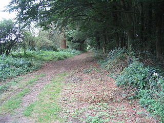
The Icknield Way is an ancient trackway in southern and eastern England that runs from Norfolk to Wiltshire. It follows the chalk escarpment that includes the Berkshire Downs and Chiltern Hills.

The North Downs Way National Trail is a long-distance path in southern England, opened in 1978. It runs from Farnham to Dover, past Guildford, Dorking, Merstham, Otford and Rochester, along the Surrey Hills Area of Outstanding Natural Beauty (AONB) and Kent Downs AONB.
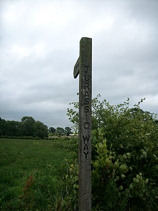
The Jurassic Way is a designated and signed long-distance footpath that connects the Oxfordshire town of Banbury with the Lincolnshire town of Stamford in England. It largely follows an ancient ridgeway traversing Britain; most of its 88-mile (142 km) route is in Northamptonshire on the Jurassic limestone ridge in the north of that county.

The Gritstone Trail, or Cheshire Gritstone Trail, is a 35-mile (56 km) long-distance footpath in England which follows the most westerly hills of the Peak District from Disley Station to Mow Cop, and on via the Macclesfield Canal to Kidsgrove Station. Managed by Cheshire East, the trail involves 5,900 feet (1,800 m) of ascent and is mainly outside the National Park. There are other routes in the Peak District referred to as a "Gritstone Trail" but they are less well established.

Swan's Way is a long distance bridle route and footpath in Northamptonshire, Buckinghamshire and Oxfordshire, England. It runs 65 miles (105 km) from Salcey Forest, Northamptonshire to Goring-On-Thames, Oxfordshire. Although designed for horseriders by riders, it is a multi-use trail also available to walkers and cyclists.

The Wessex Ridgeway is a long-distance footpath in southwest England. It runs 136 miles (219 km) from Marlborough in Wiltshire to Lyme Regis in Dorset, via the northern edge of Salisbury Plain and across Cranborne Chase AONB. The footpath was opened in 1994.

Coney's Castle is an Iron Age hillfort in Dorset, England. The name Coney is from the Old English for rabbit, suggesting medieval use as a domestic warren, as at nearby Pilsdon Pen.
The Iceni Way is a collective name for several long-distance footpaths running from Knettishall Heath to Hunstanton via the Little Ouse and Great Ouse valleys in the English county of Norfolk. There are links with the Fen Rivers Way, Hereward Way, Icknield Way Path, Little Ouse Path and Nar Valley Way. The name comes from the Iceni tribe that once lived in the area.

The Icknield Way Path or Icknield Way Trail is a long distance footpath and riding route in East Anglia, England. The ancient Icknield Way itself is unique among long-distance trails because it can claim to be ‘the oldest road in Britain’. It consists of prehistoric pathways, ancient when the Romans came; the route is dotted with archaeological remains. It survives today in splendid tracks and green lanes along the ‘chalk spine’ of southern England.

The East Devon Way is a long-distance footpath in England. It runs for 38 miles (61 km) between Exmouth in East Devon and Lyme Regis in Dorset.
Ridgeways are a particular type of ancient road that exploits the hard surface of hilltop ridges for use as unpaved, zero-maintenance roads, though they often have the disadvantage of steeper gradients along their courses, and sometimes quite narrow widths. Before the advent of turnpikes or toll roads, ridgeway trails continued to provide the firmest and safest cart tracks. They are generally an opposite to level, valley-bottom, paved roads, which require engineering work to shore up and maintain. Unmaintained valley routes may require greater travelling distances than ridgeways.

The King Charles III England Coast Path (KCIIIECP), originally known as the England Coast Path, is a proposed long-distance National Trail that will follow the coastline of England. When complete, it will be around 2,700 miles (4,300 km) long.

The River Lym or River Lim is a short river, some 5 km in length, that flows through the Devon-Dorset border. It rises from multiple springs at Raymond's Hill, near the village of Uplyme in East Devon, and flows southeasterly through Dorset, into the English Channel via Lyme Bay in the town of Lyme Regis, Dorset. The river falls over 200 metres from its source.

