Headington | |
---|---|
![]() | |
Location within Oxfordshire | |
OS grid reference | SP5407 |
District | |
Shire county | |
Region | |
Country | England |
Sovereign state | United Kingdom |
Post town | Oxford |
Postcode district | OX3 |
Dialling code | 01865 |
Police | Thames Valley |
Fire | Oxfordshire |
Ambulance | South Central |
UK Parliament | |
Website | www.headington.org.uk |
Headington is an eastern suburb of Oxford, in the county of Oxfordshire, England. [1] It is at the top of Headington Hill overlooking the city in the Thames valley below, and bordering Marston to the north-west, Cowley to the south, and Barton and Risinghurst to the east. The life of the large residential area is centred upon London Road, the main road between London and Oxford.
The site of Headington shows evidence of continued occupation from the Stone Age, as the 2001 field excavations in Barton Lane found, suggesting a date in the 11th century BC. Pottery was found on the Manor Ground, suggesting an Iron Age settlement there in the 7th century BC. Roman kilns from about 300 have been found, including one now on display at the Museum of Oxford. Anglo-Saxon burial remains from about 500 have also been discovered. Headington's toponym is derived from the Old English Hedena's dun, meaning "Hedena's hill", when it was the site of a palace or hunting lodge of the Kings of Mercia. In a charter of 1004, Æthelred the Unready, "written at the royal ville called Headan dune", gave land in Headington to St Frideswide's Priory, which included the quarry and the area around it.
Henry I granted a chapel at Headington to the Augustinian canons regular of St Frideswide's Priory, when the priory was founded in 1122. [2] The parish church of Saint Andrew was built in the middle of the 12th century and enlarged in the 13th century. [2] [3] The bell tower was started in the 13th or 14th century [3] and completed in about 1500. [2] St. Andrew's was repaired in the 17th and 18th centuries. [2] The Gothic Revival architect J.C. Buckler restored the building [2] and lengthened the nave in 1862–1864. [2] [3]
Headington developed rapidly in the early 20th century, significant amounts of housing developing around the medieval village, now known as Old Headington, around the original parish church of St Andrew. New Headington refers to some of the area on the south side of the London Road, originating as a late 19th-century suburb. [4] Other neighbourhoods of the modern Headington suburb include Highfield, Quarry, and Headington Hill. [5]
The City of Oxford Silver Band began as the Headington Brass Band having been founded in the 19th century. In 2002 a re-warding of the City created a ward called Headington representing both sides of the London Road, from Bury Knowle Park to Headley Way, with two elected representatives. The first councillors for this ward were David Rundle (2002–2014) and Stephen Tall (2002–2008). Ruth Wilkinson was elected to succeed Stephen Tall in May 2008, and Mohammed Altaf-Khan to succeed David Rundle in 2014.
Headington was an ancient parish in the Bullingdon Hundred of Oxfordshire. [6] In 1868, an area on the western edge of the parish around Headington Hill was included in the Oxford constituency, and in 1889 the same area was added to the city and municipal borough of Oxford. [7] The civil parish of Headington was reduced to just cover the area outside the borough of Oxford in 1894. At the same time, Headington was given a parish council and included in the Headington Rural District. [8]
The parish of Headington was removed from the rural district and converted into an urban district in 1927. It was only an urban district for two years; in 1929 the civil parish and urban district of Headington was abolished. Most of the area was absorbed into Oxford, including the original village. Some of the more rural edges of the old parish were transferred to the neighbouring parishes of Horspath, Forest Hill with Shotover, Elsfield, and Stowood (the latter becoming part of Beckley and Stowood in 1932). [6] [9] [10] In 1921 (the last census before the civil parish was abolished) it had a population of 5,328. [11]
Headington has a large and growing population. [12] Headington's main employment sectors are medicine, education, and research. In the centre of Headington are a number of shops, pubs, cafés, restaurants, and other services. The area also includes the main campus of Oxford Brookes University, Ruskin College (which moved in its entirety from central Oxford to its Headington site in 2012), and the city's main hospitals, including the John Radcliffe, Nuffield and Churchill.
Headington's most famous modern landmark is The Headington Shark, made by John Buckley for local broadcaster Bill Heine in 1986. Headington has a number of green spaces including Headington Hill Park, Bury Knowle park and South Park. Close by is Shotover Hill, a heath and woodland area with views over Oxfordshire, and listed as a Site of Special Scientific Interest. The Warneford Meadow a wild grassland, bought in 1918 by public subscription for the adjacent Warneford Hospital, has been registered as a Town Green and has thus escaped development.
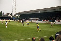
Oxford United were formed as Headington F.C. in 1893, [13] adding the suffix United in 1911 after merging with Headington Quarry. Until 2001 their home ground was the Manor Ground, which had its main entrance on London Road. [14] In 2001 Oxford United moved to the Kassam Stadium near Blackbird Leys. [15] The Manor Ground has since been demolished and a private hospital built on the site. [16] Headington has a non-league football team, Headington Amateurs, who play at the Barton Recreation Ground.
A number of Oxford academics have lived in Headington over the years. They include Lord Krebs, David Marquand, Anthony Kenny, Sir Isaiah Berlin, the historian A. B. Emden, the chemist Dalziel Hammick, Lord Elton, Michael Ernest Sadler, Cyril Bailey, his daughter Mary Creighton Bailey who was born there, and John Johnson (the University Printer). Others included the author Elizabeth Bowen, Robert Maxwell and his daughter Ghislaine Maxwell, Lord Nuffield (William Morris), and Anne Diamond, the television presenter and author.
Bicester is a market town and civil parish in the Cherwell district of northeastern Oxfordshire in south-central England. The town also comprises an eco-town development at North West Bicester and a self-build village at Graven Hill. Its local market is located on Sheep Street, a pedestrian zone in the conservation area of the town. Bicester is also known for the Bicester Village shopping centre.
Marston is a village in the civil parish of Old Marston about 2 miles (3 km) northeast of the centre of Oxford, England. It was absorbed within the city boundaries in 1991. It is commonly called Old Marston to distinguish it from the suburb of New Marston that developed between St. Clement's and the village in the 19th and 20th centuries. The A40 Northern Bypass, part of the Oxford Ring Road forms a long north-west boundary of the village and parish and a limb, namely a distributary, of the Cherwell forms the western boundary.
Shotover is a hill and forest in the civil parish of Forest Hill with Shotover, in the South Oxfordshire district, in the county of Oxfordshire, England. The hill is 3 miles (4.8 km) east of Oxford. Its highest point is 557 feet (170 m) above sea level.
Oxford East is a constituency represented in the House of Commons of the UK Parliament since 2017 by Anneliese Dodds of the Labour Party, who also serves as party chair.
Ambrosden is a village and civil parish in Cherwell, Oxfordshire, England, 3 miles (5 km) southwest of Bicester to which it is linked by the A41 road, and 13 miles (21 km) from Oxford. The 2011 Census recorded the parish's population as 2,248. The parish is bounded by the River Ray to the south, its tributary the River Bure to the west, the outskirts of Bicester to the north and field boundaries to the east.
Risinghurst is a suburb of Oxford, England 3 miles (4.8 km) east of the city centre, just outside the Oxford Ring Road. It is near to Headington, Barton and Wood Farm. It was built during the interwar period to relieve the housing shortage from working-class people moving to cities, in this case to take advantage of the motor industry in Oxford.
Wheatley is a village and civil parish in South Oxfordshire, England, about 5 miles (8 km) east of Oxford. The parish includes the hamlet of Littleworth, which is west of Wheatley.
Arncott or Arncot is a village and civil parish about 3+1⁄2 miles (5.6 km) southeast of Bicester in Oxfordshire. The 2011 Census recorded the parish's population as 1,738.
Bullingdon Rural District was a rural district in Oxfordshire, England from 1932 to 1974, covering an area to the south-east of the city of Oxford.
St Clement's is a district in Oxford, England, on the east bank of the River Cherwell. "St Clement's" is usually taken to describe a small triangular area from The Plain bounded by the River Cherwell to the North, Cowley Road to the South, and the foot of Headington Hill to the East. It also refers to the ecclesiastical parish of St Clement's which includes some neighbouring areas and is used in the names of local City and County electoral districts.
Bullingdon was a hundred in the county of Oxfordshire, covering an area to the east of Oxford. It took its name from the hamlet of Bullingdon Green, in the parish of Horspath, where the hundred court originally met.
Barton is a village and suburb of Oxford, in Oxfordshire, England. It is 3 miles east of the centre of Oxford, just outside the Oxford Ring Road. It is near to Headington, Risinghurst and Marston.
Horspath is a village and civil parish in South Oxfordshire about 3+1⁄2 miles (5.6 km) east of the centre of Oxford, England. The 2011 census recorded the parish's population as 1,378.
Piddington is a village and civil parish about 4.5 miles (7 km) southeast of Bicester in Oxfordshire, England. It lies close to the border with Buckinghamshire. Its toponym has been attributed to the Old English Pyda's tun. The 2011 Census recorded the parish's population as 370.
Forest Hill is a village in the civil parish of Forest Hill with Shotover, in the South Oxfordshire district, in Oxfordshire, England, about 4.5 miles (7 km) east of Oxford. The village which is about 330 feet (100 m) above sea level is on the northeastern brow of a ridge of hills. The highest point of the ridge is Red Hill, which rises to 440 feet (130 m) just south of the village. The 2011 Census recorded Forest Hill with Shotover's population as 856.
Headington Quarry is a suburb and civil parish of Oxford, England. Once a separate village built on the site of a former limestone quarry, it is now fully integrated into the city of Oxford and lies approximately 3 miles east of the city centre, just inside the Oxford Ring Road. It is near to Headington, Wood Farm, Risinghurst, and Barton.
Forest Hill with Shotover is a civil parish covering 7.56 km2 of South Oxfordshire approximately centred 3 miles (4.8 km) east of Oxford. Its population in 2011 was 856, almost exclusively in the villages of Forest Hill, hamlets of Shotover Cleve and Shotover Edge. It includes a country estate at Shotover Park. Forest Hill with Shotover was formed in 1881 by the merger of three smaller civil parishes: Forest Hill, Shotover and Shotover Hill Place.
Holton is a village and civil parish in South Oxfordshire about 5.5 miles (9 km) east of Oxford. The parish is bounded to the southeast by the River Thame, to the east and north by the Thame's tributary Holton Brook, to the south by London Road and to the west by field boundaries with the parishes of Forest Hill with Shotover and Stanton St John.
Old Road is a long street in Headington, east Oxford, England, extending into Oxfordshire as a road east of Oxford, to Littleworth near Wheatley. It is part of the main old road between Oxford and London until the late 18th century, passing over Shotover Hill. Nowadays it crosses the Oxford Ring Road (A4142) with a bridge.