
Risinghurst and Sandhills is a civil parish to the eastern edge of Oxford, England, just outside the Oxford Ring Road. According to the 2011 census, it had a population of 4,237. It borders Barton, Headington Quarry and Wood Farm.
Risinghurst and Sandhills is a civil parish to the eastern edge of Oxford, England, just outside the Oxford Ring Road. According to the 2011 census, it had a population of 4,237. It borders Barton, Headington Quarry and Wood Farm.
The City of Oxford | ||
|---|---|---|
| Wards, suburbs, neighbourhoods and districts |
| 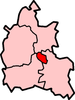 |
| Civil parishes | ||
| Former district and borough | ||
| Former constituencies | ||
51°45′45″N1°11′20″W / 51.76250°N 1.18889°W
| | This Oxfordshire location article is a stub. You can help Wikipedia by expanding it. |

Oxfordshire is a ceremonial county in South East England. The county is bordered by Northamptonshire and Warwickshire to the north, Buckinghamshire to the east, Berkshire to the south, and Wiltshire and Gloucestershire to the west. The city of Oxford is the largest settlement and county town.

A sandhill is a type of ecological community or xeric wildfire-maintained ecosystem. It is not the same as a sand dune. It features very short fire return intervals, one to five years. Without fire, sandhills undergo ecological succession and become more oak dominated.

Oxford East is a constituency represented in the House of Commons of the UK Parliament by Anneliese Dodds of the Labour Party, who also serves as party chair.

Bath is an unincorporated community in the northern part of Bath Township, Summit County, Ohio, United States. It is centered at the intersection of Cleveland-Massillon and Ira roads. It was developed 'circa 1820.

Headington is an eastern suburb of Oxford, in the county of Oxfordshire, England. It is at the top of Headington Hill overlooking the city in the Thames valley below, and bordering Marston to the north-west, Cowley to the south, and Barton and Risinghurst to the east. The life of the large residential area is centred upon London Road, the main road between London and Oxford.
Risinghurst is a suburb of Oxford, England 3 miles (4.8 km) east of the city centre, just outside the Oxford Ring Road. It is near to Headington, Barton and Wood Farm. It was built during the interwar period to relieve the housing shortage from working-class people moving to cities, in this case to take advantage of the motor industry in Oxford.
Wilder Park is a neighborhood four miles south of downtown Louisville, Kentucky USA. The area was originally the site of Greenland race course, built in 1866, a sister track of Churchill Downs. Greenland track closed in 1888 and the area became the Wilder Park neighborhood.

Beckley and Stowood is a civil parish in South Oxfordshire, England. Its area is 9.17 km2. It is 3 miles (4.8 km) northeast of Oxford and 1 mile (1.6 km) west of the M40. The parish is made up of Beckley and Stowood.
Blenheim is a civil parish in West Oxfordshire, England, about 7 miles (11 km) north of Oxford. At its edge is Blenheim Palace, which is the birthplace of Sir Winston Churchill and the ancestral home of the Dukes of Marlborough.

Barton is a suburb of Oxford, England 2.8 miles (5 km) east of the city centre, just outside the Oxford Ring Road. It is near to Headington, Risinghurst and Marston.
Gosford and Water Eaton is a civil parish in the Cherwell district of the county of Oxfordshire, England. It is north of the city of Oxford and is crossed nearby by two major roads for, or by-passing, the city. The parish contains the village of Gosford and the hamlet of Water Eaton and as at the 2011 census had 1373 people resident across its 8.75 km2.

Herne power plant is a coal-fired power plant located at Herne in North Rhine-Westphalia, Germany. It was constructed in 1962. The installed capacity of the plant is 950 megawatts. The power plant is owned and operated by Evonik Steag GmbH, a subsidiary of Evonik Industries.

Ellison Township is located in Warren County, Illinois, United States. As of the 2010 census, its population was 337 and it contained 140 housing units.

Malta Parish is an administrative unit of Rēzekne Municipality, Latvia.
Ellingham, Harbridge and Ibsley is a civil parish in the west of the English county of Hampshire. The population of the civil parish at the 2011 Census was 1,171.
Shipton-on-Cherwell Halt was a railway halt constructed in 1929 by the Great Western Railway to serve the Oxfordshire village of Shipton-on-Cherwell as well as the adjacent Oxford and Shipton Cement Company limestone quarry and cement works.
Forest Hill with Shotover is a civil parish covering 7.56 km2 of South Oxfordshire approximately centred 3 miles (4.8 km) east of Oxford. Its population in 2011 was 856, almost exclusively in the villages of Forest Hill, hamlets of Shotover Cleve and Shotover Edge. It includes a country estate at Shotover Park. Forest Hill with Shotover was formed in 1881 by the merger of three smaller civil parishes: Forest Hill, Shotover and Shotover Hill Place.

Qernertunnguit is a neighborhood of Nuuk, the capital of Greenland. It is part of the Quassussuup Tungaa district, located in the northwestern part of the town, facing the Nuup Kangerlua fjord.
Julia Gasper is an English independent academic specialising in early modern literature, and a right-wing political activist affiliated with the English Democrats. She formerly belonged to the UK Independence Party (UKIP). A vociferous critic of LGBT rights, she has generated controversy with comments widely deemed homophobic and transphobic.

CS Lewis Nature Reserve is a 3-hectare (7.4-acre) nature reserve in Risinghurst, a suburb of Oxford in Oxfordshire. It is managed by the Berkshire, Buckinghamshire and Oxfordshire Wildlife Trust.