
Hampshire is a ceremonial county in South East England. It is bordered by Berkshire to the north, Surrey and West Sussex to the east, the Isle of Wight across the Solent to the south, Dorset to the west, and Wiltshire to the north-west. The city of Southampton is the largest settlement.

Winchester is a cathedral city in Hampshire, England. The city lies at the heart of the wider City of Winchester, a local government district, at the western end of the South Downs National Park, on the River Itchen. It is 60 miles (97 km) south-west of London and 14 miles (23 km) from Southampton, its nearest city. At the 2021 census, the built-up area of Winchester had a population of 48,478. The wider City of Winchester district includes towns such as Alresford and Bishop's Waltham and had a population of 127,439 in 2021. Winchester is the county town of Hampshire and contains the head offices of Hampshire County Council.

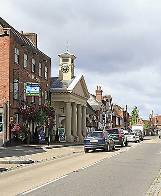
Romsey is a town in the Test Valley district of Hampshire, England. The town is situated 7 miles (11 km) northwest of Southampton, 11 miles (18 km) southwest of Winchester and 17 miles (27 km) southeast of Salisbury. It sits on the outskirts of the New Forest, just over 3 miles (4.8 km) northeast of its eastern edge. The population of Romsey was 14,768 at the 2011 census.

Castlefield is an inner-city conservation area in Manchester, North West England. The conservation area which bears its name is bounded by the River Irwell, Quay Street, Deansgate and Chester Road. It was the site of the Roman era fort of Mamucium or Mancunium which gave its name to Manchester. It was the terminus of the Bridgewater Canal, the world's first industrial canal, built in 1764; the oldest canal warehouse opened in 1779. The world's first passenger railway terminated here in 1830, at Liverpool Road railway station and the first railway warehouse opened here in 1831.

The River Itchen in Hampshire, England, rises to the south of New Alresford and flows 26 miles (42 km) to meet Southampton Water below the Itchen Bridge. The Itchen Navigation was constructed in the late 17th and early 18th centuries to enable barges to reach Winchester from Southampton Docks, but ceased to operate in the mid-19th century and is largely abandoned today.
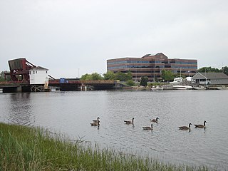
The Neponset River is a river in eastern Massachusetts in the United States. Its headwaters are at the Neponset Reservoir in Foxborough, near Gillette Stadium. From there, the Neponset meanders generally northeast for about 29 miles (47 km) to its mouth at Dorchester Bay between Quincy and the Dorchester section of Boston, near the painted gas tank.
Botley is a historic village in Hampshire, England, approximately 3 miles (4.8 km) east of Southampton. It was developed as a natural crossing point for the River Hamble, and received its first market charter from Henry III in 1267. The village grew on the success of its mills, its coaching inns, and more recently strawberries, and was described as "the most delightful village in the world" by 18th century journalist and radical politician William Cobbett.

The River Loddon is a tributary of the River Thames in southern England. It rises at Basingstoke in Hampshire and flows northwards for 28 miles (45 km) to meet the Thames at Wargrave in Berkshire. Together, the Loddon and its tributaries drain an area of 400 square miles (1,036 km2).

Houghton Mill is a water mill located on the Great Ouse in the village of Houghton, Cambridgeshire, England. It is a National Trust property and a Grade II* listed building.

A tide mill is a water mill driven by tidal rise and fall. A dam with a sluice is created across a suitable tidal inlet, or a section of river estuary is made into a reservoir. As the tide comes in, it enters the mill pond through a one-way gate, and this gate closes automatically when the tide begins to fall. When the tide is low enough, the stored water can be released to turn a water wheel.

Bursledon Windmill is a Grade II* listed windmill in Bursledon, Hampshire, England which has been restored to working order.

The River Poddle is a river in Dublin, Ireland, a pool of which gave the city its English language name. Boosted by a channel made by the Abbey of St. Thomas à Becket, taking water from the far larger River Dodder, the Poddle was the main source of drinking water for the city for more than 500 years, from the 1240s. The Poddle, which flows wholly within the traditional County Dublin, is one of around a hundred members of the River Liffey system, and one of over 135 watercourses in the county; it has just one significant natural tributary, the Commons Water from Crumlin.

The River Wey Navigation and Godalming Navigation together provide a 20-mile (32 km) continuous navigable route from the River Thames near Weybridge via Guildford to Godalming. Both waterways are in Surrey and are owned by the National Trust. The River Wey Navigation connects to the Basingstoke Canal at West Byfleet, and the Godalming Navigation to the Wey and Arun Canal near Shalford. The navigations consist of both man-made canal cuts and adapted parts of the River Wey.

The Wendover Arm Canal is part of the Grand Union Canal in England, and forms part of the British canal system. It is usually known as the Wendover Canal, but historically its builders referred to their branch canals as Arms, hence its historical name of Wendover Arm. It was planned as a feeder to carry water from springs near the town of Wendover in Buckinghamshire to the main line of the Grand Junction Canal at Bulbourne near Startops End in Hertfordshire, but when it opened in 1799 it was made navigable, as the extra cost of making it was so small. Water supplies from Wendover were found to be inadequate, and a series of reservoirs were built. A pumping station at Whitehouses was superseded by the Tringford pumping station in 1817; its steam engines were replaced by diesel engines in 1911 and then by electric pumps.
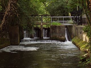
The Itchen Navigation is a 10.4-mile (16.7 km) disused canal system in Hampshire, England, that provided an important trading route from Winchester to the sea at Southampton for about 150 years. Improvements to the River Itchen were authorised by act of parliament in 1665, but progress was slow, and the navigation was not declared complete until 1710. It was known as a navigation because it was essentially an improved river, with the main river channel being used for some sections, and cuts with locks used to bypass the difficult sections. Its waters are fed from the River Itchen. It provided an important method of moving goods, particularly agricultural produce and coal, between the two cities and the intervening villages.

Oldland Windmill is an 18th-century post mill situated near the village of Keymer, West Sussex, England. It is a Grade II Listed Building.

Crux Easton wind engine is a Grade II listed Titt wind engine, used as a windpump, at Crux Easton, Hampshire, England, which has been restored to working order.

The Land Yeo is a small river which flows through North Somerset, England. It rises on Dundry Hill and supplies Barrow Gurney Reservoirs before flowing through various villages to Clevedon where it drains into the Severn Estuary. During the past 1,000 years it has powered at least ten watermills; however, only one is still functional. Since 2003 initiatives have been undertaken to clean up the river, improving water quality and encouraging wildlife.

Itchen Stoke and Ovington is an English civil parish consisting of two adjoining villages in Hampshire, England, 2 miles (3.2 km) west of Alresford town centre in the valley of the River Itchen, 5 miles (8.0 km) north-east of Winchester, and 2 miles (3.2 km) south-east of Itchen Abbas.

Coultershaw Bridge is a rural community situated 1.5 mi (2.4 km) south of the town Petworth in West Sussex, England where the A285 road from Petworth to Chichester crosses the River Rother.

