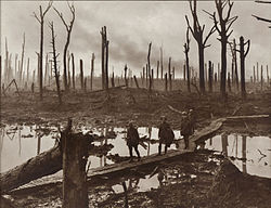
A boardwalk (alternatively board walk, boarded path, or promenade ) is an elevated footpath, walkway, or causeway typically built with wooden planks, which functions as a type of low water bridge or small viaduct that enables pedestrians to better cross wet, muddy or marshy lands. [1] Such timber trackways have existed since at least Neolithic times.
Some wooden boardwalks have had sections replaced by concrete and even "a type of recycled plastic that looks like wood." [2]
An early example is the Sweet Track that Neolithic people built in the Somerset levels, England, around 6000 years ago. [3] This track consisted mainly of planks of oak laid end-to-end, supported by crossed pegs of ash, oak, and lime, driven into the underlying peat. [4]
The Wittmoor bog trackway is the name given to each of two prehistoric plank roads, or boardwalks, trackway No. I being discovered in 1898 and trackway No. II in 1904 [5] in the Wittmoor bog in northern Hamburg, Germany. The trackways date to the 4th and 7th century AD, both linked the eastern and western shores of the formerly inaccessible, swampy bog. A part of the older trackway No. II dating to the period of the Roman Empire is on display at the permanent exhibition of the Archaeological Museum Hamburg in Harburg borough, Hamburg. [6] [7]
A duckboard is a type of boardwalk placed over muddy and wet ground. [8] During World War I, duckboards were used to line the bottom of trenches on the Western Front because these were regularly flooded, [9] and mud and water would lie in the trenches for months on end. The boards helped to keep the soldiers' feet dry and prevent the development of trench foot, caused by prolonged standing in waterlogged conditions. They also allowed for troops' easier movement through the trench systems. [9]
Combat troops on nearly all sides routinely wore hobnail-style trench boots that often slipped on the new duck boards when they were wet, and required extra caution. Falling or slipping off the duckboards could often be dangerous, even fatal. Unfortunate soldiers were left struggling to rise under the weight of their equipment in the intractable and sometimes deep water or mud. If this happened at ground level during a tactical advance, the rising soldier could be left a defenseless target for enemy fire as well as hinder forward progress. He could also simply go unnoticed in the ensuing melee, and easily drown under his heavy equipment. [10] [11]
The Somerset Levels are a coastal plain and wetland area of Somerset, England, running south from the Mendips to the Blackdown Hills.
Flag Fen, east of Peterborough, England, is a Bronze Age site which was constructed about 3500 years ago and consists of more than 60,000 timbers arranged in five very long rows, creating a wooden causeway across the wet fenland. Part-way across the structure a small island was formed. Items associated with it have led scholars to conclude that the island was of religious significance. Archaeological work began in 1982 at the site, which is located 800 m east of Fengate. Flag Fen is now part of the Greater Fens Museum Partnership. A visitor centre has been constructed on site and some areas have been reconstructed, including a typical Iron Age roundhouse dwelling.
A plank road is a road composed of wooden planks or puncheon logs, as an efficient technology for traversing soft, marshy, or otherwise difficult ground. Plank roads were commonly found in the Canadian province of Ontario as well as the Northeast and Midwest of the United States in the first half of the 19th century. They were often built by turnpike companies.
The Sweet Track is an ancient trackway, or causeway, in the Somerset Levels, England, named after its finder, Ray Sweet. It was built in 3807 BC and is the second-oldest timber trackway discovered in the British Isles, dating to the Neolithic. The Sweet Track was predominantly built along the course of an earlier structure, the Post Track.
A footbridge is a bridge designed solely for pedestrians. While the primary meaning for a bridge is a structure which links "two points at a height above the ground", a footbridge can also be a lower structure, such as a boardwalk, that enables pedestrians to cross wet, fragile, or marshy land. Bridges range from stepping stones–possibly the earliest man-made structure to "bridge" water–to elaborate steel structures. Another early bridge would have been simply a fallen tree. In some cases a footbridge can be both functional and artistic.
Historic roads are paths or routes that have historical importance due to their use over a period of time. Examples exist from prehistoric times until the early 20th century. They include ancient trackways, long-lasting roads, important trade routes, and migration trails. Many historic routes, such as the Silk Road, the Amber Road, and the Royal Road of the Persian Empire, covered great distances and their impact on human settlements remain today.
Westhay Moor is a 513.7-hectare (1,269-acre) biological Site of Special Scientific Interest 2.5 kilometres (1.6 mi) north-east of Westhay village and 4 kilometres (2.5 mi) from Wedmore in Somerset, England, notified in 1971. Westhay Moor is also notified as part of the Somerset Levels and Moors Special Protection Area under the EU Birds Directive and as a Ramsar site, and a National Nature Reserve.
The Corlea Trackway is an Iron Age trackway, or togher, near the village of Keenagh, south of Longford, County Longford, in Ireland. It was known locally as the Danes' Road. It was constructed from oak planks in 148–147 BC, making it contemporary with the Siege of Carthage.
Hatfield Moors is a 1400.7 hectare biological site of Special Scientific Interest in South Yorkshire. The site was notified in 1954. The site is managed by Natural England.
The Archäologisches Museum Hamburg is an archaeological museum in the Harburg borough of Hamburg, Germany. It houses the archaeological finds of the city of Hamburg and the neighbouring counties to the south of the city. It focuses on northern German prehistory and early history as well as the history of the former city of Harburg. The museum is also home to the cultural heritage landmarks commission of the city of Hamburg and the adjacent district of Harburg in Lower-Saxony and thus supervises all archaeological undertakings in the region.
In archaeology, waterlogging refers to the long-term exclusion of air by groundwater, which creates an anaerobic environment that can preserve artifacts perfectly. Such waterlogging preserves perishable artifacts. Thus, in a site which has been waterlogged since the archaeological horizon was deposited, exceptional insight may be obtained by study of artifacts made of leather, wood, textile or similar materials. 75-90% of the archaeological remains at wetland sites are found to be organic material. Tree rings found from logs that have been preserved allow archaeologists to accurately date sites. Wetland sites include all those found in lakes, swamps, marshes, fens, and peat bogs.
The Post Track is an ancient causeway in the valley of the River Brue on the Somerset Levels, England. It dates from around 3838 BCE, making it some 30 years older than the Sweet Track in the same area. Various sections have been scheduled as ancient monuments.
Meare Lake Village is the site of an Iron Age settlement on the Somerset Levels at Meare, Somerset, England. It is a Scheduled Ancient Monument.
The Wittmoor bog trackway is the name given to each of two historic corduroy roads, trackway No. I being discovered in 1898 and trackway No. II in 1904 in the Wittmoor bog in northern Hamburg, Germany. The trackways date to the 4th and 7th century AD, both linked the eastern and western shores of the formerly inaccessible, swampy bog. A part of the older trackway No. II dating to the period of the Roman Empire is on display at the permanent exhibition of the Archaeological Museum Hamburg in Harburg, Hamburg.
Anthropomorphic wooden cult figurines, sometimes called pole gods, have been found at many archaeological sites in Central and Northern Europe. They are generally interpreted as cult images, in some cases presumably depicting deities, sometimes with either a votive or an apotropaic (protective) function. Many have been preserved in peat bogs. The majority are more or less crudely worked poles or forked sticks; some take the form of carved planks. They have been dated to periods from the Mesolithic to the Early Middle Ages, including the Roman Era and the Migration Age. The majority have been found in areas of Germanic settlement, but some are from areas of Celtic settlement and from the later part of the date range, Slavic settlement. A typology has been developed based on the large number found at Oberdorla, Thuringia, at a sacrificial bog which is now the Opfermoor Vogtei open-air museum.
There are over 670 scheduled monuments in the ceremonial county of Somerset in South West England. The county consists of a non-metropolitan county, administered by Somerset Council. The two administratively independent unitary authorities, which were established on 1 April 1996 following the breakup of the county of Avon, are North Somerset and Bath and North East Somerset. These unitary authorities include areas that were once part of Somerset before the creation of Avon in 1974.
The archaeology of Hatfield and Thorne moors has been investigated over the last 40 years and includes significant finds of Bronze Age and Neolithic trackways.
The Hatfield Neolithic Trackway was discovered in 2004, and is one of the oldest known ancient timber trackways in England. The trackway is the second confirmed archaeological structure from Hatfield and Thorne Moors. The Lindholme Trackway dates to around 2900–2500 BC.
Durankulak is a prehistoric archaeological site on the Golemija ostrov in Durankulak lake, Bulgaria. Prehistoric settlement commenced on the small island approximately 7000 BP and lasted for thousands of years.
{{cite book}}
: CS1 maint: location missing publisher (link)