River Medina

Last updated

River Medina
Newport-cowes wb.jpg
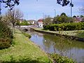
The Medina estuary showing Newport and Cowes.
Physical characteristics
Source 
  locationSt Catherine's Down
Mouth  
  location
Solent
Length17 km (11 mi)

The River Medina is the main river of the Isle of Wight, England, rising at St Catherine's Down near Chale, and flowing northwards through the county town Newport, towards the Solent at Cowes. The river is a navigable tidal estuary from Newport northwards, where it takes the form of a ria (a drowned valley). This occurred because the Medina used to be a tributary of what was once the "River Solent", with a larger catchment area. As the Solent valley flooded, the river received less water and more sediment, causing it to become more tidal.

Contents

The river is bridged at Newport. Cowes is connected to East Cowes by a chain ferry known as the Cowes Floating Bridge. [1] The river also has several small ferries which cater mainly for sailors.

The name Medina comes from the Old English Meðune meaning "the middle one", and the current pronunciation was first recorded as 'Medine' in 1196. [2] The river's only named tributary is Lukely Brook. The navigation of the river was improved in the nineteenth century by Henry Daniel Martin, a civil engineer who lived in Newport. [3]

The river is used by yachtsmen as a safe harbour. Along its banks there are old warehouses and wharves, where in the past flying boats, hovercraft and steam ships were developed and built. The Classic Boat Museum displays much of the river's history, as well as the history of yachting. The Island Harbour Marina, at the site of an old tidal mill, is on the river about two miles from Newport.

Views along the river

See also

Related Research Articles

<span class="mw-page-title-main">The Solent</span> Strait separating the Isle of Wight from the mainland of England

The Solent is a strait between the Isle of Wight and Great Britain. It is about 20 miles long and varies in width between 2+12 and 5 mi, although the Hurst Spit which projects 1+12 mi (2.4 km) into the Solent narrows the sea crossing between Hurst Castle and Colwell Bay to just over 1 mi (1.6 km).

<span class="mw-page-title-main">River Severn</span> River in the United Kingdom

The River Severn, at 220 miles (354 km) long, is the longest river in Great Britain. It is also the river with the most voluminous flow of water by far in all of England and Wales, with an average flow rate of 107 m3/s (3,800 cu ft/s) at Apperley, Gloucestershire. It rises in the Cambrian Mountains in mid Wales, at an altitude of 2,001 feet (610 m), on the Plynlimon massif, which lies close to the Ceredigion/Powys border near Llanidloes. The river then flows through Shropshire, Worcestershire and Gloucestershire. The county towns of Shrewsbury and Gloucester and the City of Worcester lie on its course.

<span class="mw-page-title-main">River Hamble</span> River in south Hampshire, England

The River Hamble is located in south Hampshire, England. It rises near Bishop's Waltham and flows for 10.1 km (6.3 mi) through Botley, Bursledon, and Lower Swanwick before entering Southampton Water between Hamble Common and Warsash.

<span class="mw-page-title-main">River Mersey</span> Major river emptying into Liverpool Bay

The River Mersey is in North West England. Its name derives from Old English and means "boundary river", possibly referring to its having been a border between the ancient kingdoms of Mercia and Northumbria. For centuries it has formed part of the boundary between the historic counties of Lancashire and Cheshire.

<span class="mw-page-title-main">River Usk</span> River in Wales

The River Usk rises on the northern slopes of the Black Mountain, Wales, in the westernmost part of the Brecon Beacons National Park. Initially forming the boundary between Carmarthenshire and Powys, it flows north into Usk Reservoir, then east by Sennybridge to Brecon before turning southeast to flow by Talybont-on-Usk, Crickhowell and Abergavenny after which it takes a more southerly course.

<span class="mw-page-title-main">River Tamar</span> River in southwest England

The Tamar is a river in south west England, that forms most of the border between Devon and Cornwall. A part of the Tamar Valley is a World Heritage Site due to its historic mining activities.

<span class="mw-page-title-main">Poole Harbour</span> Natural harbour in England

Poole Harbour is a large natural harbour in Dorset, southern England, with the town of Poole on its shores. The harbour is a drowned valley (ria) formed at the end of the last ice age and is the estuary of several rivers, the largest being the Frome. The harbour has a long history of human settlement stretching to pre-Roman times. The harbour is extremely shallow, with one main dredged channel through the harbour, from the mouth to Holes Bay.

<span class="mw-page-title-main">Newport, Isle of Wight</span> English county town

Newport is the county town of the Isle of Wight, an island county off the south coast of England. The town is slightly north of the centre of the island, and is in the civil parish of Newport and Carisbrooke. It has a quay at the head of the navigable section of the River Medina, which flows northwards to Cowes and the Solent. In 2020 it had an estimated population of 26,109.

<span class="mw-page-title-main">Cowes</span> Town in Isle of Wight, England

Cowes is an English seaport town and civil parish on the Isle of Wight. Cowes is located on the west bank of the estuary of the River Medina, facing the smaller town of East Cowes on the east bank. The two towns are linked by the Cowes Floating Bridge, a chain ferry.

<span class="mw-page-title-main">River Camel</span> River in Cornwall, England

The River Camel is a river in Cornwall, England. It rises on the edge of Bodmin Moor and with its tributaries its catchment area covers much of North Cornwall. The river flows into the eastern Celtic Sea between Stepper Point and Pentire Point having covered about 30 miles, making it the second longest river wholly in Cornwall. The river is tidal upstream to Egloshayle and is popular for sailing, birdwatching and fishing. The name Camel comes from the Cornish language for 'the crooked one', a reference to its winding course. Historically the river was divided into three named stretches. Heyl was the name for the estuary up to Egloshayle, the River Allen was the stretch between Egloshayle and Trecarne, whilst the Camel was reserved for the stretch of river between its source and Trecarne.

<span class="mw-page-title-main">Southampton Water</span> Tidal estuary in England

Southampton Water is a tidal estuary north of the Solent and the Isle of Wight in England. The city of Southampton lies at its most northerly point, where the estuaries of the River Test and River Itchen meet. Along its salt marsh-fringed western shores lie the New Forest villages of Dibden, Hythe and Fawley, and the Fawley Refinery. On the slightly steeper eastern shore are the Southampton suburb of Weston, the villages of Netley and Hamble-le-Rice, and the Royal Victoria Country Park. To the south, Southampton Water enters the Solent between Calshot Spit and Hill Head.

<span class="mw-page-title-main">River Itchen, Hampshire</span> River in Hampshire, England

The River Itchen in Hampshire, England, rises to the south of New Alresford and flows 26 miles (42 km) to meet Southampton Water below the Itchen Bridge. The Itchen Navigation was constructed in the late 17th and early 18th centuries to enable barges to reach Winchester from Southampton Docks, but ceased to operate in the mid-19th century and is largely abandoned today.

<span class="mw-page-title-main">East Cowes</span> Human settlement in England

East Cowes is a town and civil parish in the north of the Isle of Wight, on the east bank of the River Medina, next to its west bank neighbour Cowes.

<span class="mw-page-title-main">River Lynher</span> River in east Cornwall, England

The River Lynher flows through east Cornwall, England, and enters the River Tamar at the Hamoaze, which in turn flows into Plymouth Sound.

<span class="mw-page-title-main">Wootton Creek</span> Tidal estuary of the Isle of Wight, England

Wootton Creek is a tidal estuary that flows into the Solent on the north coast of the Isle of Wight. The estuary has also been known in the past as "Fishbourne Creek", "Wootton River" and "Wootton Haven".

<span class="mw-page-title-main">River Blyth, Suffolk</span> River in east Suffolk, England

The River Blyth is a river in east Suffolk, England. Its source is near Laxfield and it reaches a tidal estuary between Southwold and Walberswick on the North Sea coast.

<span class="mw-page-title-main">River Crouch</span> River in Essex, England

The River Crouch is a small river that flows entirely through the English county of Essex.

Cowes Floating Bridge

The Cowes Floating Bridge is a vehicular chain ferry which crosses the River Medina on the Isle of Wight, off the south coast of England. The ferry crosses the tidal river from East Cowes to Cowes. The first floating bridge between the two towns was established in 1859 and the crossing is one of the few remaining that has not been replaced by a physical bridge. The service is owned and operated by the Isle of Wight Council, which has run it since 1901. Prior to ownership by the local authority the service was run by The Floating Bridge Company and The Steam Packet Company. The ferry currently used is named No. 6, the sixth to be owned by the Isle of Wight Council, and ninth in total. It was built in 2017 and can carry up to 20 cars. The Cowes floating bridge remains the only way to cross the River Medina between the towns without taking a ten-mile trip via Newport. The current vessel was installed on 14 May 2017, but after a string of technical issues the service was suspended by the Maritime and Coastguard Agency, and a passenger-only replacement service provided by a small launch. After several months of service suspension and intermittent operation, full service finally resumed early in 2018.

<span class="mw-page-title-main">Port of Southampton</span> Passenger and cargo port in Southampton, England

The Port of Southampton is a passenger and cargo port in the central part of the south coast of England. The modern era in the history of the Port of Southampton began when the first dock was inaugurated in 1843. The port has been owned and operated by Associated British Ports since 1982, and is the busiest cruise terminal and second largest container port in the UK. The volume of port traffic categorises Southampton as a Medium-Port City globally.

National Cycle Route 23 is a route of the National Cycle Network, running from Reading to Sandown. The partially signed route passes through Basingstoke, Eastleigh and Southampton; once across the Solent, it continues through Cowes and Newport.

References

  1. "IWight - Cowes Chain Ferry Homepage". www.iwight.gov.uk. Archived from the original on 5 October 2008. Retrieved 30 September 2008.
  2. Popular Dictionary of English Place-Names, OUP, Mills A D (1991)
  3. "Henry Daniel Martin". Grace's Guide to British Industrial History. Grace's Guide. Retrieved 23 October 2020.