
Cissbury Ring is an 84.2-hectare (208-acre) biological Site of Special Scientific Interest north of Worthing in West Sussex. It is owned by the National Trust and is designated a Scheduled monument for its Neolithic flint mine and Iron Age hillfort.

St Boniface Down is a chalk down near Ventnor, on the Isle of Wight, England. Its summit, 241 metres (791 ft), is the highest point on the island, with views stretching from Beachy Head to the east, Portsmouth to the north and the Isle of Portland to the west. It is 1 kilometre (0.6 mi) north of the town. There is reputed to be a wishing well on its southern slope, which requires the wisher to climb up from the south without looking back. In 1545, a French invasion force attempted this against a force of the Isle of Wight Militia commanded by Sir John Fyssher – which allegedly included several women archers- and were routed. In 1940, the radar station was bombed by Ju 87 Stuka dive bombers, which is reconstructed in the film "The Battle of Britain". The top is surmounted by a round barrow.

Noar Hill is a 63-hectare (160-acre) biological Site of Special Scientific Interest south of Selborne in Hampshire. It is a Nature Conservation Review site, Grade 2, and part of East Hampshire Hangers Special Area of Conservation. An area of 20 hectares is a nature reserve managed by the Hampshire and Isle of Wight Wildlife Trust.

Beacon Hill, Warnford is a 46.4-hectare (115-acre) biological Site of Special Scientific Interest west of Warnford in Hampshire. It is a Nature Conservation Review site, and an area of 40.1 hectares is a national nature reserve. There is a round barrow cemetery dating to the Late Neolithic or Bronze Age on the hill, and this is a scheduled monument.

Pewsey Downs is a 305.3 hectare biological Site of Special Scientific Interest on the southern edge of the Marlborough Downs north of Pewsey in Wiltshire, notified in 1951. It includes the Pewsey Downs National Nature Reserve.
Ham Hill is an area of chalk downland in Wiltshire, England, on the steep banks running alongside the road from the village of Ham to Buttermere, close to the Berkshire border. A biological Site of Special Scientific Interest, notified in 1971, covers 1.5 hectares of the site; this designation is due to the site's species-rich plant and insect communities, which include some rare species. Notable among these is the musk orchid, which has been confirmed at only one other site in Wiltshire.

Park Gate Down or Parkgate Down is a 7-hectare (17-acre) biological Site of Special Scientific Interest south-east of Stelling Minnis in Kent. It is also a Special Area of Conservation and is managed by the Kent Wildlife Trust,

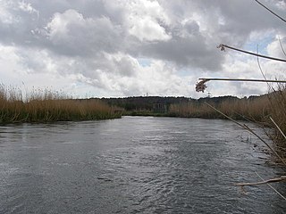
Rew Down is a 23.5-hectare biological Site of Special Scientific Interest and Local Nature Reserve located on the south-east edge of the Isle of Wight in the hills to the west of Ventnor.
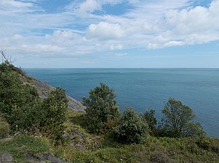
Bonchurch Landslips is a 28.2 hectare site of special scientific interest which is located north-east of Ventnor, Isle of Wight. A wooded coastal landslip zone, the site was notified in 1977 for both its biological and geological features.
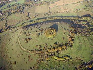
St. Catherine's Hill is a 43-hectare (110-acre) biological Site of Special Scientific Interest on the outskirts of Winchester in Hampshire. It is managed by Hampshire and Isle of Wight Wildlife Trust, and most of it is an Iron Age hillfort, which is a Scheduled Monument.
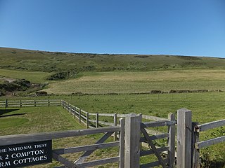
Compton Down is a hill on the Isle of Wight just to the east of Freshwater Bay. It is part of the chalk ridge which forms the "backbone" of the Isle of Wight. It runs east to west, is approximately three miles (4.8 km) long and is predominantly grass downland. The Down is owned and managed by the National Trust and it provides the setting for the Freshwater Bay Golf Course at its western end.
Garston's Down is an area of downland on the Isle of Wight, rising to an altitude of 151 m (495 ft). It is located in the centre of the island, south of Carisbrooke and west of Gatcombe, and is one of the best remaining inland examples of unimproved chalk downland. An area of 20.3 hectares was notified as a Site of Special Scientific Interest (SSSI) in 1971 for its biological features. The down is situated in a remote area and provides extensive views over the surrounding countryside and distant coast.
Rowridge Valley is a 39.8-hectare (98-acre) Site of Special Scientific Interest (SSSI) that is 2 km (1.2 mi) east of the village of Calbourne and just east of the Rowridge Transmitter mast in the Isle of Wight. The site was notified in 1987 under the Wildlife and Countryside Act 1981 for its biological features. The site is an example of semi-natural woodland on chalk soil and is of special botanical importance as the only site in Britain where the wood calamint is to be found.

Castle Hill is a 114.6-hectare (283-acre) biological Site of Special Scientific Interest on the eastern outskirts of Brighton in East Sussex. It is a Special Area of Conservation and Nature Conservation Review site. The northern half is a national nature reserve

Hackpen, Warren & Gramp's Hill Downs is a 71.4-hectare (176-acre) biological Site of Special Scientific Interest in Letcombe Bassett in Oxfordshire.

Beeding Hill to Newtimber Hill is a 321-hectare (790-acre) biological and geological Downland Site of Special Scientific Interest (SSSI) north of Shoreham-by-Sea in West Sussex. It is a Nature Conservation Review site, Grade 2, and it includes Devil's Dyke Geological Conservation Review site.
Avon Valley is a 1,403.8-hectare (3,469-acre) biological Site of Special Scientific Interest which stretches from Christchurch in Dorset to Bickton, south of Fordingbridge Hampshire. It is a Nature Conservation Review site, a Ramsar site, a Special Area of Conservation and a Special Protection Area. An area of 159 hectares is Blashford Lakes, a nature reserve managed by the Hampshire and Isle of Wight Wildlife Trust,

Broughton Down is a 45.8-hectare (113-acre) biological Site of Special Scientific Interest west of Broughton in Hampshire. The eastern half is a nature reserve managed by the Hampshire and Isle of Wight Wildlife Trust
