Colwell Bay

Last updated

Colwell Bay
Site of Special Scientific Interest
Colwell Bay.jpg
Location Isle of Wight
Grid reference SZ323873
InterestGeological
Area13.56 hectare
Notification 1959
Location map Natural England
Isle of Wight UK location map.svg
Red pog.svg
Colwell Bay
Colwell Bay on the Isle of Wight

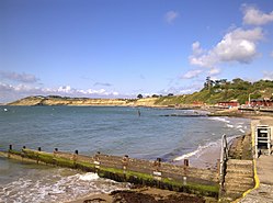
Colwell Bay (grid reference SZ323873 ) is a bay in the west of the Isle of Wight. It is located between the towns of Totland and Yarmouth. The bay's northernmost point is Cliff's End (Fort Albert) the closest point of the Island to the British mainland, with Hurst Castle lying at the end of a long peninsula just 1500 metres (a little less than a mile) to the northwest. The southernmost point is Warden Point.

Colwell Bay has a popular beach, with two miles of sand and shingle, and facilities including cafes, shops and equipment hire outlets.

An area of 13.56 hectares has been notified as a geological Site of Special Scientific Interest, notification originally taking place in 1959. The site is significant for its Eocene geology and maritime vegetated soft cliff habitat. [1]

It is the location of three chines: Colwell Chine, Brambles Chine and Linstone Chine.

Colwell Bay is on the A3054 road and near the western end of the A3055 road. Public transport to the area is provided by Southern Vectis route 7 and the Needles Tour.

Related Research Articles

<span class="mw-page-title-main">Chaleur Bay</span> Arm of the Gulf of Saint Lawrence between Quebec and New Brunswick, Canada

Chaleur Bay, also Chaleurs Bay, Bay of Chaleur, is an arm of the Gulf of Saint Lawrence located between Quebec and New Brunswick, Canada.

<span class="mw-page-title-main">Chine</span> Steep-sided river valley

A chine is a steep-sided coastal gorge where a river flows to the sea through, typically, soft eroding cliffs of sandstone or clays. The word is still in use in central Southern England—notably in East Devon, Dorset, Hampshire and the Isle of Wight—to describe such topographical features. The term 'bunny' is sometimes used to describe a chine in Hampshire. The term chine is also used in some Vancouver suburbs in Canada to describe similar features.

<span class="mw-page-title-main">Alum Bay</span>

Alum Bay is a bay near the westernmost point of the Isle of Wight, England, within close sight of the Needles rock formation. Of geological interest and a tourist attraction, the bay is noted for its multi-coloured sand cliffs. The waters and adjoining seabed form part of the Needles Marine Conservation Zone and the shore and heath above are part of the Headon Warren and West High Down Site of Special Scientific Interest.

<span class="mw-page-title-main">The Needles</span> Sea stacks off the Isle of Wight, England

The Needles are a row of three stacks of chalk that rise about 30 metres (98 ft) out of the sea off the western extremity of the Isle of Wight in the English Channel, United Kingdom, close to Alum Bay and Scratchell's Bay, and part of Totland, the westernmost civil parish of the Isle of Wight. The Needles Lighthouse stands at the outer, western end of the formation. Built in 1859, it has been automated since 1994. The waters and adjoining seabed form part of the Needles Marine Conservation Zone and the Needles along with the shore and heath above are part of the Headon Warren and West High Down Site of Special Scientific Interest.

<span class="mw-page-title-main">Blackgang Chine</span> Amusement park on the Isle of Wight

Blackgang Chine is the oldest amusement park in the United Kingdom, having opened in 1843. Named after a now-destroyed chine in the soft Cretaceous cliffs, it is about 6 miles from Ventnor at the southern tip of the Isle of Wight just below St Catherine's Down. Blackgang Chine and its sister park Robin Hill are owned by the Dabell family. Blackgang Chine is home to many lands of imagination, including Pirate Cove, Restricted Area 5, Fairy Land and Village, and Cowboy Town. Owing to the unstable land on which the park is situated, landslides occur frequently, meaning that attractions have been moved further inland to safer ground on several occasions.

<span class="mw-page-title-main">York River (Virginia)</span> River in Virginia, United States

The York River is a navigable estuary, approximately 34 miles (55 km) long, in eastern Virginia in the United States. It ranges in width from 1 mile (1.6 km) at its head to 2.5 miles (4.0 km) near its mouth on the west side of Chesapeake Bay. Its watershed drains an area of the coastal plain of Virginia north and east of Richmond.

<span class="mw-page-title-main">Mount's Bay</span> Bay on the south coast of Cornwall, England

Mount's Bay is a bay on the English Channel coast of Cornwall, England, stretching from the Lizard Point to Gwennap Head. In the north of the bay, near Marazion, is St Michael's Mount; the origin of name of the bay. In summer, it is a generally benign natural harbour. However, in winter, onshore gales present maritime risks, particularly for sailing ships. There are more than 150 known wrecks from the nineteenth century in the area. The eastern side of the bay centred around Marazion and St Michael's Mount was designated as a Marine Conservation Zone in January 2016.

The Undercliff is the name of several areas of landslip on the south coast of England. They include ones on the Isle of Wight; on the Dorset-Devon border near Lyme Regis; on cliffs near Branscombe in East Devon; and at White Nothe, Dorset. All arose from slump of harder strata over softer clay, giving rise to irregular landscapes of peaks, gullies and slipped blocks, that have become densely vegetated due to their isolation and change of land use. The Kent coast at Folkestone and Sandgate also has similar undercliff areas.

<span class="mw-page-title-main">Baker's Haulover Inlet</span> Ocean inlet in Florida, US

Baker's Haulover Inlet is a man-made channel in Miami-Dade County, Florida connecting the northern end of Biscayne Bay with the Atlantic Ocean. The inlet was cut in 1925 through a narrow point in the sand between the cities of Bal Harbour and Sunny Isles. It is the location of an official nude beach, recreation areas and marina in the 99-acre Haulover Park. A fixed bridge carries State Road A1A across the inlet.

<span class="mw-page-title-main">Barton on Sea</span> Human settlement in England

Barton on Sea is a cliff-top village in Hampshire, England close to the town New Milton, which is its civil parish to the north. As a settlement, Barton has a history dating back to Anglo-Saxon times. Barton is notable for the many fossils to be found in the Barton geological beds in the cliffs, as well as for the significant sea defences built to guard the cliffs against coastal erosion. Barton on Sea is a very popular retirement location. Approximately 36% of the population are retired. The population of Barton in the 2001 census was 6,849.

<span class="mw-page-title-main">Slickstones Quarry, Cromhall</span> Quarry in Gloucestershire

Slickstones Quarry, Cromhall is a 2.7 hectare geological Site of Special Scientific Interest near the village of Cromhall, South Gloucestershire, England notified in 1966.

Bembridge School And Cliffs SSSI is a 12.58 hectare geological Site of Special Scientific Interest near Bembridge on the Isle of Wight, notified in 1999.

The Little Magothy River runs 2.5 miles (4.0 km) through Anne Arundel County in the U.S. state of Maryland. It is located southeast of the Magothy River, just outside its mouth and north of the Severn River.

<span class="mw-page-title-main">Isle of Wight Coastal Path</span> Long-distance footpath on the Isle of Wight, England

The Isle of Wight Coastal Path is a circular long-distance footpath of 70 miles (113 km) around the Isle of Wight, UK. It follows public footpaths and minor lanes, with some sections along roads.

<span class="mw-page-title-main">Headon Warren and West High Down SSSI</span>

<span class="mw-page-title-main">Shanklin Chine</span> Tourist attraction in Shanklin, Isle of Wight

<span class="mw-page-title-main">Redcliff Point</span>

Redcliff Point is on the south coast of England, to the east of Weymouth in Dorset. It lies just past the eastern end of the sweeping Weymouth Bay on the Jurassic Coast, a UNESCO World Heritage landscape known for its geology. Fossils can be found in the Upper Oxford Clay in this area.

<span class="mw-page-title-main">Furzy Cliff</span> Geological formation in Dorset, England

Furzy Cliff, also known as Jordan's Cliff, is located on the coast near the village of Preston, just to the east of Weymouth in Dorset, England. It is at the north-eastern end of Weymouth Beach, looking out over Weymouth Bay to Portland Harbour and the Isle of Portland. Close by to the east is Bowleaze Cove. Just inland to the north are Jordan Hill and the remains of the Jordan Hill Roman Temple. On the top of the cliff there is a large grass area with good views.

<span class="mw-page-title-main">Flower's Barrow</span>

Flower’s Barrow is an Iron Age hillfort, built over 2500 years ago, above Worbarrow Bay in Dorset on the south coast of England.

The Undercliff, Isle of Wight, England is a tract of semi-rural land, around 5 miles (8.0 km) long by 0.25–0.5 miles (0.40–0.80 km) wide, skirting the southern coast of the island from Niton to Bonchurch. Named after its position below the escarpment that backs this coastal section, its undulating terrain comprises a mix of rough pasture, secondary woodland, parkland, grounds of large isolated houses, and suburban development. Its sheltered south-facing location gives rise to a microclimate considerably warmer than elsewhere on the island. Although inhabited, the Undercliff is an area prone to landslips and subsidence, with accompanying loss of property over time. Settlements along the Undercliff, from west to east, are: lower Niton, Puckaster, St Lawrence, Steephill, the town of Ventnor, and Bonchurch.

References

50°41′04″N1°32′39″W / 50.68446°N 1.54416°W / 50.68446; -1.54416