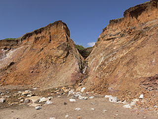
Churchill Chine is a geological feature on the south west coast of the Isle of Wight, England. It is west of the village of Brook and just east of Hanover Point. It is a small sandy coastal gully, one of a number of such chines on the island created by stream erosion of soft Cretaceous rocks. It leads from the 30 foot high clifftop to the beach of Brook Bay.
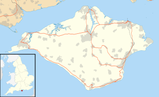
The Isle of Wight is a county and the largest and second-most populous island in England. It is in the English Channel, between 2 and 5 miles off the coast of Hampshire, separated by the Solent. The island has resorts that have been holiday destinations since Victorian times, and is known for its mild climate, coastal scenery, and verdant landscape of fields, downland and chines.
England is a country that is part of the United Kingdom. It shares land borders with Wales to the west and Scotland to the north-northwest. The Irish Sea lies west of England and the Celtic Sea lies to the southwest. England is separated from continental Europe by the North Sea to the east and the English Channel to the south. The country covers five-eighths of the island of Great Britain, which lies in the North Atlantic, and includes over 100 smaller islands, such as the Isles of Scilly and the Isle of Wight.
Brook is a village on the Isle of Wight, England. According to the Post Office the 2011 census population was included in the civil parish of Brighstone.
The Chine carries water from a lake about 100m to the north, just across the nearby Military Road and also from a small brook that runs down the hillside from Dunsbury. The gully contains a small waterfall which drops down to the beach.
The Isle of Wight Coastal Path is a circular long-distance footpath of 70 miles (113 km) around the Isle of Wight, UK. It follows public footpaths and minor lanes, with some sections along roads.
This page is based on this Wikipedia article Text is available under the CC BY-SA 4.0 license; additional terms may apply. Images, videos and audio are available under their respective licenses.
Related Research Articles
A chine is a steep-sided coastal gorge where a river flows to the sea through, typically, soft eroding cliffs of sandstone or clays. The word is still in use in central Southern England—notably in East Devon, Dorset, Hampshire and the Isle of Wight—to describe such topographical features. The term 'bunny' is sometimes used to describe a chine in Hampshire. The term chine is also used in some Vancouver suburbs in Canada to describe similar features.
Blackgang is a village on the south-western coast of the Isle of Wight. It is best known as the location of the Blackgang Chine amusement park which sits to the south of St Catherine's Down.
Luccombe Chine is a geological feature and visitor attraction south of the village of Luccombe on the Isle of Wight, England. A wooded coastal ravine, one of a number of such chines on the island created by stream erosion of soft Cretaceous rocks, it leads from the clifftop to Luccombe Bay.
Whale Chine is a geological feature near Chale on the south-west coast of the Isle of Wight, England. One of a number of such chines on the island created by stream erosion of soft Cretaceous and Jurassic rocks, it is a narrow and steep coastal ravine dropping 140 feet through Lower Greensand rocks from clifftop farmland to Chale Bay.
Walpen Chine is a geological feature on the south west coast of the Isle of Wight, England. It is west of the village of Chale. It is a sandy coastal ravine, one of a number of such chines on the island created by stream erosion of soft Cretaceous rocks. It leads from the 190 feet high clifftop next to the Isle of Wight coastal path to a knickpoint approximately halfway down the cliff face above Chale Bay beach.
Ladder Chine is a geological feature on the south west coast of the Isle of Wight, England. It is west of the village of Chale. It is a sandy coastal ravine, one of a number of such chines on the island created by stream erosion of soft Cretaceous rocks. It leads from the 190 foot high clifftop to a knickpoint approximately halfway down the cliff face above Chale Bay beach.
New Chine is a geological feature on the south west coast of the Isle of Wight, England. It is west of the village of Chale. It is a sandy coastal ravine, one of a number of such chines on the island created by stream erosion of soft Cretaceous rocks. It leads from the 190 foot high clifftop to a knickpoint approximately one third of way down the cliff face above Chale Bay beach.
Barnes Chine is a geological feature on the south west coast of the Isle of Wight, England. The chine lies just to the west of a small rise called Barnes High and south west of the hamlet of Yafford. It is a small sandy coastal ravine, one of a number of such chines on the island created by erosion of the cliff edge made of soft Cretaceous rock.
Compton Chine is a geological feature on the south west coast of the Isle of Wight, England. It lies between the village of Brook to the east and Freshwater Bay to the west. It is a small sandy coastal gully, one of a number of such chines on the island created by stream erosion of soft Cretaceous rocks. It leads from the 50 foot high clifftop to the beach of Compton Bay.
Brook Chine is a geological feature on the south west coast of the Isle of Wight, England. It lies just to the west of the village of Brook. The hamlet of Brookgreen runs along its southern edge.
Chilton Chine is a geological feature on the south west coast of the Isle of Wight, England. It lies to the west of the village of Brighstone. It is a small coastal gully, one of a number of such chines on the island created by stream erosion of soft Cretaceous rocks.
Grange Chine and Marsh Chine form a geological feature on the south west coast of the Isle of Wight, England. They lie to the south of the village of Brighstone.
Shepherd's Chine is a geological feature on the south west coast of the Isle of Wight, England. It lies to the west of the village of Little Atherfield.
Cowleaze Chine is a geological feature on the south west coast of the Isle of Wight, England. It lies to the west of the village of Little Atherfield.
Shippards Chine is a geological feature on the south west coast of the Isle of Wight, England. It is west of the village of Brook and just north of Hanover Point.
Widdick Chine is a geological feature on the west coast of the Isle of Wight, England. It is west of the village of Totland.
Brighstone Bay is a bay on the south west coast of the Isle of Wight, England. It lies to the south and west of the village of Brighstone from which it takes its name. It faces south west towards the English Channel, its shoreline is 7 km in length and is gently curving. It stretches from Sudmoor Point in the north west to Artherfield Point in the south east.
Brook Bay is a bay on the south western coast of the Isle of Wight, England. It lies to the west of the village of Brook. It faces south west out into the English Channel. It stretches about 2km from Hanover Point in the east to Sudmoor Point to the west. Much of the surrounding land, including the hamlet of Brookgreen is owned by the National Trust.
Buddle Brook a small river on the Isle of Wight, England. The Brook drains water from the southern side of Brighstone Down and as far to the east as the village of Shorwell. Its flow is the greatest of the streams in the South-West of the Island. Near the village of Brighstone its body is split into a series of mill ponds built to power Yafford Mill and Brighstone Mill, and controlled ways passing through the village and under the noted local landmark, the Dragon Tree Brighstone. Beyond the village the stream is re-connected into one and flows into Grange/Marsh Chine. These are heavily vegetated and are the largest chine on the Island. The Brook runs all the way to the beach where its mouth is at least 4m wide. Once the stream reaches the pebble beach it soaks in and disappears.