
The Tay Bridge carries the railway across the Firth of Tay in Scotland between Dundee and the suburb of Wormit in Fife. Its span is 2.75 miles. It is the second bridge to occupy the site.

The River Itchen in Hampshire, England, rises to the south of New Alresford and flows 26 miles (42 km) to meet Southampton Water below the Itchen Bridge. The Itchen Navigation was constructed in the late 17th and early 18th centuries to enable barges to reach Winchester from Southampton Docks, but ceased to operate in the mid-19th century and is largely abandoned today.

Southampton, Itchen is a constituency represented in the House of Commons of the UK Parliament since 2015 by Royston Smith, a Conservative member of parliament. Discounting the Speaker returned in the early 1970s in two elections, local voters have elected the MP from only two parties alternately for various periods, with one party reaffiliation (defection) between elections when the Labour Party split in the 1980s.
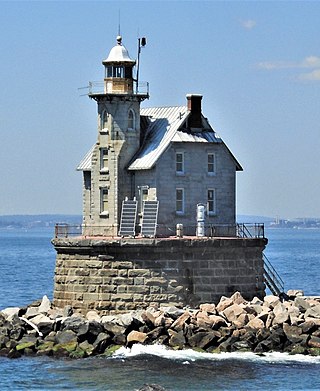
Race Rock Light is a lighthouse on Race Rock Reef, a dangerous set of rocks on Long Island Sound southwest of Fishers Island, New York and the site of many shipwrecks. It is currently owned and maintained by the New London Maritime Society as part of the National Historic Lighthouse Preservation Act program.

Bitterne is an eastern suburb and ward of Southampton, England.

Bitterne Manor is a suburb of Southampton surrounding the manor house of the same name. It is located on the eastern bank of the River Itchen, across Cobden Bridge from St Denys.

Bitterne Park is a suburb and Electoral Ward of Southampton, England, on the Eastern bank of the River Itchen, built on sloping parkland which once formed part of Bitterne Manor.
St Denys is a partially riverside district of Southampton, England, centred 1.5 miles (2.4 km) north north-east of the city centre facing variously Bitterne Park and quay across the River Itchen estuary. The river is here spanned in the mid-east extreme of the district by Cobden Bridge, one of five within the city's broad boundaries, six including the railway bridge 100 m south. It is separated from the city centre by the districts sometimes known as Bevois Valley and New Town, in turn and to the south a riverside boardwalk allows pedestrian and bicycle access to the Mount Pleasant Industrial Estate and Northam.

Sholing, previously Scholing, is a district on the eastern side of the city of Southampton in Southern England. It is located between the districts of Bitterne, Thornhill and Woolston.
Southampton is a city in Hampshire, England. The area has been settled since the Stone Age. Its history has been affected by its geographical location, on a major estuary on the English Channel coast with an unusual double high-tide, and by its proximity to Winchester and London; the ancient and modern capitals of England. Having been an important regional centre for centuries, Southampton was awarded city status by Queen Elizabeth II in 1964 .
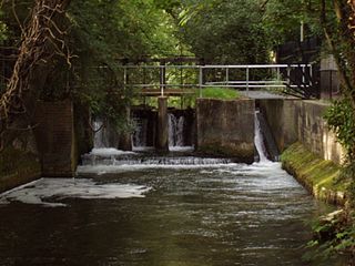
The Itchen Navigation is a 10.4-mile (16.7 km) disused canal system in Hampshire, England, that provided an important trading route from Winchester to the sea at Southampton for about 150 years. Improvements to the River Itchen were authorised by Act of Parliament in 1665, but progress was slow, and the navigation was not declared complete until 1710. It was known as a navigation because it was essentially an improved river, with the main river channel being used for some sections, and cuts with locks used to bypass the difficult sections. Its waters are fed from the River Itchen. It provided an important method of moving goods, particularly agricultural produce and coal, between the two cities and the intervening villages.

The Port of Southampton is a passenger and cargo port in the central part of the south coast of England. The modern era in the history of the Port of Southampton began when the first dock was inaugurated in 1843. After the Port of Felixstowe, Southampton is the second largest container terminal in UK, with a handled traffic of 1.5 million twenty-foot equivalent units (TEU). It also handles cruise ships, roll-on roll-off, dry bulk, and liquid bulk.

The Northam Bridge is a road bridge across the River Itchen in Southampton, England, linking the suburbs of Northam and Bitterne Manor. The current bridge was the first major prestressed concrete road bridge to be built in the United Kingdom. The bridge carries the A3024 road as a dual carriageway, with two lanes on each carriageway.

Cobden is a suburb to the north of Greymouth on the West Coast of New Zealand. The Grey River separates Cobden from the rest of Greymouth. To the north is the Rapahoe Range, also called the Twelve Apostles Range. State Highway 6 skirts the south-eastern edge of Cobden.
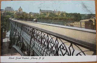
The Hawk Street Viaduct was a bridge spanning the Sheridan Hollow neighborhood in Albany, New York. It carried Hawk Street from Clinton Avenue to Elk Street. Completed in 1890, it was demolished in 1970 after decades of neglect which had caused it to be limited to pedestrian traffic only in 1968. It was the first cantilever arch bridge in the world.

The Caledonian Railway Bridge is a bridge crossing the River Clyde at Broomielaw in Scotland. It is adjacent to Glasgow Central Station.
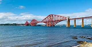
The Forth Bridge is a cantilever railway bridge across the Firth of Forth in the east of Scotland, 9 miles west of central Edinburgh. Completed in 1890, it is considered a symbol of Scotland, and is a UNESCO World Heritage Site. It was designed by English engineers Sir John Fowler and Sir Benjamin Baker. It is sometimes referred to as the Forth Rail Bridge, although this is not its official name.

Angellala Rail Bridge is a heritage-listed railway bridge on the Roma-Cunnamulla railway line over Angellala Creek in Sommariva in the Shire of Murweh, Queensland, Australia. It was designed by Henry Charles Stanley and built from c. 1885 to 1994. It was added to the Queensland Heritage Register on 21 October 1992.
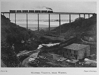
Staithes Viaduct was a railway bridge that straddled Staithes Beck at Staithes, Yorkshire, England. It was north of the closed Staithes railway station. It was known for an anemometer, a fitting to tell the signaller if winds across the viaduct were too strong for crossing trains.

The Murray River road bridge, Murray Bridge is a bridge in the town of Murray Bridge, located 76 km (47 mi) south-east of Adelaide on the Murray River north of Lake Alexandra. The bridge was built as a road bridge in 1879 and converted for mixed road/rail use shortly thereafter. The tiny settlement of Edwards Crossing was renamed Murray Bridge when a new railway bridge was constructed in 1924. Since then, the bridge has been used for road traffic only.


