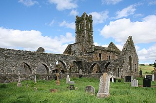
Timoleague Friary, also known as Timoleague Abbey, is a ruined medieval Franciscan friary in Timoleague, County Cork, Ireland, on the banks of the Argideen River overlooking Courtmacsherry Bay. It was built on the site of an early Christian monastic site founded by Saint Molaga, from whom the town of Timoleague derives its name. The present remains date from roughly the turn of the fourteenth century and were burnt down by British forces in the mid-seventeenth century, at which point it was an important ecclesiastical centre that engaged in significant trade with Spain.

The Buttevant Franciscan Friary is a ruined 13th-century Franciscan friary is situated in the middle of the town of Buttevant, County Cork, Ireland. The Augustinian friary in nearby Ballybeg is often confused with the Buttevant Franciscan Friary in historical documents.
Southwick Priory or Our Lady at Southwick was a priory of Augustinian canons founded in Portchester Castle on Portsmouth Harbour and later transferred 2 miles (3.2 km) north to Southwick, Hampshire, England. It ceased at the Dissolution of the Monasteries in 1538.

Greyfriars Church is an evangelical Anglican church, and former Franciscan friary, in the town centre of Reading in the English county of Berkshire. The church forms part of the Church of England's Diocese of Oxford.

Southampton is a port city and unitary authority in Hampshire, England. It is located approximately 80 miles (130 km) southwest of London, 20 miles (32 km) west of Portsmouth, and 20 miles (32 km) southeast of Salisbury. Southampton had a population of 253,651 at the 2011 census, making it one of the most populous cities in southern England.
St Dominic's Holy Well is a natural spring located in the parish of St George, Truro, Cornwall.
Conduit Head is a 1910 house located off the Madingley Road (A1303) on the western outskirts of Cambridge, England. Built in 1910, it was designed by Harry Redfern for Francis Darwin, and was built for Darwin's daughter Frances on the occasion of her marriage to F. M. Cornford. The architectural historians Simon Bradley and Nikolaus Pevsner describe the house as "gabled, rural and relaxed".

Blackfriars, Bristol was a Dominican priory in Broadmead, Bristol, England. It was founded by Maurice de Gaunt in 1227 or 1228. Llywelyn ap Dafydd, son of Dafydd ap Gruffydd, the last native Prince of Wales, was buried in the cemetery of the priory. Following the Dissolution of the Monasteries in the 16th century, surviving parts of the priory became a guildhall for the Smiths and Cutlers Company, the Bakers Company, a workhouse and then Bristol Quaker meeting house. In the 20th century, it has housed the local register office, a theatre company, and a restaurant.

Greyfriars, in Bristol, England, was a Franciscan friary. The name Greyfriars derived from the grey robes worn by the friars. It was founded at some time before 1234, within the town walls and then moved to Lewin's Mead in 1250. The site included extensive gardens surrounded by a stone wall. Following the Dissolution of the Monasteries in the sixteenth century, the premises were leased to the town council in 1541, who desired to use the stone to make repairs to the town walls, and the harbour facilities. In succeeding centuries many different uses have been made of the site, which is currently occupied by an office block and part of Bristol Dental School.

Derby Dominican Priory, also known as Derby Black Friary, or Blackfriars, Derby, was a Dominican priory situated in the town of Derby, England. It was also named in different sources as a friary, monastery and convent, but was officially a priory as it was headed by a prior and the Dominican Order calls all their houses Priories. The "Black" came from the colour of the mantles worn by the friars of the order.
Dorchester Friary, also known as Dorchester Priory, was a Franciscan friary formerly located in Dorchester, Dorset, England.
Greyfriars Nottingham was a Franciscan friary in Nottinghamshire, England. It was founded c. 1224–1230, and dissolved in 1539 as part of King Henry VIII's Dissolution of the Monasteries. The site of the friary is now occupied by the Broadmarsh Shopping Centre.
Guildford Friary was a medieval monastic house in Guildford, Surrey, England. It was founded c. 1275 by Eleanor of Provence, wife of Henry III and occupied a site of around 10 acres (4.0 ha) on the east side of the River Wey. It was dissolved in 1537.
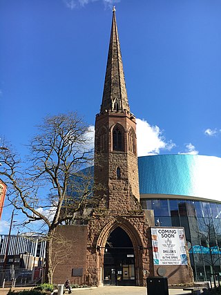
Greyfriars was a medieval Franciscan priory in Coventry, England. The original monastic buildings were lost in the Reformation; the spire standing on the site today was most recently part of a 19th-century church that was destroyed in an air raid in the Second World War. The spire, also called Christchurch Steeple, is a Grade II* listed building.
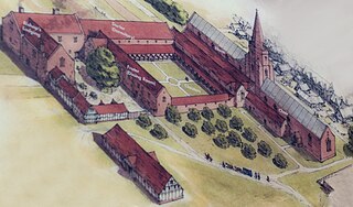
The Franciscan Friary was once a large estate located on the west side of Lichfield city centre in Staffordshire. The estate was built and inhabited by the Franciscan Friars from 1237. At one time the estate consisted of a large church, a cloister, dormitory lodge and a refectory building as well as many other domestic dwellings.
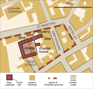
Greyfriars, Leicester, was a friary of the Order of Friars Minor, commonly known as the Franciscans, established on the west side of Leicester by 1250, and dissolved in 1535. Following dissolution the friary was demolished and the site levelled, subdivided, and developed over the following centuries. The locality has retained the name Greyfriars particularly in the streets named "Grey Friars", and the older "Friar Lane".
Newark Friary, also known as Newark Greyfriars and Newark Observant Friary, was a friary of the reformed "Observant Friars" of the Franciscan Order, located in the town of Newark, Nottinghamshire, England. The friary as founded by Henry VII around 1499, and dissolved by his son Henry VIII in 1539.
Llanfaes Friary was a Franciscan friary in the now vanished medieval town of Llanfaes, close to what is now Beaumaris, in south east Anglesey, Wales. It was founded around 1237 in memory of Joan, wife of Llywelyn ab Iorwerth. The Friary survived the depopulation of the town, but was dissolved in 1538 and most of the buildings dismantled soon afterwards. The land became an estate on which, in 1623, Rowland Whyte built a house which he called Friars. It became one of the many properties of the Bulkeley family, and was substantially rebuilt in 1866. By the 20th century the house and grounds were owned by James Hartley Burton. In 1939 they were requisitioned for wartime use, adapting and repairing flying boats, by Saunders-Roe, who continued after the war with a wide variety of light engineering activities. The industrial uses finally came to an end in the late 1990s. An archaeological dig on the site in 1991 identified substantial buried remains of the friary church and other monastic buildings. The site is a Scheduled monument.
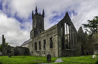
Ennis Friary was a Franciscan friary in the town of Ennis, County Clare, Ireland. It was established in the middle of the 13th century by the ruling O'Brien dynasty who supported it for most of its existence. Following the suppression of the monasteries in the 16th century, the friary continued to function for a while despite the loss of its lands. In the early 17th century, the buildings were handed over to the Church of Ireland as a place of worship. It was used as such until the late 19th century. After the construction of a new Church of Ireland building, the friary fell into ruin. Managed by the Office of Public Works since the late 19th century, it was formally returned to the Franciscan Order in 1969.

Westwood Woodland Park is a 49.5-hectare (122-acre) Local Nature Reserve in Southampton in Hampshire. It is owned by Hampshire County Council and managed by Hampshire County Council and Southampton City Council. The site is split in two by a stream, the 'Tickleford Gully'. The park forms the boundary of Southampton and Netley.


