Tron is a 1982 science fiction film produced by Walt Disney Productions.

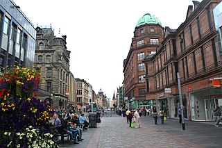
Buchanan Street is one of the main shopping thoroughfares in Glasgow, the largest city in Scotland. It forms the central stretch of Glasgow's famous shopping district with a generally more upmarket range of shops than the neighbouring streets: Argyle Street, and Sauchiehall Street.

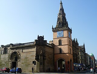
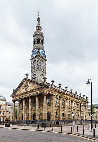
The St George's Tron Church, in Glasgow, Scotland, is a Church of Scotland church in the city centre, located in Nelson Mandela Place, previously known as St George's Place, fronting Buchanan Street at West George Street, along from Queen Street Station. It should not be confused with the 17th-century Tron Church, which lies to the south-west on Trongate and was redeveloped in the 1980s as the Tron Theatre. Located right on the busiest shopping street in Scotland, the building is a significant presence, and the oldest in the area. It stands as a terminating vista for West George Street.

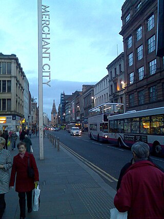
The Merchant City, a new name introduced through urban renewal by the Scottish Development Agency and the city council in the 1980s is one part of the metropolitan central area of Glasgow. It commences at George Square and goes eastwards reaching Glasgow Cross, in the centre of Glasgow, Scotland. The eastern fringe of the Merchant City contains part of Glasgow's original medieval street plan, which stretches northwards towards neighbouring Townhead.

The Tron Kirk is a former principal parish church in Edinburgh, Scotland. It is a well-known landmark on the Royal Mile. It was built in the 17th century and closed as a church in 1952. Having stood empty for over fifty years, it was used as a tourist information centre for several years in the mid 2000s and, more recently, was the site of the Edinburgh World Heritage Exhibition and John Kay’s book and gift shop.
The Tron Theatre is located in Glasgow, Scotland. The theatre was formerly known as the Tron Kirk. It began as the Collegiate Church of Our Lady and St. Anne.

Glasgow Cross is at the hub of the ancient royal burgh and now city of Glasgow, Scotland, close to its first crossing over the River Clyde. It marks the notional boundary between the city centre and the East End

The Collegiate Church of the Blessed Virgin Mary and St Anne, Glasgow, was founded in the middle of the sixteenth century by James Houstoun, Subdean of Glasgow and Rector of the University of Glasgow from 1534 to 1541. The church was located on the south side of Trongate. Two copies of its Latin constitution, dating from 1549, have survived in the city archives. These provide detailed information about the structure of the college and its funding. James Houstoun's original provision was for a Provost, eight canons or prebends, and three choristers, but later benefactions extended this. The prebends were supported by property scattered across the city, and in Dalry, Maybole and Rutherglen.
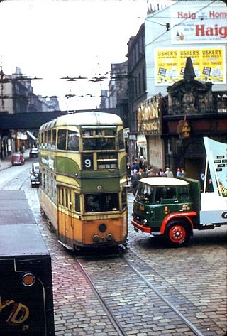
Glasgow Corporation Tramways were formerly one of the largest urban tramway systems in Europe. Over 1000 municipally-owned trams served the city of Glasgow, Scotland, with over 100 route miles by 1922. The system closed in 1962 and was the last city tramway in Great Britain.
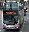
Argyle Street is a major thoroughfare in the city centre of Glasgow, Scotland.

The A749 road in Scotland connects East Kilbride with Glasgow city centre via Rutherglen and Bridgeton.
Glasgow City Centre is the central business district of Glasgow, Scotland. It is bordered by the Saltmarket, High Street and Castle Street to the east, the River Clyde to the south, and the M8 motorway to the west and north. It is made up of the areas of Garnethill, Blythswood Hill, and Merchant City, though parts of Cowcaddens, Townhead, Anderston and Calton also fall within its boundaries.
The Glasgow Tramway and Omnibus Company operated a horse-drawn tramway service in Glasgow between 1872 and 1894. The tram system was then taken into municipal ownership, becoming Glasgow Corporation Tramways.
St Andrew's Cross, also known as Eglinton Toll, is a road junction in the south side of the city of Glasgow, Scotland. First constructed during the early 1800s, the junction formerly held several buildings including a power station and cinema, but have been removed for a variety of reasons. Since 1946 when the junction underwent a realignment, the two roads no longer intersect.
St Andrew's Square is a public square in the city of Glasgow, Scotland and lies to the south east corner of Glasgow Cross, close to Glasgow Green. The square is noted for its immense 18th-century classical church, St Andrew's in the Square, from which the square takes its name. The church was completed in 1758, to the designs of architect Allan Dreghorn and master mason Mungo Naismith and is among the finest of its type anywhere in Britain. The interior has lavish 18th century rococo plasterwork. The building is Category A listed. It is one of six squares in the city centre.

The Tron Church is an evangelical Presbyterian church which meets in three locations across Glasgow—in the city centre on Bath Street, in the Kelvingrove area of the West end of Glasgow, and on the Southside of Glasgow near Queen's Park.

Gallowgate railway station was a station on the City Union Line in Glasgow, Scotland. It was situated a short distance east of Glasgow Cross at the junction of Gallowgate and East Nile Street, today Molendinar Street.

Gallowgate is a neighbourhood of the city of Glasgow, Scotland. It takes its name from the major thoroughfare through the territory, which is part of the A89 road. Administratively, it is part of the Calton ward of the Glasgow City Council area.

Sandyford is an area of Glasgow, Scotland. It is north of the River Clyde and forms part of the western periphery of the city centre. Formerly the name of a ward under Glasgow Town Council in the first part of the 20th century, it is within a continuous area of fairly dense urban development bordering several other neighbourhoods whose mutual boundaries have blurred over time, and is possibly less well known than all of the places which adjoin it, particularly Anderston and Finnieston.
Glassford Street is a major thoroughfare in the city of Glasgow, the largest city in Scotland. The street runs north from the junction of Argyle Street and Trongate through the Merchant City until it meets Ingram Street.