The A8 is a major road in Scotland, connecting Edinburgh to Greenock via Glasgow. Its importance diminished following the construction of the M8 motorway which also covers the route between Edinburgh and Glasgow.

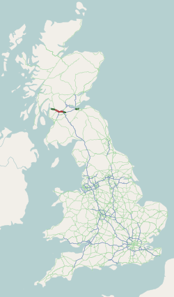
The M8 is the busiest motorway in Scotland. It connects the country's two largest cities, Glasgow and Edinburgh, and serves other large communities including Airdrie, Coatbridge, Greenock, Livingston and Paisley. The motorway is 60 miles (97 km) long. A major construction project to build the final section between Newhouse and Baillieston was completed on 30 April 2017. The motorway has one service station, Heart of Scotland Services, previously named Harthill due to its proximity to the village.
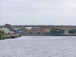
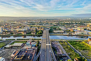
The Kingston Bridge is a balanced cantilever dual-span ten lane road bridge made of triple-cell segmented prestressed concrete box girders crossing the River Clyde in Glasgow, Scotland.
Anderston is an area of Glasgow, Scotland. It is on the north bank of the River Clyde and forms the south western edge of the city centre. Established as a village of handloom weavers in the early 18th century, Anderston was an independent burgh of barony from 1824 until it was incorporated into the City of Glasgow in 1846.
The city of Glasgow, Scotland, has a transport system encompassing air, rail, road and an underground light metro line. Prior to 1962, the city was also served by trams. Commuters travelling into Glasgow from the neighbouring local authorities of North and South Lanarkshire, Renfrewshire, East Renfrewshire, and East and West Dunbartonshire have a major influence on travel patterns, with tens of thousands of residents commuting into the city each day. The most popular mode of transport in the city is the car, used by two-thirds of people for journeys around the city.

Charing Cross (Glasgow) is a railway station close to the centre of Glasgow, Scotland, serving the district of the same name. It is managed by ScotRail and is served by trains on the North Clyde Line.
The Glasgow Inner Ring Road is a partially completed ring road encircling the city centre of Glasgow, Scotland. Construction of the roads began in 1965, and half of its circumference was completed by 1972 - forming part of the wider M8 motorway, but no further construction was made and the remaining plans were formally abandoned in 1980.
The Bruce Report is the name commonly given to the First Planning Report to the Highways and Planning Committee of the Corporation of the City of Glasgow published in March 1945. It influenced an intensive programme of regeneration and rebuilding efforts which took place in the city and surroundings from the mid-1950s and lasted until the late 1970s. The author was Robert Bruce, Glasgow Corporation Engineer at the time.
The Glasgow Central Railway was a railway line built in Glasgow, Scotland by the Caledonian Railway, running in tunnel east to west through the city centre. It was opened in stages from 1894 and opened up new journey opportunities for passengers and enabled the Caledonian Railway to access docks and industrial locations on the north bank of the River Clyde. An intensive and popular train service was operated, but the long tunnel sections with frequent steam trains were smoky and heartily disliked.

Charing Cross is a major road junction and area within the centre of Glasgow, Scotland. It is situated north of the River Clyde at the intersection of Sauchiehall Street, St George's Road, Woodlands Road, North Street and Newton Street, as well as being at a major interchange of the M8 motorway. Charing Cross marks the notional boundary between the City Centre and the West End of the city.

The International Financial Services District (IFSD) is a financial district in the city of Glasgow, the largest city in Scotland. Nicknamed "Wall Street on the Clyde", it ranked in the top 40 of international financial districts, ahead of cities including Brussels, Madrid, Helsinki, Milan and Dublin.

The A726 road in Scotland is a major route with several distinct sections with different characteristics and names; owing to its stages of construction, since 2005 it has two separate parts, the first running between Strathaven in South Lanarkshire and Junction 5 of the M77 motorway south of Newton Mearns in East Renfrewshire via East Kilbride, and the other running between Junction 3 of the M77 and the M898 motorway near the Erskine Bridge, via Paisley and Junction 29 of the M8 motorway near Glasgow International Airport.
Bridge to Nowhere is a nickname used to refer to various unfinished structures around the M8 motorway in the centre of Glasgow, Scotland. They were built in the 1960s as part of the Glasgow Inner Ring Road project but left incomplete for several years. One "bridge", at Charing Cross, was completed in the 1990s as an office block. The Anderston Footbridge, a pedestrian bridge south of St Patrick's church, was finally completed in 2013 as part of a walking and cycling route.
The A400 road is an A road in London that runs from Charing Cross to Archway in North London. It passes some of London's most famous landmarks.
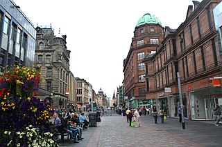
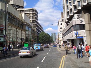
Argyle Street is a major thoroughfare in the city centre of Glasgow, Scotland.
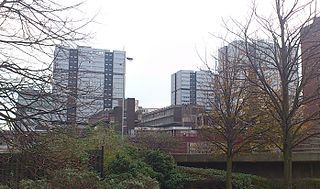
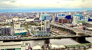
The Anderston Centre is a mixed-use commercial and residential complex, and former bus station located in the Anderston area of Glasgow, Scotland. Completed in 1972 and designed by Richard Seifert, it is one of the earliest examples of the "megastructure" style of urban renewal scheme fashionable in the 1950s and 1960s - the other notable example in Scotland being the infamous Cumbernauld Town Centre development. The complex is a notable landmark on the western edge of Glasgow city centre, and is highly visible from the adjacent Kingston Bridge.
St George's Cross is a road junction in the Woodside area of Glasgow, Scotland. Previously a major intersection for traffic approaching the central areas of the city from its north-western parts, two of the roads forming the junction, Great Western Road and Maryhill Road, were bypassed at the original site in a 1960s realignment, whereas New City Road has had access for vehicular traffic blocked off from the junction itself and is now accessed via Gladstone Street. The cross is now the meeting point of St George's Road, St George's Place, Clarendon Place and New City Road.

Elmbank Gardens is a multi-use commercial complex in the Charing Cross area of Glasgow, Scotland. Best known for its signature 13-storey tower which overlooks the M8 motorway and stands directly opposite the Mitchell Library, it was designed by Richard Seifert and constructed between 1970 and 1972. It is one of the tallest and most prominent high rise buildings on the western side of Glasgow city centre, beyond Blythswood Hill. The surface buildings of the subterranean railway station which serves Charing Cross are also an integral part of the complex.
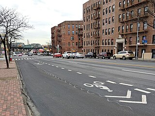
Westchester Avenue is a major east–west street in the South and East portions of the Bronx, New York City. It runs from Third Avenue and East 150th Street in the Hub to Pelham Bay Park in the Pelham Bay section. It crosses many neighborhoods of the Bronx, which include Melrose, Longwood, Soundview, Parkchester, and Pelham Bay. Westchester Avenue parallels the Bruckner Expressway until their junction at Pelham Bay Park.

Sandyford is an area of Glasgow, Scotland. It is north of the River Clyde and forms part of the western periphery of the city centre. Formerly the name of a ward under Glasgow Town Council in the first part of the 20th century, it is within a continuous area of fairly dense urban development bordering several other neighbourhoods whose mutual boundaries have blurred over time, and is possibly less well known than all of the places which adjoin it, particularly Anderston and Finnieston.