
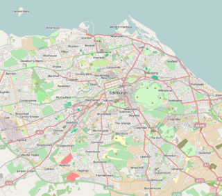
Midlothian is a historic county, registration county, lieutenancy area and one of 32 council areas of Scotland used for local government. Midlothian lies in the east-central Lowlands, bordering the City of Edinburgh, East Lothian and the Scottish Borders.

Swanston is a village and residential area on the southern edge of Edinburgh, Scotland, noted for its picturesque thatched cottages set around an informal village green. Because of its relatively isolated position at the foot of the Pentland Hills, it has remained largely unaffected by commercial or suburban development.
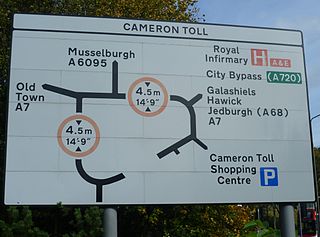
Cameron Toll is a suburb located to the south of Edinburgh, Scotland. Originally it was the site of a toll house built in the early 19th century, which was located on a stretch of road between Edinburgh and Dalkeith. The meaning of the name Cameron is suggested to be 'crooked hill', derived from the Scots Gaelic 'cam', crooked, and Old Gaelic 'brun' meaning hill, believed to refer to Arthur’s Seat clearly visible nearby; the original name may have been Pictish.

The Calders is a residential neighbourhood in Edinburgh, Scotland – not to be confused with the Calders of West Lothian aka West Calder, Mid Calder and East Calder, three separate villages. It is sometimes considered to be part of Wester Hailes or Sighthill, larger developments to its south and east respectively. From 2007 to 2017, it fell within the Sighthill/Gorgie multi-member ward of the City of Edinburgh Council administration along with Sighthill, but following a boundary change has been in the Pentland Hills ward since then, along with Wester Hailes.
Clan Sinclair is a Highland Scottish clan who held lands in Caithness, the Orkney Islands, and the Lothians. The chiefs of the clan were the Barons of Roslin and later the Earls of Orkney and Earls of Caithness. The Sinclairs are believed to have come from Normandy to England during the Norman conquest of England, before arriving in Scotland in the 11th century. The Sinclairs supported the Scottish Crown during the Scottish–Norwegian War and the Wars of Scottish Independence. The chiefs were originally Barons of Roslin, Midlothian and William Sinclair, 1st Earl of Caithness and Baron of Roslin founded the famous Rosslyn Chapel in the 15th century. He split the family lands, disinheriting his eldest son from his first marriage, William, who inherited the title of Lord Sinclair, instead giving the lands of Caithness to the second son from his second marriage, William Sinclair, 2nd Earl of Caithness, in 1476, and the lands at Roslin to his eldest son from his second marriage, Sir Oliver Sinclair. In the 16th century the Sinclairs fought against England during the Anglo-Scottish Wars and also feuded with their neighbors the Clan Sutherland. During the Jacobite rising of 1715 the Sinclairs supported the Jacobite cause, but during the Jacobite rising of 1745, while the clan largely had Jacobite sympathies, their chief, the Earl of Caithness, supported the British-Hanoverian Government. The current chief is Malcolm Sinclair, 20th Earl of Caithness.

Lasswade is a village and civil parish in Midlothian, Scotland, on the River North Esk, nine miles south of Edinburgh city centre, contiguous with Bonnyrigg and between Dalkeith to the east and Loanhead to the west. Melville Castle lies to the north east. The Gaelic form is Leas Bhaid, meaning the "clump at the fort."

The Braid Hills form an area towards the south-western edge of Edinburgh, Scotland.
Moredun is a district in the south-east of Edinburgh, the capital of Scotland. It is east of Liberton, while Craigour is situated just to its north.

Baron of Roslin or Rosslyn was a Scottish feudal barony held by the St Clair or Sinclair family.

Dumbiedykes is a residential area in the centre of Edinburgh, Scotland. It mainly comprises public housing developments.

Saltoun Hall is an historic house standing in extensive lands off the B6355, Pencaitland to East Saltoun road, about 1.5 miles from each village, in East Lothian, Scotland. The house is reached by way of an impressive gateway and is situated at grid reference NT461685.

Craig House is a historic house and estate located on Easter Craiglockhart Hill, between the Craiglockhart and Morningside areas of Edinburgh, Scotland. Old Craig House dates from the 16th century, and succeeded an earlier building. In the late 19th century it was purchased by the Royal Edinburgh Hospital, and the site was developed as Craig House Hospital, a psychiatric hospital, including substantial new buildings. Following refurbishment, the site was opened in 1996 as the Craighouse Campus of Edinburgh Napier University.

Thomas Bonnar ( d.1847) was a Scottish interior designer and architect of note, working in the Edinburgh area. He is particularly remembered for his outstanding ceilings.

The Inch is a district of Edinburgh, Scotland, located to the south of Inch Park in the south of the city. It is located 2 miles south south-east of central Edinburgh. It incorporates the Inch housing development, Inch Park and the category A listed Inch House, a former country house now used as a community centre. The associated Inch Doocot or dovecot, also a category A listed building, is situated close by, west of Gilmerton Road.
The Princess Margaret Rose Orthopaedic Hospital was a hospital in Fairmilehead, Edinburgh, opened in 1932 and closed in 2000. After closure, with services transferred to the new Royal Infirmary of Edinburgh, it was demolished and the site sold for housing.
The Mortonhall Crematorium is a multi-denominational crematorium in Edinburgh, Scotland. It is an example of Basil Spence's post-war expressionist style. Opened in 1967, the crematorium is set in mature woodland and is a Category A listed building. A walled memorial garden opened there in December 2015.
Sir Henry St Clair was a 13th-14th century Scottish noble, who was the 7th Baron of Roslin and Lord of Catcune.

Inch House, a former country house situated within Inch Park in Edinburgh, Scotland is a category A listed building. The oldest part, a Scottish vernacular L-plan tower house, dates from the early 17th century. From 1660 it was owned by the Gilmour family, who arranged for additions and extensions to the house in the 18th and 19th centuries. It was sold to the then Edinburgh Corporation in 1945. Since then it has been used as a primary school and more recently as a community centre.
Morton is a locality and former barony, in Edinburgh, Scotland.


